
| FERGUSON ARPT PENSACOLA FL |
| |
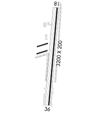
| Lat: N 3023.9 Long: W 08720.9 Elev: 32 Var: -01 Longest Runway: 3225 | ||
| CTAF: 122.8 | ||
| ||||||
|
| Rwy | Rwy | |||||||
| 3225x140 | 2945' | 3225x140 | 3225' | |||||
| Runway ID | Single Wheel | Double Wheel | Double Tandem Wheel | Dual Double Wheel |
| 18/36 | N/A | N/A | N/A | N/A |
| These numbers are Advisory and are not limits. The Airport Manager should have more accurate Weight Limits | ||||
| FltPlan does not have IFR approach charts available for K82J. |
 Airport Diagram might not be current. | |
| Facility Name: | FERGUSON |
| City Name: | PENSACOLA |
| County: | ESCAMBIA |
| State abbrev: | FL |
| State Name: | FLORIDA |
| Ownership: | PRIVATELY OWNED |
| Use: | OPEN TO THE PUBLIC |
| Owner's Name: | BROWN HELICOPTER INC.; THOMAS BROWN |
| Address: | 10100 AILERON AVENUE |
| PENSACOLA, FL 32506 | |
| Owner's Phone: | 850-455-0971 |
| Manager's Name: | KENNY BROWN |
| Address: | 9750 AILERON AVE |
| PENSACOLA, FL 32506 | |
| Phone: | (850) 453-4181 |
| FAA Region: | SOUTHERN |
| FAA Field Office: | ORL |
| Date | Sunrise | Sunset |
|---|---|---|
| 09/24/21 Friday | 6:39 | 18:44 |
| 09/25/21 Saturday | 6:39 | 18:42 |
| 09/26/21 Sunday | 6:40 | 18:41 |
| 09/27/21 Monday | 6:40 | 18:40 |
| 09/28/21 Tuesday | 6:41 | 18:39 |
| 09/29/21 Wednesday | 6:42 | 18:37 |
| 09/30/21 Thursday | 6:42 | 18:36 |
| 10/01/21 Friday | 6:43 | 18:35 |
| 10/02/21 Saturday | 6:43 | 18:34 |
| 10/03/21 Sunday | 6:44 | 18:33 |
| 10/04/21 Monday | 6:45 | 18:31 |
| 10/05/21 Tuesday | 6:45 | 18:30 |
| 10/06/21 Wednesday | 6:46 | 18:29 |
| 10/07/21 Thursday | 6:46 | 18:28 |
| Airport Attendance Schedule | MON-SAT 0900-1700, SUN 1000-1500; AFT HRS CALL 850 453 4181 |
| Airport Status | OPERATIONAL (This Status can change at any time - please check NOTAMS) |
| Airport Lighting Schedule | ACTVT LIRL RWY 18/36 - CTAF. |
| Airport Storage Available | Tie Downs, Hanger |
| Extra Services Available | Air Ambulance, Flight Instruction, Aircraft Rental, Annual Surveying |
| Wind Indicator | YES - (unlit) |
| Control Tower | NO |
| CTAF Frequency | 122.800 |
| Unicom Frequency | 122.800 |
| Rotating Beacon Color | |
| Segmented Circle | NO |
| Landing Fee | NO |
| Airport Inspected | STATE - performed by STATE AERONAUTICAL PERSONNEL |
| Inspection Date | 03/06/2018 |
| Type of Fuel Available | Grade 100LL, JET A; -1024 HR FUEL AVBL. |
| Airframe Repair Service | MAJOR |
| Power Plant Repair Service | MAJOR |
| Latitude | N3023.9 |
| Longitude | W08720.9 (ESTIMATED) |
| Arpt Elevation | 32ft (SURVEYED) |
| Magnetic Variation | 01E |
| 7 miles SW | of PENSACOLA |
| Traffic Pattern Altitude | |
| Sectional Chart | NEW ORLEANS |
| Operations (Reported) | Yearly | Avg. Daily |
|---|---|---|
| General Aviation Transient | 17500 | 48 |
| General Aviation Local | 50000 | 137 |
| Air Taxi | 0 | 0 |
| Commerical | 0 | 0 |
| Commuter | 0 | 0 |
| Military | 0 | 0 |
| Aircraft based on Field | |
|---|---|
| General Aviation Singles | 30 |
| General Aviation Multi | 1 |
| Jet Aircraft | 0 |
| General Aviation Helicopters | 2 |
| Military Aircraft | 0 |
| Gliders | 0 |
| Ultralights | 0 |
| FSS on field | NO |
| FSS tie-in | GAINESVILLE |
| FSS Phone | 1-800-WX-BRIEF |
| Who issues Notams | GNV |
| Notam D service at airport | YES |
| ARTCC Name | JACKSONVILLE |
| Airport Certification | |
| Aircraft Rescue & Firefighting Index | None |
| Airport of Entry | No |
| Custom Landing Rights | No |
| Joint Civil/Military | No |
| Military Landing rights | No |
| APCH AND DEP NORTH OF THE ARPT |
| ARPT LIES WITHIN 3 NM OF NAS PENSACOLA SHERMAN FIELD (NPA). |
| FREQUENT FLIGHT DEMONSTRATIONS AND PRACTICE AIRSHOWS AT NPA. |
| FOR CD CTC PENSACOLA APCH AT 850-266-6884 OR 850-266-6885. |
| RWY 18/3 6 80 FT WRN PTN OF RWY IS TURF, 40 FT CNTR PTN OF RWY IS ASPH, 20 FT ERN PTN IS TURF. |
| RWY 18/3 6 RWY LGTS 200 FT SPACING USING LEDS. RWY 18/36 MKD WITH PAVERS & LGTS. |
| Runway: 18 | Runway: 36 | ||
| Mag heading: | N/A | Mag heading: | N/A |
| Rwy Slope: | .12% Up | Rwy Slope: | -.12% Down |
| Approach: | Approach: | ||
| Pattern: | Left Traffic | Pattern: | Left Traffic |
| Markings: | NONSTANDARD | Markings: | NONSTANDARD |
| Marking Condition: | GOOD | Marking Condition: | GOOD |
| Arresting Dev: | Arresting Dev: | ||
| Lat & Long: | N3024.2 W08720.9 | Lat. & Long.: | N3023.6 W08721.0 |
| Elev: | 28.0 ft. MSL | Elev: | 32.0 ft. MSL |
| TCH: | TCH: | ||
| Visual Glide Path: | Visual Glide Path: | ||
| Displaced Threshold: | 280 feet | Displaced Threshold: | No |
| Touchdown Zone: | NO | Touchdown Zone: | NO |
| Touchdown Elev.: | Touchdown Elev.: | ||
| Visual Glide Slope: | Visual Glide Slope: | ||
| RVR Equipment: | RVR Equipment: | ||
| RVV Equipment: | NO | RVV Equipment: | NO |
| Approach Lights: | Approach Lights: | ||
| REIL: | NO | REIL: | NO |
| Centerline Lights: | NO | Centerline Lights: | NO |
| Touchdown lights: | NO | Touchdown lights: | NO |
| Runway Category: | Runway with a Visual Approach | Runway Category: | Runway with a Visual Approach |
| Declared Distances: | Declared Distances: | ||
| Obstructions: | TREE | Obstructions: | TREE |
| Marked: | NOT Marked/Lighted | Marked: | NOT Marked/Lighted |
| Clearance slope: | 10:1; APCH RATIO 20:1 TO DSPLCD THLD. | Clearance slope: | 20:1 |
| Obstruction height: | 36 feet AGL | Obstruction height: | 16 feet AGL |
| Dist. from runway: | 357 feet | Dist. from runway: | 314 feet |
| Centerline offset: | 75 left of centerline | Centerline offset: | 10 feet left of centerline |
| Comments: | Comments: |
Thanks for using FltPlan.com
all rights reserved © 1999-2021 by Flight Plan LLC
