
| MARION COUNTY BUENA VISTA GA |
| |
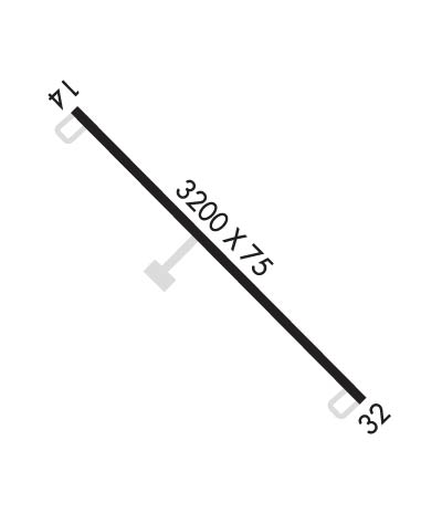
| Lat: N 3217.0 Long: W 08430.2 Elev: 682 Var: +02 Longest Runway: 3200 | ||
| CTAF: 122.9 | ||
| ||||||||||||||||||||||||||||||||
| ||||||||||||||||||||||||||||||||
| Rwy | Rwy | |||||||
| 3200x75 | 3200' | 3200x75 | 3200' | |||||
| Runway ID | Single Wheel | Double Wheel | Double Tandem Wheel | Dual Double Wheel |
| 14/32 | 14,000 | N/A | N/A | N/A |
| These numbers are Advisory and are not limits. The Airport Manager should have more accurate Weight Limits | ||||
| FltPlan does not have IFR approach charts available for K82A. |
 Airport Diagram might not be current. | |
| Facility Name: | MARION COUNTY |
| City Name: | BUENA VISTA |
| County: | MARION |
| State abbrev: | GA |
| State Name: | GEORGIA |
| Ownership: | PUBLICLY OWNED |
| Use: | OPEN TO THE PUBLIC |
| Owner's Name: | MARION COUNTY |
| Address: | PO BOX 481 |
| BUENA VISTA, GA 31803 | |
| Owner's Phone: | 229-649-2603 |
| Manager's Name: | GEORGE NEAL |
| Address: | 100 EAST BURKHALTER AVE, PO BOX 481 |
| BUENA VISTA, GA 31803 | |
| Phone: | 229-649-2603 |
| FAA Region: | SOUTHERN |
| FAA Field Office: | ATL |
| Date | Sunrise | Sunset |
|---|---|---|
| 09/24/21 Friday | 7:27 | 19:32 |
| 09/25/21 Saturday | 7:28 | 19:31 |
| 09/26/21 Sunday | 7:29 | 19:30 |
| 09/27/21 Monday | 7:29 | 19:28 |
| 09/28/21 Tuesday | 7:30 | 19:27 |
| 09/29/21 Wednesday | 7:31 | 19:26 |
| 09/30/21 Thursday | 7:31 | 19:24 |
| 10/01/21 Friday | 7:32 | 19:23 |
| 10/02/21 Saturday | 7:32 | 19:22 |
| 10/03/21 Sunday | 7:33 | 19:20 |
| 10/04/21 Monday | 7:34 | 19:19 |
| 10/05/21 Tuesday | 7:34 | 19:18 |
| 10/06/21 Wednesday | 7:35 | 19:17 |
| 10/07/21 Thursday | 7:36 | 19:15 |
| Airport Attendance Schedule | UNATTENDED |
| Airport Status | OPERATIONAL (This Status can change at any time - please check NOTAMS) |
| Airport Lighting Schedule | ACTVT MIRL RWY 14/32 -CTAF. |
| Airport Storage Available | Tie Downs |
| Extra Services Available | NONE |
| Wind Indicator | YES - (unlit) |
| Control Tower | NO |
| CTAF Frequency | 122.900 |
| Unicom Frequency | |
| Rotating Beacon Color | |
| Segmented Circle | YES |
| Landing Fee | NO |
| Airport Inspected | STATE - performed by STATE AERONAUTICAL PERSONNEL |
| Inspection Date | 06/02/2021 |
| Type of Fuel Available | None |
| Airframe Repair Service | NONE |
| Power Plant Repair Service | NONE |
| Latitude | N3217.0 |
| Longitude | W08430.2 (ESTIMATED) |
| Arpt Elevation | 682ft (SURVEYED) |
| Magnetic Variation | 02W |
| 3 miles SE | of BUENA VISTA |
| Traffic Pattern Altitude | |
| Sectional Chart | ATLANTA |
| Operations (Reported) | Yearly | Avg. Daily |
|---|---|---|
| General Aviation Transient | 600 | 2 |
| General Aviation Local | 600 | 2 |
| Air Taxi | 0 | 0 |
| Commerical | 0 | 0 |
| Commuter | 0 | 0 |
| Military | 0 | 0 |
| Aircraft based on Field | |
|---|---|
| General Aviation Singles | 0 |
| General Aviation Multi | 0 |
| Jet Aircraft | 0 |
| General Aviation Helicopters | 0 |
| Military Aircraft | 0 |
| Gliders | 0 |
| Ultralights | 0 |
| FSS on field | NO |
| FSS tie-in | MACON |
| FSS Phone | 1-800-WX-BRIEF |
| Who issues Notams | MCN |
| Notam D service at airport | YES |
| ARTCC Name | ATLANTA |
| Airport Certification | |
| Aircraft Rescue & Firefighting Index | None |
| Airport of Entry | No |
| Custom Landing Rights | No |
| Joint Civil/Military | No |
| Military Landing rights | YES |
| GRANT AGREEMENTS UNDER FAAP/ADAP/AIP |
| ASSURANCES PURSUANT TO TITLE VI, CIVIL RIGHTS ACT OF 1964 |
| PAEW ON & INVOF RWY. |
| FOR CD CTC ATLANTA APCH AT 678-364-6132, WHEN APCH CLSD CTC ATLANTA ARTCC AT 770-210-7692. |
| Runway: 14 | Runway: 32 | ||
| Mag heading: | N/A | Mag heading: | N/A |
| Approach: | Approach: | ||
| Pattern: | Left Traffic | Pattern: | Left Traffic |
| Markings: | BASIC | Markings: | BASIC |
| Marking Condition: | GOOD | Marking Condition: | GOOD |
| Arresting Dev: | Arresting Dev: | ||
| Lat & Long: | N3217.2 W08430.4 | Lat. & Long.: | N3216.8 W08430.0 |
| Elev: | N/A | Elev: | N/A |
| TCH: | TCH: | ||
| Visual Glide Path: | Visual Glide Path: | ||
| Displaced Threshold: | No | Displaced Threshold: | No |
| Touchdown Zone: | NO | Touchdown Zone: | NO |
| Touchdown Elev.: | Touchdown Elev.: | ||
| Visual Glide Slope: | Visual Glide Slope: | ||
| RVR Equipment: | RVR Equipment: | ||
| RVV Equipment: | NO | RVV Equipment: | NO |
| Approach Lights: | Approach Lights: | ||
| REIL: | NO | REIL: | NO |
| Centerline Lights: | NO | Centerline Lights: | NO |
| Touchdown lights: | NO | Touchdown lights: | NO |
| Runway Category: | Runway with a Visual Approach | Runway Category: | Runway with a Visual Approach |
| Declared Distances: | Declared Distances: | ||
| Obstructions: | TREES | Obstructions: | TREES |
| Marked: | NOT Marked/Lighted | Marked: | NOT Marked/Lighted |
| Clearance slope: | 25:1 | Clearance slope: | 34:1 |
| Obstruction height: | 34 feet AGL | Obstruction height: | 38 feet AGL |
| Dist. from runway: | 1050 feet | Dist. from runway: | 1492 feet |
| Centerline offset: | 200 left of centerline | Centerline offset: | 210 feet right of centerline |
| Comments: | Comments: |
Thanks for using FltPlan.com
all rights reserved © 1999-2021 by Flight Plan LLC
