
| OXFORD COUNTY RGNL OXFORD ME |
| |
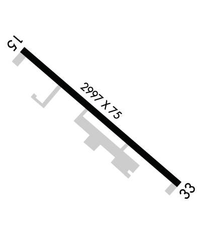
| Lat: N 4409.4 Long: W 07028.9 Elev: 345 Var: +17 Longest Runway: 2997 | ||
| Clr Del: 207-874-7320 CTAF: 122.8 | ||
| ||||||||||||||||||||||||||||||||||||||||||||
| ||||||||||||||||||||||||||||||||||||||||||||
| Rwy | Rwy | |||||||
| 2997x75 | 2997' | 2997x75 | 2997' | |||||
| Runway ID | Single Wheel | Double Wheel | Double Tandem Wheel | Dual Double Wheel |
| 15/33 | 25,000 | N/A | N/A | N/A |
| These numbers are Advisory and are not limits. The Airport Manager should have more accurate Weight Limits | ||||
 Airport Diagram might not be current. | |
| Facility Name: | OXFORD COUNTY RGNL |
| City Name: | OXFORD |
| County: | OXFORD |
| State abbrev: | ME |
| State Name: | MAINE |
| Ownership: | PUBLICLY OWNED |
| Use: | OPEN TO THE PUBLIC |
| Owner's Name: | OXFORD COUNTY |
| Address: | PO BOX 179, 26 WESTERN AVE |
| SOUTH PARIS, ME 04281 | |
| Owner's Phone: | 207-461-5040; EMERG FONE: 207-743-6336 OXFORD COUNTY EMA. |
| Manager's Name: | TONY CARTER - CO ADMIR |
| Address: | PO BOX 179, 26 WESTERN AVE |
| SOUTH PARIS, ME 04281 | |
| Phone: | 207-461-5040 |
| FAA Region: | NEW ENGLAND |
| FAA Field Office: | NONE |
| Date | Sunrise | Sunset |
|---|---|---|
| 06/08/26 Monday | 4:59 | 20:23 |
| 06/09/26 Tuesday | 4:59 | 20:24 |
| 06/10/26 Wednesday | 4:58 | 20:25 |
| 06/11/26 Thursday | 4:58 | 20:25 |
| 06/12/26 Friday | 4:58 | 20:26 |
| 06/13/26 Saturday | 4:58 | 20:26 |
| 06/14/26 Sunday | 4:58 | 20:27 |
| 06/15/26 Monday | 4:58 | 20:27 |
| 06/16/26 Tuesday | 4:58 | 20:27 |
| 06/17/26 Wednesday | 4:58 | 20:28 |
| 06/18/26 Thursday | 4:58 | 20:28 |
| 06/19/26 Friday | 4:58 | 20:28 |
| 06/20/26 Saturday | 4:58 | 20:29 |
| 06/21/26 Sunday | 4:58 | 20:29 |
| Airport Attendance Schedule | MON-SAT 0700-1700, SUN UNATNDD |
| Airport Status | OPERATIONAL (This Status can change at any time - please check NOTAMS) |
| Airport Lighting Schedule | ACTVT MIRL RWY 15/33 - CTAF. |
| Airport Storage Available | Tie Downs, Hanger |
| Extra Services Available | Flight Instruction, Aircraft Rental |
| Wind Indicator | YES - (lighted) |
| Control Tower | NO |
| CTAF Frequency | 122.800 |
| Unicom Frequency | 122.800 |
| Rotating Beacon Color | WG |
| Segmented Circle | YES |
| Landing Fee | NO |
| Airport Inspected | STATE - performed by PRIVATE CONTRACT PERSONNEL |
| Inspection Date | 08/08/2025 |
| Type of Fuel Available | Grade 100LL; -10SELF-SVC 100LL AVBL 24 HRS. |
| Airframe Repair Service | MAJOR; FOR MAINT CALL 207-539-6065. |
| Power Plant Repair Service | MAJOR; FOR MAINT CALL 207-539-6065. |
| Latitude | N4409.4 |
| Longitude | W07028.9 (ESTIMATED) |
| Arpt Elevation | 345ft (SURVEYED) |
| Magnetic Variation | 17W |
| 2 miles E | of OXFORD |
| Traffic Pattern Altitude | |
| Sectional Chart | MONTREAL; ADDNL SECTIONAL CHART NEW YORK. |
| Operations (Reported) | Yearly | Avg. Daily |
|---|---|---|
| General Aviation Transient | 0 | 0 |
| General Aviation Local | 0 | 0 |
| Air Taxi | 0 | 0 |
| Commerical | 0 | 0 |
| Commuter | 0 | 0 |
| Military | 0 | 0 |
| Aircraft based on Field | |
|---|---|
| General Aviation Singles | 0 |
| General Aviation Multi | 0 |
| Jet Aircraft | 0 |
| General Aviation Helicopters | 0 |
| Military Aircraft | 0 |
| Gliders | 0 |
| Ultralights | 0 |
| FSS on field | NO |
| FSS tie-in | BANGOR |
| FSS Phone | 1-800-WX-BRIEF |
| Who issues Notams | BGR |
| Notam D service at airport | YES |
| ARTCC Name | BOSTON |
| Airport Certification | |
| Aircraft Rescue & Firefighting Index | None |
| Airport of Entry | No |
| Custom Landing Rights | No |
| Joint Civil/Military | No |
| Military Landing rights | YES |
| NATIONAL PLAN OF INTEGRATED AIRPORT SYSTEMS (NPIAS) |
| GRANT AGREEMENTS UNDER FAAP/ADAP/AIP |
| ASSURANCES PURSUANT TO TITLE VI, CIVIL RIGHTS ACT OF 1964 |
| THIS AIRPORT HAS BEEN SURVEYED BY THE NATIONAL GEODETIC SURVEY. |
| RWY 15/33 HAS 2 IN DROP-OFFS LCTD ON ALL SIDES & THLDS. |
| WILDLIFE ON & INVOF ARPT. |
| FOR CD CTC PORTLAND APCH AT 207-874-7320, WHEN APCH CLSD CTC BOSTON ARTCC AT 603-879-6859. |
Airport Communications & Frequencies:
| |||||||||||||||||
| Runway: 15 | Runway: 33 | ||
| Mag heading: | 149° | Mag heading: | 329° |
| Rwy Slope: | -.26% Down | Rwy Slope: | .26% Up |
| Approach: | Approach: | ||
| Pattern: | Left Traffic | Pattern: | Left Traffic |
| Markings: | NONPRECISION INSTRUMENT | Markings: | NONPRECISION INSTRUMENT |
| Marking Condition: | FAIR | Marking Condition: | FAIR |
| Arresting Dev: | Arresting Dev: | ||
| Lat & Long: | N4409.6 W07029.1 | Lat. & Long.: | N4409.3 W07028.6 |
| Elev: | 345.0 ft. MSL | Elev: | 337.3 ft. MSL |
| TCH: | TCH: | ||
| Visual Glide Path: | Visual Glide Path: | ||
| Displaced Threshold: | No | Displaced Threshold: | No |
| Touchdown Zone: | YES | Touchdown Zone: | YES |
| Touchdown Elev.: | 345.0 feet | Touchdown Elev.: | 345.0 feet |
| Visual Glide Slope: | Visual Glide Slope: | ||
| RVR Equipment: | RVR Equipment: | ||
| RVV Equipment: | NO | RVV Equipment: | NO |
| Approach Lights: | Approach Lights: | ||
| REIL: | NO | REIL: | NO |
| Centerline Lights: | NO | Centerline Lights: | NO |
| Touchdown lights: | NO | Touchdown lights: | NO |
| Runway Category: | Runway with a Non-precision Approach | Runway Category: | Runway with a Non-precision Approach |
| Declared Distances: | Declared Distances: | ||
| Obstructions: | Unknown | Obstructions: | |
| Marked: | NOT Marked/Lighted | Marked: | |
| Clearance slope: | 8:1 | Clearance slope: | 20:1 |
| Obstruction height: | 32 feet AGL | Obstruction height: | |
| Dist. from runway: | 467 feet | Dist. from runway: | |
| Centerline offset: | 203 right of centerline | Centerline offset: | |
| Comments: | 6-10 FT TREES, 75-125 FT FM THR, 170-185 FT RITE OF CNTRLN. | Comments: |
Thanks for using FltPlan.com
all rights reserved © 1999-2026 by Flight Plan LLC
