
| HENRY COUNTY NAPOLEON OH |
| |
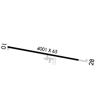
| Lat: N 4122.5 Long: W 08404.1 Elev: 683 Var: +05 Longest Runway: 4001 | ||
| CTAF: 123.0 | ||
| ||||||||||||||||||||||||||||||||||||||||||||
| ||||||||||||||||||||||||||||||||||||||||||||
| Rwy | Rwy | |||||||
| 4001x60 | 4001' | 4001x60 | 4001' | |||||
| Runway ID | Single Wheel | Double Wheel | Double Tandem Wheel | Dual Double Wheel |
| 10/28 | N/A | N/A | N/A | N/A |
| These numbers are Advisory and are not limits. The Airport Manager should have more accurate Weight Limits | ||||
 Airport Diagram might not be current. | |
| Facility Name: | HENRY COUNTY |
| City Name: | NAPOLEON |
| County: | HENRY |
| State abbrev: | OH |
| State Name: | OHIO |
| Ownership: | PUBLICLY OWNED |
| Use: | OPEN TO THE PUBLIC |
| Owner's Name: | HENRY CO ARPT AUTH |
| Address: | 10646 COUNTY ROAD O |
| NAPOLEON, OH 43545-6217 | |
| Owner's Phone: | 419-599-6494 |
| Manager's Name: | JARED AMES, ACTING AMGR |
| Address: | 10646 COUNTY ROAD O |
| NAPOLEON, OH 43545-6217 | |
| Phone: | 419-599-6494; CELL 419-388-9259. |
| FAA Region: | GREAT LAKES |
| FAA Field Office: | DET |
| Date | Sunrise | Sunset |
|---|---|---|
| 06/08/26 Monday | 6:03 | 21:08 |
| 06/09/26 Tuesday | 6:03 | 21:08 |
| 06/10/26 Wednesday | 6:03 | 21:09 |
| 06/11/26 Thursday | 6:02 | 21:10 |
| 06/12/26 Friday | 6:02 | 21:10 |
| 06/13/26 Saturday | 6:02 | 21:10 |
| 06/14/26 Sunday | 6:02 | 21:11 |
| 06/15/26 Monday | 6:02 | 21:11 |
| 06/16/26 Tuesday | 6:02 | 21:12 |
| 06/17/26 Wednesday | 6:02 | 21:12 |
| 06/18/26 Thursday | 6:02 | 21:12 |
| 06/19/26 Friday | 6:03 | 21:13 |
| 06/20/26 Saturday | 6:03 | 21:13 |
| 06/21/26 Sunday | 6:03 | 21:13 |
| Airport Attendance Schedule | MON-FRI 0800-1730, SAT-SUN ON CALL; FOR SVC CALL AMGR CELL. |
| Airport Status | OPERATIONAL (This Status can change at any time - please check NOTAMS) |
| Airport Lighting Schedule | ACTVT REIL RWY 10 & 28; PAPI RWY 10 & 28; MIRL RWY 10/28 - CTAF. |
| Airport Storage Available | Tie Downs, Hanger |
| Extra Services Available | Aircraft Sales |
| Wind Indicator | YES - (lighted) |
| Control Tower | NO |
| CTAF Frequency | 123.000 |
| Unicom Frequency | 123.000 |
| Rotating Beacon Color | WG |
| Segmented Circle | NO |
| Landing Fee | NO |
| Airport Inspected | STATE - performed by STATE AERONAUTICAL PERSONNEL |
| Inspection Date | 10/03/2023 |
| Type of Fuel Available | Grade 100LL, JET A (freeze point -40C) |
| Airframe Repair Service | MAJOR |
| Power Plant Repair Service | MAJOR |
| Latitude | N4122.5 |
| Longitude | W08404.1 (ESTIMATED) |
| Arpt Elevation | 682ft (SURVEYED) |
| Magnetic Variation | 05W |
| 3 miles E | of NAPOLEON |
| Traffic Pattern Altitude | |
| Sectional Chart | DETROIT |
| Operations (Reported) | Yearly | Avg. Daily |
|---|---|---|
| General Aviation Transient | 0 | 0 |
| General Aviation Local | 0 | 0 |
| Air Taxi | 0 | 0 |
| Commerical | 0 | 0 |
| Commuter | 0 | 0 |
| Military | 0 | 0 |
| Aircraft based on Field | |
|---|---|
| General Aviation Singles | 0 |
| General Aviation Multi | 0 |
| Jet Aircraft | 0 |
| General Aviation Helicopters | 0 |
| Military Aircraft | 0 |
| Gliders | 0 |
| Ultralights | 0 |
| FSS on field | NO |
| FSS tie-in | CLEVELAND |
| FSS Phone | 1-800-WX-BRIEF |
| Who issues Notams | CLE |
| Notam D service at airport | YES |
| ARTCC Name | CLEVELAND |
| Airport Certification | |
| Aircraft Rescue & Firefighting Index | None |
| Airport of Entry | No |
| Custom Landing Rights | No |
| Joint Civil/Military | No |
| Military Landing rights | No |
| NATIONAL PLAN OF INTEGRATED AIRPORT SYSTEMS (NPIAS) |
| FOR CD CTC TOLEDO APCH AT 419-865-1495. |
Airport Communications & Frequencies:
| ||||||||||||||
| Runway: 10 | Runway: 28 | ||
| Mag heading: | 106° | Mag heading: | 286° |
| Rwy Slope: | .05% Up | Rwy Slope: | -.05% Down |
| Approach: | Approach: | ||
| Pattern: | Left Traffic | Pattern: | Left Traffic |
| Markings: | NONPRECISION INSTRUMENT | Markings: | NONPRECISION INSTRUMENT |
| Marking Condition: | GOOD | Marking Condition: | GOOD |
| Arresting Dev: | Arresting Dev: | ||
| Lat & Long: | N4122.5 W08404.5 | Lat. & Long.: | N4122.4 W08403.6 |
| Elev: | 680.8 ft. MSL | Elev: | 682.8 ft. MSL |
| TCH: | 25 ft. AGL | TCH: | 25 ft. AGL |
| Visual Glide Path: | 3.00 degrees | Visual Glide Path: | 3.00 degrees |
| Displaced Threshold: | No | Displaced Threshold: | No |
| Touchdown Zone: | YES | Touchdown Zone: | YES |
| Touchdown Elev.: | 682.9 feet | Touchdown Elev.: | 682.9 feet |
| Visual Glide Slope: | 2-Light PAPI on LEFT side of Runway | Visual Glide Slope: | 2-Light PAPI on LEFT side of Runway |
| RVR Equipment: | RVR Equipment: | ||
| RVV Equipment: | NO | RVV Equipment: | NO |
| Approach Lights: | Approach Lights: | ||
| REIL: | YES | REIL: | YES |
| Centerline Lights: | NO | Centerline Lights: | NO |
| Touchdown lights: | NO | Touchdown lights: | NO |
| Runway Category: | Runway with a Visual Approach | Runway Category: | Runway with a Non-precision Approach |
| Declared Distances: | Declared Distances: | ||
| Obstructions: | CROPS | Obstructions: | CROPS |
| Marked: | NOT Marked/Lighted | Marked: | NOT Marked/Lighted |
| Clearance slope: | CTLG OBSTN EXCEEDS A 45 DEG SLP. | Clearance slope: | CTLG OBSTN EXCEEDS A 45 DEG SLP. |
| Obstruction height: | 5 feet AGL | Obstruction height: | 6 feet AGL |
| Dist. from runway: | 200 feet | Dist. from runway: | 200 feet |
| Centerline offset: | 95 right of centerline | Centerline offset: | 125 feet left of centerline |
| Comments: | +5 FT CROPS/CULTIVATED FLD, 140-200 FT DIST, 95-125 FT R. | Comments: | +6 FT CROPS/CULTIVATED FLD, 0-200 FT DIST, 125 FT L TO 130 FT R. |
Thanks for using FltPlan.com
all rights reserved © 1999-2026 by Flight Plan LLC
