
| BUTTER VALLEY GOLF PORT BALLY PA |
| |
| Lat: N 4023.8 Long: W 07533.8 Elev: 500 Var: +11 Longest Runway: 2420T | ||
| CTAF: 122.9 | ||
| ||||||||||||||||||||||||||||||||
| ||||||||||||||||||||||||||||||||
| Rwy | Rwy | |||||||
| 2420x85 | 2215' | 2420x85 | 2170' | |||||
| Runway ID | Single Wheel | Double Wheel | Double Tandem Wheel | Dual Double Wheel |
| 16/34 | N/A | N/A | N/A | N/A |
| These numbers are Advisory and are not limits. The Airport Manager should have more accurate Weight Limits | ||||
| FltPlan does not have IFR approach charts available for K7N8. |
| Facility Name: | BUTTER VALLEY GOLF PORT |
| City Name: | BALLY |
| County: | MONTGOMERY |
| State abbrev: | PA |
| State Name: | PENNSYLVANIA |
| Ownership: | PRIVATELY OWNED |
| Use: | OPEN TO THE PUBLIC |
| Owner's Name: | JOHN L GEHMAN |
| Address: | SOUTH 7TH ST |
| BALLY, PA 19503 | |
| Owner's Phone: | 610-845-2491 |
| Manager's Name: | JOHN L. GEHMAN |
| Address: | SOUTH 7TH ST, BOX 207 |
| BALLY, PA 19503 | |
| Phone: | 610-845-2491 |
| FAA Region: | EASTERN |
| FAA Field Office: | HAR |
| Date | Sunrise | Sunset |
|---|---|---|
| 09/24/21 Friday | 6:51 | 18:56 |
| 09/25/21 Saturday | 6:52 | 18:55 |
| 09/26/21 Sunday | 6:53 | 18:53 |
| 09/27/21 Monday | 6:54 | 18:51 |
| 09/28/21 Tuesday | 6:55 | 18:50 |
| 09/29/21 Wednesday | 6:56 | 18:48 |
| 09/30/21 Thursday | 6:57 | 18:46 |
| 10/01/21 Friday | 6:58 | 18:45 |
| 10/02/21 Saturday | 6:59 | 18:43 |
| 10/03/21 Sunday | 7:00 | 18:42 |
| 10/04/21 Monday | 7:01 | 18:40 |
| 10/05/21 Tuesday | 7:02 | 18:38 |
| 10/06/21 Wednesday | 7:03 | 18:37 |
| 10/07/21 Thursday | 7:04 | 18:35 |
| Airport Attendance Schedule | 7 Days A Week DALGT |
| Airport Status | OPERATIONAL (This Status can change at any time - please check NOTAMS) |
| Airport Lighting Schedule | |
| Airport Storage Available | Tie Downs, Hanger |
| Extra Services Available | NONE |
| Wind Indicator | YES - (unlit) |
| Control Tower | NO |
| CTAF Frequency | 122.900 |
| Unicom Frequency | |
| Rotating Beacon Color | |
| Segmented Circle | NO |
| Landing Fee | NO |
| Airport Inspected | STATE - performed by STATE AERONAUTICAL PERSONNEL |
| Inspection Date | 05/24/2021 |
| Type of Fuel Available | None |
| Airframe Repair Service | NONE |
| Power Plant Repair Service | NONE |
| Latitude | N4023.8 |
| Longitude | W07533.8 (ESTIMATED) |
| Arpt Elevation | 500ft (ESTIMATED) |
| Magnetic Variation | 11W |
| 1 miles E | of BALLY |
| Traffic Pattern Altitude | |
| Sectional Chart | NEW YORK |
| Operations (Reported) | Yearly | Avg. Daily |
|---|---|---|
| General Aviation Transient | 200 | 1 |
| General Aviation Local | 400 | 1 |
| Air Taxi | 0 | 0 |
| Commerical | 0 | 0 |
| Commuter | 0 | 0 |
| Military | 0 | 0 |
| Aircraft based on Field | |
|---|---|
| General Aviation Singles | 15 |
| General Aviation Multi | 1 |
| Jet Aircraft | 0 |
| General Aviation Helicopters | 0 |
| Military Aircraft | 0 |
| Gliders | 0 |
| Ultralights | 0 |
| FSS on field | NO |
| FSS tie-in | WILLIAMSPORT |
| FSS Phone | 1-800-WX-BRIEF |
| Who issues Notams | IPT |
| Notam D service at airport | YES |
| ARTCC Name | NEW YORK |
| Airport Certification | |
| Aircraft Rescue & Firefighting Index | None |
| Airport of Entry | No |
| Custom Landing Rights | No |
| Joint Civil/Military | No |
| Military Landing rights | No |
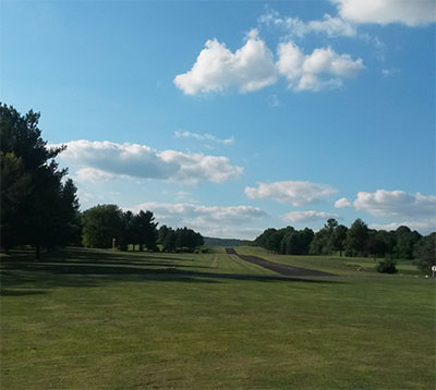
| RWY 16/34 LCTD IN MIDDLE OF GOLF COURSE. |
| TREES & SUBSTANTIAL TRRN ELEV CHGS WITHIN 125 FT OF EACH RWY EDGE. |
| FOR CD CTC ALLENTOWN APCH AT 800-728-6322. |
| RWY 34; 113 FT TREE LINE 1371 FT FM RWY END 217 FT RIGHT; 13:1 SLOPE TO DTHR. |
| RWY 16/3 4 RWY 16/34 1535 FT X 24 FT ASPH INSERT AT S END; REMAINDER TURF. |
| Runway: 16 | Runway: 34 | ||
| Mag heading: | N/A | Mag heading: | N/A |
| Approach: | Approach: | ||
| Pattern: | Left Traffic | Pattern: | Left Traffic |
| Markings: | Markings: | ||
| Marking Condition: | MARKED WITH YELLOW WOOD PANELS; TURF RWY EDGES MARKED WITH TIRES PAINTED YELLOW. | Marking Condition: | |
| Arresting Dev: | Arresting Dev: | ||
| Lat & Long: | Lat. & Long.: | ||
| Elev: | N/A | Elev: | N/A |
| TCH: | TCH: | ||
| Visual Glide Path: | Visual Glide Path: | ||
| Displaced Threshold: | 205 feet; DSPLCD THLD MKD BY 3 YELLOW TIRES. | Displaced Threshold: | 250 feet; DSPLCD THLD MKD BY 3 WHITE LINES. |
| Touchdown Zone: | NO | Touchdown Zone: | NO |
| Touchdown Elev.: | Touchdown Elev.: | ||
| Visual Glide Slope: | Visual Glide Slope: | ||
| RVR Equipment: | RVR Equipment: | ||
| RVV Equipment: | NO | RVV Equipment: | NO |
| Approach Lights: | Approach Lights: | ||
| REIL: | NO | REIL: | NO |
| Centerline Lights: | NO | Centerline Lights: | NO |
| Touchdown lights: | NO | Touchdown lights: | NO |
| Runway Category: | Runway with a Visual Approach | Runway Category: | Runway with a Visual Approach |
| Declared Distances: | Declared Distances: | ||
| Obstructions: | ROAD | Obstructions: | ROAD |
| Marked: | NOT Marked/Lighted | Marked: | NOT Marked/Lighted |
| Clearance slope: | 5:1; APCH RATIO 22:1 TO 205 FT DSPLCD THLD. | Clearance slope: | APCH RATIO 25:1 TO 250 FT DSPLCD THLD. |
| Obstruction height: | 12 feet AGL | Obstruction height: | 10 feet AGL |
| Dist. from runway: | 69 feet | Dist. from runway: | 0 feet |
| Centerline offset: | 50 right of centerline | Centerline offset: | |
| Comments: | Comments: |
Thanks for using FltPlan.com
all rights reserved © 1999-2021 by Flight Plan LLC