
| SPITFIRE AERODROME (CLOSED) PEDRICKTOWN NJ |
| |
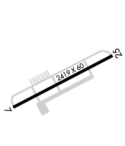
| Lat: N 3944.1 Long: W 07523.9 Elev: 40 Var: +11 Longest Runway: 2419 | ||
| CTAF: 122.7 | ||
| ||
| Rwy | Rwy | |||||||
| 2419x60 | 2221' | 2419x60 | 2419' | |||||
| Runway ID | Single Wheel | Double Wheel | Double Tandem Wheel | Dual Double Wheel |
| 07/25 | N/A | N/A | N/A | N/A |
| These numbers are Advisory and are not limits. The Airport Manager should have more accurate Weight Limits | ||||
| FltPlan does not have IFR approach charts available for K7N7. |
 Airport Diagram might not be current. | |
| Facility Name: | OLDMANS TOWNSHIP |
| City Name: | PEDRICKTOWN |
| County: | SALEM |
| State abbrev: | NJ |
| State Name: | NEW JERSEY |
| Ownership: | PRIVATELY OWNED |
| Use: | OPEN TO THE PUBLIC |
| Owner's Name: | OLDMANS TOWNSHIP AIRPORT AUTHORITY |
| Address: | 37 AIRPORT LANE |
| PEDRICKTOWN, NJ 08067 | |
| Owner's Phone: | 215-219-5600 |
| Manager's Name: | STEVEN R MARTORANO |
| Address: | 37 AIRPORT LANE |
| PEDRICKTOWN, NJ 08067 | |
| Phone: | 215-219-5600 |
| FAA Region: | EASTERN |
| FAA Field Office: | HAR |

| Date | Sunrise | Sunset |
|---|---|---|
| 07/02/24 Tuesday | 5:38 | 20:33 |
| 07/03/24 Wednesday | 5:39 | 20:33 |
| 07/04/24 Thursday | 5:39 | 20:33 |
| 07/05/24 Friday | 5:40 | 20:33 |
| 07/06/24 Saturday | 5:40 | 20:32 |
| 07/07/24 Sunday | 5:41 | 20:32 |
| 07/08/24 Monday | 5:42 | 20:32 |
| 07/09/24 Tuesday | 5:42 | 20:31 |
| 07/10/24 Wednesday | 5:43 | 20:31 |
| 07/11/24 Thursday | 5:44 | 20:30 |
| 07/12/24 Friday | 5:44 | 20:30 |
| 07/13/24 Saturday | 5:45 | 20:29 |
| 07/14/24 Sunday | 5:46 | 20:29 |
| 07/15/24 Monday | 5:47 | 20:28 |
| Airport Attendance Schedule | IREG Irregular Attendance IREG |
| Airport Status | OPERATIONAL (This Status can change at any time - please check NOTAMS) |
| Airport Lighting Schedule | DUSK - DAWN; ACTVT REIL RWY 07 & 25; PAPI RWY 07 & 25; MIRL RWY 07/25 - 122.7. |
| Airport Storage Available | Tie Downs |
| Extra Services Available | Flight Instruction |
| Wind Indicator | YES - (lighted) |
| Control Tower | NO |
| CTAF Frequency | 122.700 |
| Unicom Frequency | 122.700 |
| Rotating Beacon Color | WG |
| Segmented Circle | NO |
| Landing Fee | NO |
| Airport Inspected | STATE - performed by STATE AERONAUTICAL PERSONNEL |
| Inspection Date | 09/14/2022 |
| Type of Fuel Available | None |
| Airframe Repair Service | MAJOR |
| Power Plant Repair Service | MAJOR |
| Latitude | N3944.1 |
| Longitude | W07523.9 (ESTIMATED) |
| Arpt Elevation | 39ft (ESTIMATED) |
| Magnetic Variation | 11W |
| 2 miles S | of PEDRICKTOWN |
| Traffic Pattern Altitude | |
| Sectional Chart | WASHINGTON |
| Operations (Reported) | Yearly | Avg. Daily |
|---|---|---|
| General Aviation Transient | 3015 | 8 |
| General Aviation Local | 8385 | 23 |
| Air Taxi | 0 | 0 |
| Commerical | 0 | 0 |
| Commuter | 0 | 0 |
| Military | 0 | 0 |
| Aircraft based on Field | |
|---|---|
| General Aviation Singles | 19 |
| General Aviation Multi | 1 |
| Jet Aircraft | 0 |
| General Aviation Helicopters | 4 |
| Military Aircraft | 0 |
| Gliders | 0 |
| Ultralights | 0 |
| FSS on field | NO |
| FSS tie-in | MILLVILLE |
| FSS Phone | 1-800-WX-BRIEF |
| Who issues Notams | MIV |
| Notam D service at airport | YES |
| ARTCC Name | WASHINGTON |
| Airport Certification | |
| Aircraft Rescue & Firefighting Index | None |
| Airport of Entry | No |
| Custom Landing Rights | No |
| Joint Civil/Military | No |
| Military Landing rights | No |
| DEER AND BIRDS ON AND INVOF ARPT. |
| ARPT ACCESS RD NEAR APCH END RWY 07. |
| FOR CD CTC PHILADELPHIA APCH AT 800-354-9884. |
| HEL TRNG ACTIVIY ON ARPT. |
Airport Communications & Frequencies:
| |||||||||||||||||
| Runway: 07 | Runway: 25 | ||
| Mag heading: | 74° | Mag heading: | 254° |
| Rwy Slope: | .00% | Rwy Slope: | .00% |
| Approach: | Approach: | ||
| Pattern: | Left Traffic | Pattern: | Left Traffic |
| Markings: | NONPRECISION INSTRUMENT | Markings: | NONPRECISION INSTRUMENT |
| Marking Condition: | FAIR | Marking Condition: | FAIR |
| Arresting Dev: | Arresting Dev: | ||
| Lat & Long: | N3944.0 W07524.1 | Lat. & Long.: | N3944.2 W07523.6 |
| Elev: | 38.2 ft. MSL | Elev: | 38.2 ft. MSL |
| TCH: | 20 ft. AGL | TCH: | 20 ft. AGL |
| Visual Glide Path: | 4.00 degrees | Visual Glide Path: | 4.00 degrees |
| Displaced Threshold: | 198 feet | Displaced Threshold: | No |
| Touchdown Zone: | YES | Touchdown Zone: | YES |
| Touchdown Elev.: | 38.4 feet | Touchdown Elev.: | 38.4 feet |
| Visual Glide Slope: | 2-Light PAPI on LEFT side of Runway | Visual Glide Slope: | 2-Light PAPI on RIGHT side of Runway |
| RVR Equipment: | RVR Equipment: | ||
| RVV Equipment: | NO | RVV Equipment: | NO |
| Approach Lights: | Approach Lights: | ||
| REIL: | YES; REILS INOP INDEFLY. | REIL: | YES; REILS INOP INDEFLY. |
| Centerline Lights: | NO | Centerline Lights: | NO |
| Touchdown lights: | NO | Touchdown lights: | NO |
| Runway Category: | Runway with a Non-precision Approach | Runway Category: | Runway with a Non-precision Approach |
| Declared Distances: | Declared Distances: | ||
| Obstructions: | TREE | Obstructions: | TREE |
| Marked: | NOT Marked/Lighted | Marked: | NOT Marked/Lighted |
| Clearance slope: | 1:1; RWY 07 APCH RATIO 1:1 TO DTHR. | Clearance slope: | 1:1 |
| Obstruction height: | 35 feet AGL | Obstruction height: | 62 feet AGL |
| Dist. from runway: | 239 feet | Dist. from runway: | 275 feet |
| Centerline offset: | 150 right of centerline | Centerline offset: | 223 feet right of centerline |
| Comments: | RWY 07 10 FT ROAD 15 FT FM RWY END ON CNTRLN. | Comments: |
Thanks for using FltPlan.com
all rights reserved © 1999-2024 by Flight Plan LLC