
| MOUNTAIN VIEW WILCOX MEMORIAL MOUNTAIN VIEW AR |
| |
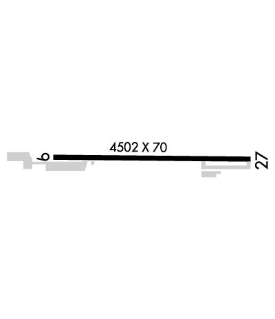
| Lat: N 3551.9 Long: W 09205.4 Elev: 805 Var: -01 Longest Runway: 4502 | ||
| CTAF: 122.7 | ||
| ||||||||||||||||||||||||||||||||||||||||||||
| ||||||||||||||||||||||||||||||||||||||||||||
| Rwy | Rwy | |||||||
| 4502x70 | 4502' | 4502x70 | 4502' | |||||
| Runway ID | Single Wheel | Double Wheel | Double Tandem Wheel | Dual Double Wheel |
| 09/27 | N/A | N/A | N/A | N/A |
| These numbers are Advisory and are not limits. The Airport Manager should have more accurate Weight Limits | ||||
 Airport Diagram might not be current. | |
| Facility Name: | MOUNTAIN VIEW WILCOX MEML FLD |
| City Name: | MOUNTAIN VIEW |
| County: | STONE |
| State abbrev: | AR |
| State Name: | ARKANSAS |
| Ownership: | PUBLICLY OWNED |
| Use: | OPEN TO THE PUBLIC |
| Owner's Name: | CITY OF MOUNTAIN VIEW |
| Address: | CITY HALL |
| MOUNTAIN VIEW, AR 72560 | |
| Owner's Phone: | 870-269-3804 |
| Manager's Name: | LARRY SNYDER |
| Address: | 1501 AIRPORT LANE |
| MOUNTAIN VIEW, AR 72560 | |
| Phone: | 501-203-8644 |
| FAA Region: | SOUTHWEST |
| FAA Field Office: | AOK |
| Date | Sunrise | Sunset |
|---|---|---|
| 06/08/26 Monday | 5:52 | 20:23 |
| 06/09/26 Tuesday | 5:52 | 20:24 |
| 06/10/26 Wednesday | 5:51 | 20:24 |
| 06/11/26 Thursday | 5:51 | 20:25 |
| 06/12/26 Friday | 5:51 | 20:25 |
| 06/13/26 Saturday | 5:51 | 20:25 |
| 06/14/26 Sunday | 5:51 | 20:26 |
| 06/15/26 Monday | 5:51 | 20:26 |
| 06/16/26 Tuesday | 5:51 | 20:27 |
| 06/17/26 Wednesday | 5:52 | 20:27 |
| 06/18/26 Thursday | 5:52 | 20:27 |
| 06/19/26 Friday | 5:52 | 20:27 |
| 06/20/26 Saturday | 5:52 | 20:28 |
| 06/21/26 Sunday | 5:52 | 20:28 |
| Airport Attendance Schedule | UNATTENDED; FOR SVC AFT HRS CALL 501-203-8644. |
| Airport Status | OPERATIONAL (This Status can change at any time - please check NOTAMS) |
| Airport Lighting Schedule | MIRL RWY 09/27 -CTAF (3 - LOW, 5- MED, 7 - HIGH) |
| Airport Storage Available | Tie Downs, Hanger |
| Extra Services Available | NONE |
| Wind Indicator | YES - (lighted) |
| Control Tower | NO |
| CTAF Frequency | 122.700 |
| Unicom Frequency | 122.700 |
| Rotating Beacon Color | WG |
| Segmented Circle | NO |
| Landing Fee | NO |
| Airport Inspected | STATE - performed by STATE AERONAUTICAL PERSONNEL |
| Inspection Date | 03/07/2023 |
| Type of Fuel Available | Grade 100LL; -10SELF-SERVICE FUEL AVBL 24 HRS WITH CREDIT CARD. |
| Airframe Repair Service | NONE |
| Power Plant Repair Service | NONE |
| Latitude | N3551.9 |
| Longitude | W09205.4 (ESTIMATED) |
| Arpt Elevation | 805ft (ESTIMATED) |
| Magnetic Variation | 01E |
| 2 miles E | of MOUNTAIN VIEW |
| Traffic Pattern Altitude | |
| Sectional Chart | MEMPHIS |
| Operations (Reported) | Yearly | Avg. Daily |
|---|---|---|
| General Aviation Transient | 0 | 0 |
| General Aviation Local | 0 | 0 |
| Air Taxi | 0 | 0 |
| Commerical | 0 | 0 |
| Commuter | 0 | 0 |
| Military | 0 | 0 |
| Aircraft based on Field | |
|---|---|
| General Aviation Singles | 0 |
| General Aviation Multi | 0 |
| Jet Aircraft | 0 |
| General Aviation Helicopters | 0 |
| Military Aircraft | 0 |
| Gliders | 0 |
| Ultralights | 0 |
| FSS on field | NO |
| FSS tie-in | JONESBORO |
| FSS Phone | 1-800-WX-BRIEF |
| Who issues Notams | JBR |
| Notam D service at airport | YES |
| ARTCC Name | MEMPHIS |
| Airport Certification | |
| Aircraft Rescue & Firefighting Index | None |
| Airport of Entry | No |
| Custom Landing Rights | No |
| Joint Civil/Military | No |
| Military Landing rights | No |
| (E81) TWY EXIT LIGHT AT END RWY 09. |
| RY 27 HAS A 15 FT DROPOFF 400 FT FM THLD. |
| DEER & COYOTES ON & INVOF ARPT. |
| FOR CD CTC MEMPHIS ARTCC AT 901-368-8453/8449. |
| (TDZ ELEV SOURCE, RWY 09) FTW FPO. |
| (TDZ ELEV SOURCE, RWY 27) FTW FPO. |
Airport Communications & Frequencies:
| |||||||||
| Runway: 09 | Runway: 27 | ||
| Mag heading: | 92° | Mag heading: | 272° |
| Rwy Slope: | -.53% Down | Rwy Slope: | .53% Up |
| Approach: | Approach: | ||
| Pattern: | Left Traffic | Pattern: | Left Traffic |
| Markings: | NONPRECISION INSTRUMENT | Markings: | NONPRECISION INSTRUMENT |
| Marking Condition: | FAIR | Marking Condition: | FAIR |
| Arresting Dev: | Arresting Dev: | ||
| Lat & Long: | N3551.9 W09205.9 | Lat. & Long.: | N3551.9 W09205.0 |
| Elev: | 804.0 ft. MSL | Elev: | 780.0 ft. MSL |
| TCH: | TCH: | ||
| Visual Glide Path: | Visual Glide Path: | ||
| Displaced Threshold: | No | Displaced Threshold: | No |
| Touchdown Zone: | YES | Touchdown Zone: | YES |
| Touchdown Elev.: | 805.0 feet | Touchdown Elev.: | 796.0 feet |
| Visual Glide Slope: | Visual Glide Slope: | ||
| RVR Equipment: | RVR Equipment: | ||
| RVV Equipment: | NO | RVV Equipment: | NO |
| Approach Lights: | Approach Lights: | ||
| REIL: | NO | REIL: | NO |
| Centerline Lights: | NO | Centerline Lights: | NO |
| Touchdown lights: | NO | Touchdown lights: | NO |
| Runway Category: | Runway with a Visual Approach | Runway Category: | Runway with a Visual Approach |
| Declared Distances: | Declared Distances: | ||
| Obstructions: | BLDG | Obstructions: | TOWER |
| Marked: | NOT Marked/Lighted | Marked: | LIGHTED |
| Clearance slope: | 11:1 | Clearance slope: | 14:1 |
| Obstruction height: | 21 feet AGL | Obstruction height: | 355 feet AGL |
| Dist. from runway: | 435 feet | Dist. from runway: | 5280 feet |
| Centerline offset: | 110 right of centerline | Centerline offset: | |
| Comments: | Comments: | 6-8 FT BRUSH APRX 50 FT FM RWY END. |
Thanks for using FltPlan.com
all rights reserved © 1999-2026 by Flight Plan LLC
