
| POST-AIR INDIANAPOLIS IN |
| |
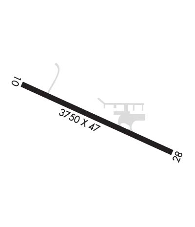
| Lat: N 3945.0 Long: W 08600.8 Elev: 861 Var: +02 Longest Runway: 3750 | ||
| CTAF: 122.9 | ||
| ||||||
|
| Rwy | Rwy | |||||||
| 3750x47 | 3750' | 3750x47 | 2481' | |||||
| Runway ID | Single Wheel | Double Wheel | Double Tandem Wheel | Dual Double Wheel |
| 10/28 | N/A | N/A | N/A | N/A |
| These numbers are Advisory and are not limits. The Airport Manager should have more accurate Weight Limits | ||||
| FltPlan does not have IFR approach charts available for K7L8. |
 Airport Diagram might not be current. | |
| Facility Name: | POST-AIR |
| City Name: | INDIANAPOLIS |
| County: | MARION |
| State abbrev: | IN |
| State Name: | INDIANA |
| Ownership: | PRIVATELY OWNED |
| Use: | OPEN TO THE PUBLIC |
| Owner's Name: | MARTIN FALL |
| Address: | 1215 S. FRANKLIN RD |
| INDIANAPOLIS, IN 46239 | |
| Owner's Phone: | 317-627-1308 |
| Manager's Name: | MARTIN FALL |
| Address: | 1215 S. FRANKLIN RD. |
| INDIANAPOLIS, IN 46239 | |
| Phone: | 317-627-1308 |
| FAA Region: | GREAT LAKES |
| FAA Field Office: | CHI |
| Date | Sunrise | Sunset |
|---|---|---|
| 09/24/21 Friday | 7:33 | 19:38 |
| 09/25/21 Saturday | 7:34 | 19:37 |
| 09/26/21 Sunday | 7:35 | 19:35 |
| 09/27/21 Monday | 7:36 | 19:33 |
| 09/28/21 Tuesday | 7:37 | 19:32 |
| 09/29/21 Wednesday | 7:38 | 19:30 |
| 09/30/21 Thursday | 7:39 | 19:28 |
| 10/01/21 Friday | 7:40 | 19:27 |
| 10/02/21 Saturday | 7:41 | 19:25 |
| 10/03/21 Sunday | 7:42 | 19:24 |
| 10/04/21 Monday | 7:43 | 19:22 |
| 10/05/21 Tuesday | 7:44 | 19:20 |
| 10/06/21 Wednesday | 7:45 | 19:19 |
| 10/07/21 Thursday | 7:46 | 19:17 |
| Airport Attendance Schedule | IRREGULAR |
| Airport Status | OPERATIONAL (This Status can change at any time - please check NOTAMS) |
| Airport Lighting Schedule | FOR LIRL RY 10/28 - CTAF |
| Airport Storage Available | NONE |
| Extra Services Available | NONE |
| Wind Indicator | YES - (unlit) |
| Control Tower | NO |
| CTAF Frequency | 122.900 |
| Unicom Frequency | |
| Rotating Beacon Color | |
| Segmented Circle | YES |
| Landing Fee |
| Airport Inspected | STATE - performed by STATE AERONAUTICAL PERSONNEL |
| Inspection Date | 02/02/2021 |
| Type of Fuel Available | None |
| Airframe Repair Service | None |
| Power Plant Repair Service | None |
| Latitude | N3945.0 |
| Longitude | W08600.8 (ESTIMATED) |
| Arpt Elevation | 861ft (SURVEYED) |
| Magnetic Variation | 02W |
| 6 miles E | of INDIANAPOLIS |
| Traffic Pattern Altitude | |
| Sectional Chart | ST LOUIS |
| Operations (Reported) | Yearly | Avg. Daily |
|---|---|---|
| General Aviation Transient | 210 | 1 |
| General Aviation Local | 1890 | 5 |
| Air Taxi | 0 | 0 |
| Commerical | 0 | 0 |
| Commuter | 0 | 0 |
| Military | 0 | 0 |
| Aircraft based on Field | |
|---|---|
| General Aviation Singles | 5 |
| General Aviation Multi | 0 |
| Jet Aircraft | 0 |
| General Aviation Helicopters | 0 |
| Military Aircraft | 0 |
| Gliders | 0 |
| Ultralights | 0 |
| FSS on field | NO |
| FSS tie-in | TERRE HAUTE |
| FSS Phone | 1-800-WX-BRIEF |
| Who issues Notams | HUF |
| Notam D service at airport | YES |
| ARTCC Name | INDIANAPOLIS |
| Airport Certification | |
| Aircraft Rescue & Firefighting Index | None |
| Airport of Entry | No |
| Custom Landing Rights | No |
| Joint Civil/Military | No |
| Military Landing rights | No |
| LGTD TV-TWR 2640'N OF APCH END RWY 28. |
| FOR CD CTC INDIANAPOLIS APCH AT 317-227-5743. |
| Runway: 10 | Runway: 28 | ||
| Mag heading: | N/A | Mag heading: | N/A |
| Rwy Slope: | .00% | Rwy Slope: | .00% |
| Approach: | Approach: | ||
| Pattern: | Right Traffic | Pattern: | Left Traffic |
| Markings: | BASIC | Markings: | BASIC |
| Marking Condition: | GOOD | Marking Condition: | GOOD |
| Arresting Dev: | Arresting Dev: | ||
| Lat & Long: | N3945.1 W08601.3 | Lat. & Long.: | N3945.0 W08600.5 |
| Elev: | 861.0 ft. MSL | Elev: | 861.0 ft. MSL |
| TCH: | TCH: | ||
| Visual Glide Path: | Visual Glide Path: | ||
| Displaced Threshold: | No | Displaced Threshold: | 1269 feet |
| Touchdown Zone: | NO | Touchdown Zone: | NO |
| Touchdown Elev.: | Touchdown Elev.: | ||
| Visual Glide Slope: | Visual Glide Slope: | ||
| RVR Equipment: | RVR Equipment: | ||
| RVV Equipment: | NO | RVV Equipment: | NO |
| Approach Lights: | Approach Lights: | ||
| REIL: | NO | REIL: | NO |
| Centerline Lights: | NO | Centerline Lights: | NO |
| Touchdown lights: | NO | Touchdown lights: | NO |
| Runway Category: | Runway with a Visual Approach | Runway Category: | Runway with a Visual Approach |
| Declared Distances: | Declared Distances: | ||
| Obstructions: | TREE | Obstructions: | TREES |
| Marked: | NOT Marked/Lighted | Marked: | NOT Marked/Lighted |
| Clearance slope: | 19:1 | Clearance slope: | APCH SLOPE 5:1 DUE TO 20 FT BLD 100 FT FM DSPLCD THLD, 125 FT R |
| Obstruction height: | 20 feet AGL | Obstruction height: | 45 feet AGL |
| Dist. from runway: | 595 feet | Dist. from runway: | 201 feet |
| Centerline offset: | 175 right of centerline | Centerline offset: | |
| Comments: | Comments: | HAS +25 FT PLINE; +15 FT ROAD; +25 FT HOUSE; 15-45 FT TREES 10-200 FT FM RWY END |
Thanks for using FltPlan.com
all rights reserved © 1999-2021 by Flight Plan LLC
