
| GEAUGA COUNTY MIDDLEFIELD OH |
| |
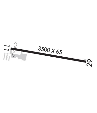
| Lat: N 4127.0 Long: W 08103.8 Elev: 1174 Var: +09 Longest Runway: 3500 | ||
| CTAF: 123.0 | ||
| ||||||||||||||||||||||||||||||||||||||||||||
| ||||||||||||||||||||||||||||||||||||||||||||
| Rwy | Rwy | |||||||
| 3500x65 | 3321' | 3500x65 | 3500' | |||||
| Runway ID | Single Wheel | Double Wheel | Double Tandem Wheel | Dual Double Wheel |
| 11/29 | 18,500 | N/A | N/A | N/A |
| These numbers are Advisory and are not limits. The Airport Manager should have more accurate Weight Limits | ||||
 Airport Diagram might not be current. | |
| Facility Name: | GEAUGA COUNTY |
| City Name: | MIDDLEFIELD |
| County: | GEAUGA |
| State abbrev: | OH |
| State Name: | OHIO |
| Ownership: | PUBLICLY OWNED |
| Use: | OPEN TO THE PUBLIC |
| Owner's Name: | GEAUGA CO BOARD OF COMM |
| Address: | COURTHOUSE ANNEX, 231 MAIN ST |
| CHARDON, OH 44024-1263 | |
| Owner's Phone: | 440-285-2222 |
| Manager's Name: | RICHARD BLAMER; 7G8MANAGER@GMAIL.COM. |
| Address: | PO BOX 1308 |
| MIDDLEFIELD, OH 44062-1308 | |
| Phone: | 440-632-1884; CELL 216-509-8858. |
| FAA Region: | GREAT LAKES |
| FAA Field Office: | DET |
| Date | Sunrise | Sunset |
|---|---|---|
| 06/08/26 Monday | 5:51 | 20:56 |
| 06/09/26 Tuesday | 5:50 | 20:57 |
| 06/10/26 Wednesday | 5:50 | 20:57 |
| 06/11/26 Thursday | 5:50 | 20:58 |
| 06/12/26 Friday | 5:50 | 20:58 |
| 06/13/26 Saturday | 5:50 | 20:59 |
| 06/14/26 Sunday | 5:50 | 20:59 |
| 06/15/26 Monday | 5:50 | 21:00 |
| 06/16/26 Tuesday | 5:50 | 21:00 |
| 06/17/26 Wednesday | 5:50 | 21:00 |
| 06/18/26 Thursday | 5:50 | 21:01 |
| 06/19/26 Friday | 5:50 | 21:01 |
| 06/20/26 Saturday | 5:50 | 21:01 |
| 06/21/26 Sunday | 5:51 | 21:01 |
| Airport Attendance Schedule | MON-FRI 0900-1700 IREG |
| Airport Status | OPERATIONAL (This Status can change at any time - please check NOTAMS) |
| Airport Lighting Schedule | ACTVT REIL RWY 11 & 29; PAPI RWY 29; MIRL RWY 11/29 - CTAF. |
| Airport Storage Available | Tie Downs, Hanger |
| Extra Services Available | Air Ambulance, Glider, Glider Towing |
| Wind Indicator | YES - (lighted) |
| Control Tower | NO |
| CTAF Frequency | 123.000 |
| Unicom Frequency | 123.000 |
| Rotating Beacon Color | WG |
| Segmented Circle | NO |
| Landing Fee | NO |
| Airport Inspected | STATE - performed by STATE AERONAUTICAL PERSONNEL |
| Inspection Date | 06/29/2023 |
| Type of Fuel Available | Grade 100LLMOGAS; -10100LL AVBL H24 VIA CREDIT CARD. |
| Airframe Repair Service | NONE |
| Power Plant Repair Service | NONE |
| Latitude | N4127.0 |
| Longitude | W08103.8 (ESTIMATED) |
| Arpt Elevation | 1174ft (SURVEYED) |
| Magnetic Variation | 09W |
| 1 miles SE | of MIDDLEFIELD |
| Traffic Pattern Altitude | 1025 |
| Sectional Chart | DETROIT |
| Operations (Reported) | Yearly | Avg. Daily |
|---|---|---|
| General Aviation Transient | 0 | 0 |
| General Aviation Local | 0 | 0 |
| Air Taxi | 0 | 0 |
| Commerical | 0 | 0 |
| Commuter | 0 | 0 |
| Military | 0 | 0 |
| Aircraft based on Field | |
|---|---|
| General Aviation Singles | 0 |
| General Aviation Multi | 0 |
| Jet Aircraft | 0 |
| General Aviation Helicopters | 0 |
| Military Aircraft | 0 |
| Gliders | 0 |
| Ultralights | 0 |
| FSS on field | NO |
| FSS tie-in | CLEVELAND |
| FSS Phone | 1-800-WX-BRIEF |
| Who issues Notams | CLE |
| Notam D service at airport | YES |
| ARTCC Name | CLEVELAND |
| Airport Certification | |
| Aircraft Rescue & Firefighting Index | None |
| Airport of Entry | No |
| Custom Landing Rights | No |
| Joint Civil/Military | No |
| Military Landing rights | No |
| NATIONAL PLAN OF INTEGRATED AIRPORT SYSTEMS (NPIAS) |
| PARL TWY EAST OF TEE HNGRS CLSD PERMLY. |
| EXTSV GLDR ACT ON & INVOF ARPT. |
| DEER, BIRDS, & OTR WILDLIFE ON & INVOF ARPT. |
| FOR CD CTC CLEVELAND APCH AT 216-352-2323. |
| ADZY ONLY WX AVBL - 4 CLICKS CTAF. |
Airport Communications & Frequencies:
| ||||||||||||||
| Runway: 11 | Runway: 29 | ||
| Mag heading: | 109° | Mag heading: | 289° |
| Rwy Slope: | -.47% Down | Rwy Slope: | .47% Up |
| Approach: | Approach: | ||
| Pattern: | Left Traffic | Pattern: | Left Traffic |
| Markings: | NONPRECISION INSTRUMENT | Markings: | NONPRECISION INSTRUMENT |
| Marking Condition: | GOOD | Marking Condition: | GOOD |
| Arresting Dev: | Arresting Dev: | ||
| Lat & Long: | N4127.0 W08104.2 | Lat. & Long.: | N4126.9 W08103.4 |
| Elev: | 1174.3 ft. MSL | Elev: | 1157.9 ft. MSL |
| TCH: | TCH: | 23 ft. AGL | |
| Visual Glide Path: | Visual Glide Path: | 3.00 degrees | |
| Displaced Threshold: | 179 feet | Displaced Threshold: | No |
| Touchdown Zone: | YES | Touchdown Zone: | YES |
| Touchdown Elev.: | 1172.0 feet | Touchdown Elev.: | 1167.1 feet |
| Visual Glide Slope: | Visual Glide Slope: | 2-Light PAPI on LEFT side of Runway | |
| RVR Equipment: | RVR Equipment: | ||
| RVV Equipment: | NO | RVV Equipment: | NO |
| Approach Lights: | Approach Lights: | ||
| REIL: | YES | REIL: | YES |
| Centerline Lights: | NO | Centerline Lights: | NO |
| Touchdown lights: | NO | Touchdown lights: | NO |
| Runway Category: | Runway with a Non-precision Approach | Runway Category: | Runway with a Non-precision Approach |
| Declared Distances: | Declared Distances: | ||
| Obstructions: | ANT | Obstructions: | |
| Marked: | LIGHTED | Marked: | |
| Clearance slope: | 7:1; APCH RATIO 16:1 TO DTHR. | Clearance slope: | 20:1 |
| Obstruction height: | 45 feet AGL | Obstruction height: | |
| Dist. from runway: | 551 feet | Dist. from runway: | |
| Centerline offset: | 160 right of centerline | Centerline offset: | |
| Comments: | +3-6 FT BRUSH, 0-140 FT DIST, 220 FT L. | Comments: |
Thanks for using FltPlan.com
all rights reserved © 1999-2026 by Flight Plan LLC
