
| LEDGEDALE AIRPARK BROCKPORT NY |
| |
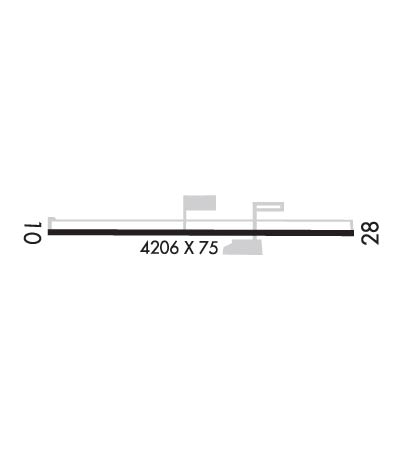
| Lat: N 4310.9 Long: W 07754.9 Elev: 665 Var: +11 Longest Runway: 4206 | ||
| CTAF: 122.7 | ||
| ||||||||||||||||||||||||||||||||||||||||||||
| ||||||||||||||||||||||||||||||||||||||||||||
| Rwy | Rwy | |||||||
| 4206x75 | 4206' | 4206x75 | 4206' | |||||
| Runway ID | Single Wheel | Double Wheel | Double Tandem Wheel | Dual Double Wheel |
| 10/28 | 12,000 | N/A | N/A | N/A |
| These numbers are Advisory and are not limits. The Airport Manager should have more accurate Weight Limits | ||||
 Airport Diagram might not be current. | |
| Facility Name: | LEDGEDALE AIRPARK |
| City Name: | BROCKPORT |
| County: | MONROE |
| State abbrev: | NY |
| State Name: | NEW YORK |
| Ownership: | PRIVATELY OWNED |
| Use: | OPEN TO THE PUBLIC |
| Owner's Name: | BIG FELLA ENTERPRIZES INC. |
| Address: | 21 EISENHAUER |
| BROCKPORT, NY 14420 | |
| Owner's Phone: | (585) 233-5117 |
| Manager's Name: | GRETCHEN PENNINGTON |
| Address: | 21 EISENHAUER |
| BROCKPORT, NY 14420 | |
| Phone: | (585) 233-5117 |
| FAA Region: | EASTERN |
| FAA Field Office: | NYC |
| Date | Sunrise | Sunset |
|---|---|---|
| 09/24/21 Friday | 7:01 | 19:06 |
| 09/25/21 Saturday | 7:02 | 19:04 |
| 09/26/21 Sunday | 7:03 | 19:02 |
| 09/27/21 Monday | 7:04 | 19:00 |
| 09/28/21 Tuesday | 7:05 | 18:59 |
| 09/29/21 Wednesday | 7:06 | 18:57 |
| 09/30/21 Thursday | 7:08 | 18:55 |
| 10/01/21 Friday | 7:09 | 18:53 |
| 10/02/21 Saturday | 7:10 | 18:51 |
| 10/03/21 Sunday | 7:11 | 18:50 |
| 10/04/21 Monday | 7:12 | 18:48 |
| 10/05/21 Tuesday | 7:13 | 18:46 |
| 10/06/21 Wednesday | 7:14 | 18:44 |
| 10/07/21 Thursday | 7:16 | 18:43 |
| Airport Attendance Schedule | 7 Days A Week 1000-1600; FOR ATTENDANCE OTHER HOURS MONDAY-FRIDAY CALL 585-233-5117. |
| Airport Status | OPERATIONAL (This Status can change at any time - please check NOTAMS) |
| Airport Lighting Schedule | |
| Airport Storage Available | Tie Downs, Hanger |
| Extra Services Available | Flight Instruction |
| Wind Indicator | YES - (lighted) |
| Control Tower | NO |
| CTAF Frequency | 122.700 |
| Unicom Frequency | 122.700 |
| Rotating Beacon Color | CLEAR-GREEN (Light Land Airport) |
| Segmented Circle | NO |
| Landing Fee | NO |
| Airport Inspected | STATE - performed by STATE AERONAUTICAL PERSONNEL |
| Inspection Date | 06/08/2021 |
| Type of Fuel Available | Grade 100LL, JET A (freeze point -40C) |
| Airframe Repair Service | MAJOR |
| Power Plant Repair Service | MAJOR |
| Latitude | N4310.9 |
| Longitude | W07754.9 (ESTIMATED) |
| Arpt Elevation | 664ft (SURVEYED) |
| Magnetic Variation | 11W |
| 3 miles SE | of BROCKPORT |
| Traffic Pattern Altitude | |
| Sectional Chart | DETROIT |
| Operations (Reported) | Yearly | Avg. Daily |
|---|---|---|
| General Aviation Transient | 1500 | 4 |
| General Aviation Local | 14000 | 38 |
| Air Taxi | 0 | 0 |
| Commerical | 0 | 0 |
| Commuter | 0 | 0 |
| Military | 600 | 2 |
| Aircraft based on Field | |
|---|---|
| General Aviation Singles | 29 |
| General Aviation Multi | 1 |
| Jet Aircraft | 0 |
| General Aviation Helicopters | 0 |
| Military Aircraft | 0 |
| Gliders | 0 |
| Ultralights | 0 |
| FSS on field | NO |
| FSS tie-in | BUFFALO |
| FSS Phone | 1-800-WX-BRIEF |
| Who issues Notams | BUF |
| Notam D service at airport | YES |
| ARTCC Name | CLEVELAND |
| Airport Certification | |
| Aircraft Rescue & Firefighting Index | None |
| Airport of Entry | No |
| Custom Landing Rights | No |
| Joint Civil/Military | No |
| Military Landing rights | No |
| NATIONAL PLAN OF INTEGRATED AIRPORT SYSTEMS (NPIAS) |
| ASSURANCES PURSUANT TO TITLE VI, CIVIL RIGHTS ACT OF 1964 |
| DEER ON & INVOF ARPT + MIGRATORY BIRDS ON ARPT IN SPRING AND FALL. |
| FOR CD CTC CLEVELAND ARTCC AT 440-774-0490. |
Airport Communications & Frequencies:
| ||||||||||||||
| Runway: 10 | Runway: 28 | ||
| Mag heading: | 102° | Mag heading: | 282° |
| Rwy Slope: | .15% Up | Rwy Slope: | -.15% Down |
| Approach: | Approach: | ||
| Pattern: | Left Traffic | Pattern: | Left Traffic |
| Markings: | NONPRECISION INSTRUMENT | Markings: | NONPRECISION INSTRUMENT |
| Marking Condition: | POOR; MARKINGS FADED | Marking Condition: | POOR; MARKINGS FADED |
| Arresting Dev: | Arresting Dev: | ||
| Lat & Long: | N4310.9 W07755.4 | Lat. & Long.: | N4310.9 W07754.5 |
| Elev: | 656.4 ft. MSL | Elev: | 662.5 ft. MSL |
| TCH: | TCH: | ||
| Visual Glide Path: | Visual Glide Path: | ||
| Displaced Threshold: | No | Displaced Threshold: | No |
| Touchdown Zone: | YES | Touchdown Zone: | YES |
| Touchdown Elev.: | 664.9 feet | Touchdown Elev.: | 664.9 feet |
| Visual Glide Slope: | Visual Glide Slope: | ||
| RVR Equipment: | RVR Equipment: | ||
| RVV Equipment: | NO | RVV Equipment: | NO |
| Approach Lights: | Approach Lights: | ||
| REIL: | NO | REIL: | NO |
| Centerline Lights: | NO | Centerline Lights: | NO |
| Touchdown lights: | NO | Touchdown lights: | NO |
| Runway Category: | Runway with a Visual Approach | Runway Category: | Runway with a Non-precision Approach |
| Declared Distances: | Declared Distances: | ||
| Obstructions: | BRUSH | Obstructions: | TREES; RY 28 HAS TREES ON BOTH SIDES OF CNTRLN, +32 TO +50 FT HIGH, 750 - 900 FT FROM RY END |
| Marked: | NOT Marked/Lighted | Marked: | NOT Marked/Lighted |
| Clearance slope: | 5:1 | Clearance slope: | 15:1 |
| Obstruction height: | 18 feet AGL | Obstruction height: | 37 feet AGL |
| Dist. from runway: | 292 feet | Dist. from runway: | 759 feet |
| Centerline offset: | Centerline offset: | 148 feet left of centerline | |
| Comments: | RWY 10, +5 FT ELECTRICAL BOXES 81 FT OUT AND 100 FT LEFT; +11 TO +16FT TREES, 104 -160FT FRM RWY, 172 - 183FT RT. | Comments: | RY 28 HAS +5 FT ELECTRIC BOXES 61 FT FM RY END AND 100 FT RIGHT; +20 TO +33FT TREES, 13 - 32FT FRM RNWY,114 - 123FT LEFT. |
Thanks for using FltPlan.com
all rights reserved © 1999-2021 by Flight Plan LLC
