
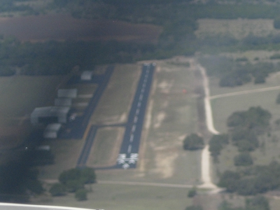
| CLIFTON MUNI/ISENHOWER FIELD CLIFTON TX |
| |
| Lat: N 3149.0 Long: W 09734.2 Elev: 760 Var: -07 Longest Runway: 3000 | ||
| CTAF: 122.8 | ||
| ||||||||||||||||||||||||||||||||||||||||||||
| ||||||||||||||||||||||||||||||||||||||||||||
| Rwy | Rwy | |||||||
| 3000x50 | 3000' | 3000x50 | 2850' | |||||
| Runway ID | Single Wheel | Double Wheel | Double Tandem Wheel | Dual Double Wheel |
| 14/32 | 13,000 | N/A | N/A | N/A |
| These numbers are Advisory and are not limits. The Airport Manager should have more accurate Weight Limits | ||||
| FltPlan does not have IFR approach charts available for K7F7. |
| Facility Name: | CLIFTON MUNI/ISENHOWER FLD |
| City Name: | CLIFTON |
| County: | BOSQUE |
| State abbrev: | TX |
| State Name: | TEXAS |
| Ownership: | PUBLICLY OWNED |
| Use: | OPEN TO THE PUBLIC |
| Owner's Name: | CITY OF CLIFTON |
| Address: | 492 THIRD ST., PO BOX 231 |
| CLIFTON, TX 76634 | |
| Owner's Phone: | 254-675-8337 |
| Manager's Name: | TIM TALLEY |
| Address: | PO BOX 249 |
| CLIFTON, TX 76634 | |
| Phone: | 254-675-3771 |
| FAA Region: | SOUTHWEST |
| FAA Field Office: | TEX |
| Date | Sunrise | Sunset |
|---|---|---|
| 06/12/26 Friday | 6:24 | 20:36 |
| 06/13/26 Saturday | 6:24 | 20:37 |
| 06/14/26 Sunday | 6:24 | 20:37 |
| 06/15/26 Monday | 6:24 | 20:37 |
| 06/16/26 Tuesday | 6:24 | 20:38 |
| 06/17/26 Wednesday | 6:24 | 20:38 |
| 06/18/26 Thursday | 6:25 | 20:38 |
| 06/19/26 Friday | 6:25 | 20:38 |
| 06/20/26 Saturday | 6:25 | 20:39 |
| 06/21/26 Sunday | 6:25 | 20:39 |
| 06/22/26 Monday | 6:25 | 20:39 |
| 06/23/26 Tuesday | 6:26 | 20:39 |
| 06/24/26 Wednesday | 6:26 | 20:39 |
| 06/25/26 Thursday | 6:26 | 20:40 |
| Airport Attendance Schedule | MON-FRI 0800-1630; FOR ARPT ATTENDANT ON SAT & SUN CALL 254-978-0020 OR 254-253-0859; AFT HR FEE. |
| Airport Status | OPERATIONAL (This Status can change at any time - please check NOTAMS) |
| Airport Lighting Schedule | SS-SR MIRL RWY 14/32 PRESET LOW INTST; TO INCR INTST - CTAF. |
| Airport Storage Available | Tie Downs, Hanger |
| Extra Services Available | Crop Dusting, Flight Instruction |
| Wind Indicator | YES - (lighted) |
| Control Tower | NO |
| CTAF Frequency | 122.800 |
| Unicom Frequency | 122.800 |
| Rotating Beacon Color | WG |
| Segmented Circle | YES |
| Landing Fee | NO |
| Airport Inspected | STATE - performed by PRIVATE CONTRACT PERSONNEL |
| Inspection Date | 11/08/2024 |
| Type of Fuel Available | Grade 100LL |
| Airframe Repair Service | MAJOR |
| Power Plant Repair Service | MAJOR |
| Latitude | N3149.0 |
| Longitude | W09734.2 (ESTIMATED) |
| Arpt Elevation | 760ft (ESTIMATED) |
| Magnetic Variation | 07E |
| 2 miles N | of CLIFTON |
| Traffic Pattern Altitude | |
| Sectional Chart | SAN ANTONIO |
| Operations (Reported) | Yearly | Avg. Daily |
|---|---|---|
| General Aviation Transient | 0 | 0 |
| General Aviation Local | 0 | 0 |
| Air Taxi | 0 | 0 |
| Commerical | 0 | 0 |
| Commuter | 0 | 0 |
| Military | 0 | 0 |
| Aircraft based on Field | |
|---|---|
| General Aviation Singles | 0 |
| General Aviation Multi | 0 |
| Jet Aircraft | 0 |
| General Aviation Helicopters | 0 |
| Military Aircraft | 0 |
| Gliders | 0 |
| Ultralights | 0 |
| FSS on field | NO |
| FSS tie-in | FORT WORTH |
| FSS Phone | 1-800-WX-BRIEF |
| Who issues Notams | FTW |
| Notam D service at airport | YES |
| ARTCC Name | FORT WORTH |
| Airport Certification | |
| Aircraft Rescue & Firefighting Index | None |
| Airport of Entry | No |
| Custom Landing Rights | No |
| Joint Civil/Military | No |
| Military Landing rights | No |
| NATIONAL PLAN OF INTEGRATED AIRPORT SYSTEMS (NPIAS) |
| STEEP DROP OFF NORTH OF RWY 14. |
| SECURITY GATE LOCKED AFTER HRS. FOR ACCESS CONTACT 254-675-6620. |
| FOR CD CTC FORT WORTH ARTCC AT 817-858-7584. |
| NO LINE OF SIGHT BETWEEN RWY ENDS. |
| Runway: 14 | Runway: 32 | ||
| Mag heading: | 142° | Mag heading: | 322° |
| Rwy Slope: | -.27% Down | Rwy Slope: | .27% Up |
| Approach: | Approach: | ||
| Pattern: | Left Traffic | Pattern: | Left Traffic |
| Markings: | BASIC | Markings: | BASIC |
| Marking Condition: | GOOD | Marking Condition: | GOOD |
| Arresting Dev: | Arresting Dev: | ||
| Lat & Long: | N3149.2 W09734.3 | Lat. & Long.: | N3148.8 W09734.0 |
| Elev: | 756.0 ft. MSL | Elev: | 748.0 ft. MSL |
| TCH: | 30 ft. AGL | TCH: | 30 ft. AGL |
| Visual Glide Path: | 3.00 degrees | Visual Glide Path: | 3.00 degrees |
| Displaced Threshold: | No | Displaced Threshold: | 150 feet |
| Touchdown Zone: | NO | Touchdown Zone: | NO |
| Touchdown Elev.: | Touchdown Elev.: | ||
| Visual Glide Slope: | 2-Light PAPI on LEFT side of Runway | Visual Glide Slope: | 2-Light PAPI on RIGHT side of Runway |
| RVR Equipment: | RVR Equipment: | ||
| RVV Equipment: | NO | RVV Equipment: | NO |
| Approach Lights: | Approach Lights: | ||
| REIL: | NO | REIL: | NO |
| Centerline Lights: | NO | Centerline Lights: | NO |
| Touchdown lights: | NO | Touchdown lights: | NO |
| Runway Category: | Runway with a Visual Approach | Runway Category: | Runway with a Visual Approach |
| Declared Distances: | Declared Distances: | ||
| Obstructions: | Obstructions: | TREES | |
| Marked: | Marked: | NOT Marked/Lighted | |
| Clearance slope: | 20:1 | Clearance slope: | APCH SLOPE 10:1 TO DSPLCD THR OVR 32 FT TREE, 340 FT DSTC, 115 FT L. |
| Obstruction height: | Obstruction height: | 32 feet AGL | |
| Dist. from runway: | Dist. from runway: | 201 feet | |
| Centerline offset: | Centerline offset: | 115 feet left of centerline | |
| Comments: | Comments: | 8 FT FENCE, 43-199 FT DSTC, ACRS APCH. |
Thanks for using FltPlan.com
all rights reserved © 1999-2026 by Flight Plan LLC