
| BALDWIN MUNI BALDWIN MI |
| |
| Lat: N 4352.5 Long: W 08550.5 Elev: 828 Var: +06 Longest Runway: 3800 | ||
| CTAF: 122.9 | ||
| ||||||||||||||||||||||||||||||||
| ||||||||||||||||||||||||||||||||
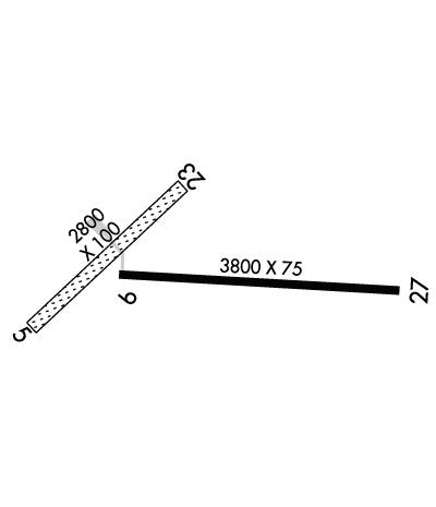
| Rwy | Rwy | |||||||
| 2800x100 | 2000' | 2800x100 | 2000' | |||||
| 3800x75 | 3800' | 3800x75 | 3800' | |||||
| Runway ID | Single Wheel | Double Wheel | Double Tandem Wheel | Dual Double Wheel |
| 05/23 | N/A | N/A | N/A | N/A |
| 09/27 | 10,000 | N/A | N/A | N/A |
| These numbers are Advisory and are not limits. The Airport Manager should have more accurate Weight Limits | ||||
 Airport Diagram might not be current. | |
| Facility Name: | BALDWIN MUNI |
| City Name: | BALDWIN |
| County: | LAKE |
| State abbrev: | MI |
| State Name: | MICHIGAN |
| Ownership: | PUBLICLY OWNED |
| Use: | OPEN TO THE PUBLIC |
| Owner's Name: | VILLAGE OF BALDWIN |
| Address: | PO BOX 339 |
| BALDWIN, MI 49304-0339 | |
| Owner's Phone: | 231-745-3587 |
| Manager's Name: | MAC L MCCLELLAN |
| Address: | 7668 S M-37 |
| BALDWIN, MI 49304 | |
| Phone: | 231-745-7815; CELL 231-250-2551. |
| FAA Region: | GREAT LAKES |
| FAA Field Office: | DET |
| Date | Sunrise | Sunset |
|---|---|---|
| 06/07/26 Sunday | 6:02 | 21:23 |
| 06/08/26 Monday | 6:01 | 21:24 |
| 06/09/26 Tuesday | 6:01 | 21:24 |
| 06/10/26 Wednesday | 6:01 | 21:25 |
| 06/11/26 Thursday | 6:01 | 21:25 |
| 06/12/26 Friday | 6:00 | 21:26 |
| 06/13/26 Saturday | 6:00 | 21:27 |
| 06/14/26 Sunday | 6:00 | 21:27 |
| 06/15/26 Monday | 6:00 | 21:27 |
| 06/16/26 Tuesday | 6:00 | 21:28 |
| 06/17/26 Wednesday | 6:00 | 21:28 |
| 06/18/26 Thursday | 6:00 | 21:28 |
| 06/19/26 Friday | 6:01 | 21:29 |
| 06/20/26 Saturday | 6:01 | 21:29 |
| Airport Attendance Schedule | UNATTENDED |
| Airport Status | OPERATIONAL (This Status can change at any time - please check NOTAMS) |
| Airport Lighting Schedule | |
| Airport Storage Available | Tie Downs |
| Extra Services Available | NONE |
| Wind Indicator | YES - (unlit) |
| Control Tower | NO |
| CTAF Frequency | 122.900 |
| Unicom Frequency | |
| Rotating Beacon Color | |
| Segmented Circle | YES |
| Landing Fee | NO |
| Airport Inspected | STATE - performed by STATE AERONAUTICAL PERSONNEL |
| Inspection Date | 07/25/2023 |
| Type of Fuel Available | None |
| Airframe Repair Service | NONE |
| Power Plant Repair Service | NONE |
| Latitude | N4352.5 |
| Longitude | W08550.5 (ESTIMATED) |
| Arpt Elevation | 828ft (ESTIMATED) |
| Magnetic Variation | 06W |
| 2 miles S | of BALDWIN |
| Traffic Pattern Altitude | |
| Sectional Chart | CHICAGO |
| Operations (Reported) | Yearly | Avg. Daily |
|---|---|---|
| General Aviation Transient | 0 | 0 |
| General Aviation Local | 0 | 0 |
| Air Taxi | 0 | 0 |
| Commerical | 0 | 0 |
| Commuter | 0 | 0 |
| Military | 0 | 0 |
| Aircraft based on Field | |
|---|---|
| General Aviation Singles | 0 |
| General Aviation Multi | 0 |
| Jet Aircraft | 0 |
| General Aviation Helicopters | 0 |
| Military Aircraft | 0 |
| Gliders | 0 |
| Ultralights | 0 |
| FSS on field | NO |
| FSS tie-in | LANSING |
| FSS Phone | 1-800-WX-BRIEF |
| Who issues Notams | LAN |
| Notam D service at airport | YES |
| ARTCC Name | MINNEAPOLIS |
| Airport Certification | |
| Aircraft Rescue & Firefighting Index | None |
| Airport of Entry | No |
| Custom Landing Rights | No |
| Joint Civil/Military | No |
| Military Landing rights | YES |
| GRANT AGREEMENTS UNDER FAAP/ADAP/AIP |
| CONVEYANCE UNDER SCETION 16, FEDERAL AIRPORT ACT OF 1946 OR SECTION 23, AIRPORT AND AIRWAY DEVELOPMENT ACT OF 1970 |
| ASSURANCES PURSUANT TO TITLE VI, CIVIL RIGHTS ACT OF 1964 |
| THIS AIRPORT HAS BEEN SURVEYED BY THE NATIONAL GEODETIC SURVEY. |
| DEER ON & INVOF ARPT. |
| UAS OPS ADJ TO RWY 09/27. |
| GATE 5-3-2-1. |
| FOR CD CTC MINNEAPOLIS ARTCC AT 651-463-5588. |
| ARPT CLSD WHEN SNOW COVD - NO SNOW REMOVAL. |
Airport Communications & Frequencies:
| |||||||
| Runway: 05 | Runway: 23 | ||
| Mag heading: | 53° | Mag heading: | 233° |
| Rwy Slope: | .21% Up | Rwy Slope: | -.21% Down |
| Approach: | Approach: | ||
| Pattern: | Left Traffic | Pattern: | Left Traffic |
| Markings: | Markings: | ||
| Marking Condition: | RWY & DTHR MKD WITH 3 FT YELLOW CONES. | Marking Condition: | RWY & DTHR MKD WITH 3 FT YELLOW CONES. |
| Arresting Dev: | Arresting Dev: | ||
| Lat & Long: | N4352.4 W08551.0 | Lat. & Long.: | N4352.7 W08550.6 |
| Elev: | 816.0 ft. MSL | Elev: | 822.0 ft. MSL |
| TCH: | TCH: | ||
| Visual Glide Path: | Visual Glide Path: | ||
| Displaced Threshold: | 800 feet | Displaced Threshold: | 800 feet |
| Touchdown Zone: | YES | Touchdown Zone: | YES |
| Touchdown Elev.: | 822.0 feet | Touchdown Elev.: | 822.0 feet |
| Visual Glide Slope: | Visual Glide Slope: | ||
| RVR Equipment: | RVR Equipment: | ||
| RVV Equipment: | NO | RVV Equipment: | NO |
| Approach Lights: | Approach Lights: | ||
| REIL: | NO | REIL: | NO |
| Centerline Lights: | NO | Centerline Lights: | NO |
| Touchdown lights: | NO | Touchdown lights: | NO |
| Runway Category: | Runway with a Visual Approach | Runway Category: | Runway with a Visual Approach |
| Declared Distances: | Declared Distances: | ||
| Obstructions: | TREES | Obstructions: | ROAD |
| Marked: | NOT Marked/Lighted | Marked: | NOT Marked/Lighted |
| Clearance slope: | 7:1 | Clearance slope: | 17:1 |
| Obstruction height: | 63 feet AGL | Obstruction height: | 15 feet AGL |
| Dist. from runway: | 470 feet | Dist. from runway: | 267 feet |
| Centerline offset: | 140 left of centerline | Centerline offset: | 77 feet left of centerline |
| Comments: | Comments: |
| Runway: 09 | Runway: 27 | ||
| Mag heading: | 100° | Mag heading: | 280° |
| Rwy Slope: | .26% Up | Rwy Slope: | -.26% Down |
| Approach: | Approach: | ||
| Pattern: | Left Traffic | Pattern: | Left Traffic |
| Markings: | BASIC | Markings: | BASIC |
| Marking Condition: | GOOD | Marking Condition: | GOOD |
| Arresting Dev: | Arresting Dev: | ||
| Lat & Long: | N4352.5 W08550.8 | Lat. & Long.: | N4352.5 W08549.9 |
| Elev: | 818.0 ft. MSL | Elev: | 828.0 ft. MSL |
| TCH: | TCH: | ||
| Visual Glide Path: | Visual Glide Path: | ||
| Displaced Threshold: | No | Displaced Threshold: | No |
| Touchdown Zone: | YES | Touchdown Zone: | YES |
| Touchdown Elev.: | 826.0 feet | Touchdown Elev.: | 828.0 feet |
| Visual Glide Slope: | Visual Glide Slope: | ||
| RVR Equipment: | RVR Equipment: | ||
| RVV Equipment: | NO | RVV Equipment: | NO |
| Approach Lights: | Approach Lights: | ||
| REIL: | NO | REIL: | NO |
| Centerline Lights: | NO | Centerline Lights: | NO |
| Touchdown lights: | NO | Touchdown lights: | NO |
| Runway Category: | Runway with a Visual Approach | Runway Category: | Runway with a Visual Approach |
| Declared Distances: | Declared Distances: | ||
| Obstructions: | Obstructions: | TREES | |
| Marked: | Marked: | NOT Marked/Lighted | |
| Clearance slope: | 20:1 | Clearance slope: | 14:1 |
| Obstruction height: | Obstruction height: | 80 feet AGL | |
| Dist. from runway: | Dist. from runway: | 1382 feet | |
| Centerline offset: | Centerline offset: | 300 feet right of centerline | |
| Comments: | Comments: |
Thanks for using FltPlan.com
all rights reserved © 1999-2026 by Flight Plan LLC
