
| LANETT MUNI LANETT AL |
| |
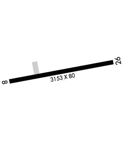
| Lat: N 3248.7 Long: W 08513.8 Elev: 631 Var: +05 Longest Runway: 5400 | ||
| CTAF: 122.8 | ||
| ||||||||||||||||||||||||||||||||||||||||||||
| ||||||||||||||||||||||||||||||||||||||||||||
| Rwy | Rwy | |||||||
| 5400x75 | 5400' | 5400x75 | 5400' | |||||
| Runway ID | Single Wheel | Double Wheel | Double Tandem Wheel | Dual Double Wheel |
| 06/24 | N/A | N/A | N/A | N/A |
| These numbers are Advisory and are not limits. The Airport Manager should have more accurate Weight Limits | ||||
 Airport Diagram might not be current. | |
| Facility Name: | LANETT RGNL |
| City Name: | LANETT |
| County: | CHAMBERS |
| State abbrev: | AL |
| State Name: | ALABAMA |
| Ownership: | PUBLICLY OWNED |
| Use: | OPEN TO THE PUBLIC |
| Owner's Name: | CITY OF LANETT |
| Address: | 401 N. LANIER AVE, 4445 51ST AVE SW |
| LANETT, AL 36863 | |
| Owner's Phone: | 334-644-2141 |
| Manager's Name: | CRAIG STAPLETON |
| Address: | 4445 51ST AVE SW, PO BOX 290 |
| LANETT, AL 36863 | |
| Phone: | 334-476-3184; 334-476-3184 |
| FAA Region: | SOUTHERN |
| FAA Field Office: | JAN |

| Date | Sunrise | Sunset |
|---|---|---|
| 06/07/26 Sunday | 5:32 | 19:47 |
| 06/08/26 Monday | 5:32 | 19:48 |
| 06/09/26 Tuesday | 5:32 | 19:48 |
| 06/10/26 Wednesday | 5:32 | 19:49 |
| 06/11/26 Thursday | 5:32 | 19:49 |
| 06/12/26 Friday | 5:32 | 19:49 |
| 06/13/26 Saturday | 5:32 | 19:50 |
| 06/14/26 Sunday | 5:32 | 19:50 |
| 06/15/26 Monday | 5:32 | 19:50 |
| 06/16/26 Tuesday | 5:32 | 19:51 |
| 06/17/26 Wednesday | 5:32 | 19:51 |
| 06/18/26 Thursday | 5:33 | 19:51 |
| 06/19/26 Friday | 5:33 | 19:52 |
| 06/20/26 Saturday | 5:33 | 19:52 |
| Airport Attendance Schedule | ATTENDED 7 Days A Week 0800-1700 |
| Airport Status | OPERATIONAL (This Status can change at any time - please check NOTAMS) |
| Airport Lighting Schedule | ACTVT REIL RWY 06 & 24; MIRL RWY 06/24 - CTAF. |
| Airport Storage Available | Tie Downs |
| Extra Services Available | Flight Instruction |
| Wind Indicator | YES - (lighted) |
| Control Tower | NO |
| CTAF Frequency | 122.800 |
| Unicom Frequency | 122.800 |
| Rotating Beacon Color | WG |
| Segmented Circle | YES |
| Landing Fee | NO |
| Airport Inspected | STATE - performed by STATE AERONAUTICAL PERSONNEL |
| Inspection Date | 04/23/2025 |
| Type of Fuel Available | Grade 100LL; -10FUEL 24 HR CREDIT CARD SVC AVBL. |
| Airframe Repair Service | NONE |
| Power Plant Repair Service | NONE |
| Latitude | N3248.7 |
| Longitude | W08513.8 (ESTIMATED) |
| Arpt Elevation | 630ft (SURVEYED) |
| Magnetic Variation | 05W |
| 3 miles SW | of LANETT |
| Traffic Pattern Altitude | |
| Sectional Chart | ATLANTA |
| Operations (Reported) | Yearly | Avg. Daily |
|---|---|---|
| General Aviation Transient | 0 | 0 |
| General Aviation Local | 0 | 0 |
| Air Taxi | 0 | 0 |
| Commerical | 0 | 0 |
| Commuter | 0 | 0 |
| Military | 0 | 0 |
| Aircraft based on Field | |
|---|---|
| General Aviation Singles | 0 |
| General Aviation Multi | 0 |
| Jet Aircraft | 0 |
| General Aviation Helicopters | 0 |
| Military Aircraft | 0 |
| Gliders | 0 |
| Ultralights | 0 |
| FSS on field | NO |
| FSS tie-in | ANNISTON |
| FSS Phone | 1-800-WX-BRIEF |
| Who issues Notams | ANB |
| Notam D service at airport | YES |
| ARTCC Name | ATLANTA |
| Airport Certification | |
| Aircraft Rescue & Firefighting Index | None |
| Airport of Entry | No |
| Custom Landing Rights | No |
| Joint Civil/Military | No |
| Military Landing rights | No |
| NATIONAL PLAN OF INTEGRATED AIRPORT SYSTEMS (NPIAS) |
| GRANT AGREEMENTS UNDER FAAP/ADAP/AIP |
| ASSURANCES PURSUANT TO TITLE VI, CIVIL RIGHTS ACT OF 1964 |
| AGREEMENT UNDER DLAND OR DCLA HAS EXPIRED. |
| DEER ON & INVOF ARPT. |
| FOR CD CTC ATLANTA APCH AT 678-364-6132, WHEN APCH CLSD CTC ATLANTA ARTCC AT 770-210-7692. |
Airport Communications & Frequencies:
| |||||||||||||||||||||
| Runway: 06 | Runway: 24 | ||
| Mag heading: | 57° | Mag heading: | 237° |
| Rwy Slope: | .44% Up | Rwy Slope: | -.44% Down |
| Approach: | Approach: | ||
| Pattern: | Left Traffic | Pattern: | Left Traffic |
| Markings: | BASIC | Markings: | BASIC |
| Marking Condition: | GOOD | Marking Condition: | GOOD |
| Arresting Dev: | Arresting Dev: | ||
| Lat & Long: | N3248.4 W08514.2 | Lat. & Long.: | N3249.0 W08513.4 |
| Elev: | 607.2 ft. MSL | Elev: | 630.9 ft. MSL |
| TCH: | TCH: | ||
| Visual Glide Path: | Visual Glide Path: | ||
| Displaced Threshold: | No | Displaced Threshold: | No |
| Touchdown Zone: | YES | Touchdown Zone: | YES |
| Touchdown Elev.: | 622.8 feet | Touchdown Elev.: | 630.9 feet |
| Visual Glide Slope: | Visual Glide Slope: | ||
| RVR Equipment: | RVR Equipment: | ||
| RVV Equipment: | NO | RVV Equipment: | NO |
| Approach Lights: | Approach Lights: | ||
| REIL: | YES | REIL: | YES |
| Centerline Lights: | NO | Centerline Lights: | NO |
| Touchdown lights: | NO | Touchdown lights: | NO |
| Runway Category: | Runway with a Non-precision Approach having visibility minimums greater than 3/4 mile | Runway Category: | Runway with a Non-precision Approach having visibility minimums greater than 3/4 mile |
| Declared Distances: | Declared Distances: | ||
| Obstructions: | FENCE | Obstructions: | TREE |
| Marked: | NOT Marked/Lighted | Marked: | NOT Marked/Lighted |
| Clearance slope: | 17:1 | Clearance slope: | 9:1 |
| Obstruction height: | 60 feet AGL | Obstruction height: | 10 feet AGL |
| Dist. from runway: | 1231 feet | Dist. from runway: | 293 feet |
| Centerline offset: | 292 right of centerline | Centerline offset: | 107 feet right of centerline |
| Comments: | Comments: |
Thanks for using FltPlan.com
all rights reserved © 1999-2026 by Flight Plan LLC