
| MARINE CITY MARINE CITY MI |
| |
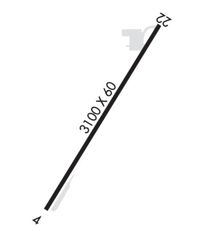
| Lat: N 4243.3 Long: W 08235.8 Elev: 613 Var: +06 Longest Runway: 3100 | ||
| CTAF: 123.0 | ||
| ||||||
|
| Rwy | Rwy | |||||||
| 3100x60 | 3100' | 3100x60 | 2805' | |||||
| Runway ID | Single Wheel | Double Wheel | Double Tandem Wheel | Dual Double Wheel |
| 04/22 | N/A | N/A | N/A | N/A |
| These numbers are Advisory and are not limits. The Airport Manager should have more accurate Weight Limits | ||||
| FltPlan does not have IFR approach charts available for K76G. |
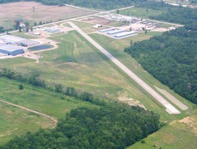
 Airport Diagram might not be current. | |
| Facility Name: | MARINE CITY |
| City Name: | MARINE CITY |
| County: | ST CLAIR |
| State abbrev: | MI |
| State Name: | MICHIGAN |
| Ownership: | PRIVATELY OWNED |
| Use: | OPEN TO THE PUBLIC |
| Owner's Name: | WILLIS MANTER |
| Address: | 7115 MARINE CITY HWY |
| MARINE CITY, MI 48039 | |
| Owner's Phone: | 810-765-8289 |
| Manager's Name: | NANCY MANTER |
| Address: | 7115 MARINE CITY HWY |
| MARINE CITY, MI 48039 | |
| Phone: | 810-765-8289 |
| FAA Region: | GREAT LAKES |
| FAA Field Office: | DET |
| Date | Sunrise | Sunset |
|---|---|---|
| 09/24/21 Friday | 7:20 | 19:25 |
| 09/25/21 Saturday | 7:21 | 19:23 |
| 09/26/21 Sunday | 7:22 | 19:21 |
| 09/27/21 Monday | 7:23 | 19:19 |
| 09/28/21 Tuesday | 7:24 | 19:17 |
| 09/29/21 Wednesday | 7:25 | 19:16 |
| 09/30/21 Thursday | 7:26 | 19:14 |
| 10/01/21 Friday | 7:27 | 19:12 |
| 10/02/21 Saturday | 7:28 | 19:10 |
| 10/03/21 Sunday | 7:30 | 19:09 |
| 10/04/21 Monday | 7:31 | 19:07 |
| 10/05/21 Tuesday | 7:32 | 19:05 |
| 10/06/21 Wednesday | 7:33 | 19:03 |
| 10/07/21 Thursday | 7:34 | 19:02 |
| Airport Attendance Schedule | 7 Days A Week UNATTENDED; FOR AIRPORT SERVICES CALL 810-650-7519 |
| Airport Status | OPERATIONAL (This Status can change at any time - please check NOTAMS) |
| Airport Lighting Schedule | SS-SR |
| Airport Storage Available | Tie Downs, Hanger |
| Extra Services Available | Flight Instruction, Aircraft Rental |
| Wind Indicator | YES - (lighted) |
| Control Tower | NO |
| CTAF Frequency | 123.000 |
| Unicom Frequency | 123.000 |
| Rotating Beacon Color | CLEAR-GREEN (Light Land Airport) |
| Segmented Circle | YES |
| Landing Fee |
| Airport Inspected | STATE - performed by STATE AERONAUTICAL PERSONNEL |
| Inspection Date | 05/11/2017 |
| Type of Fuel Available | Grade 100LL |
| Airframe Repair Service | MAJOR |
| Power Plant Repair Service | MAJOR |
| Latitude | N4243.3 |
| Longitude | W08235.8 (ESTIMATED) |
| Arpt Elevation | 613ft (ESTIMATED) |
| Magnetic Variation | 06W |
| 4 miles W | of MARINE CITY |
| Traffic Pattern Altitude | |
| Sectional Chart | DETROIT |
| Operations (Reported) | Yearly | Avg. Daily |
|---|---|---|
| General Aviation Transient | 4000 | 11 |
| General Aviation Local | 4000 | 11 |
| Air Taxi | 0 | 0 |
| Commerical | 0 | 0 |
| Commuter | 0 | 0 |
| Military | 0 | 0 |
| Aircraft based on Field | |
|---|---|
| General Aviation Singles | 24 |
| General Aviation Multi | 2 |
| Jet Aircraft | 0 |
| General Aviation Helicopters | 0 |
| Military Aircraft | 0 |
| Gliders | 0 |
| Ultralights | 0 |
| FSS on field | NO |
| FSS tie-in | LANSING |
| FSS Phone | 1-800-WX-BRIEF |
| Who issues Notams | LAN |
| Notam D service at airport | YES |
| ARTCC Name | CLEVELAND |
| Airport Certification | |
| Aircraft Rescue & Firefighting Index | None |
| Airport of Entry | No |
| Custom Landing Rights | No |
| Joint Civil/Military | No |
| Military Landing rights | No |
| FOR IFR CLEARANCE CTC SELFRIDGE RAPCON 0700-2300 LCL 119.6 OR CALL 586-239-5706, AND CLEVELAND CENTER 2300-0700 LCL 132.25 OR CALL 440-774-0448. |
| RWY 04/2 2 NSTD MIRL LOCATED 23 FT FM RY EDGE. |
| Runway: 04 | Runway: 22 | ||
| Mag heading: | 38° | Mag heading: | 218° |
| Rwy Slope: | .04% Up | Rwy Slope: | -.04% Down |
| Approach: | Approach: | ||
| Pattern: | Left Traffic | Pattern: | Left Traffic |
| Markings: | BASIC | Markings: | BASIC |
| Marking Condition: | FAIR | Marking Condition: | FAIR |
| Arresting Dev: | Arresting Dev: | ||
| Lat & Long: | N4243.1 W08236.0 | Lat. & Long.: | N4243.5 W08235.6 |
| Elev: | 611.8 ft. MSL | Elev: | 613.0 ft. MSL |
| TCH: | 25 ft. AGL | TCH: | 25 ft. AGL |
| Visual Glide Path: | 4.00 degrees | Visual Glide Path: | 4.00 degrees |
| Displaced Threshold: | No | Displaced Threshold: | 295 feet |
| Touchdown Zone: | NO | Touchdown Zone: | NO |
| Touchdown Elev.: | Touchdown Elev.: | ||
| Visual Glide Slope: | 2-Light PAPI on LEFT side of Runway | Visual Glide Slope: | 2-Light PAPI on LEFT side of Runway |
| RVR Equipment: | RVR Equipment: | ||
| RVV Equipment: | NO | RVV Equipment: | NO |
| Approach Lights: | Approach Lights: | ||
| REIL: | YES | REIL: | NO |
| Centerline Lights: | NO | Centerline Lights: | NO |
| Touchdown lights: | NO | Touchdown lights: | NO |
| Runway Category: | Runway with a Visual Approach | Runway Category: | Runway with a Visual Approach |
| Declared Distances: | Declared Distances: | ||
| Obstructions: | PLINE | Obstructions: | BRUSH |
| Marked: | NOT Marked/Lighted | Marked: | NOT Marked/Lighted |
| Clearance slope: | 18:1; APCH RATIO 20:1 AT THRESHOLD. | Clearance slope: | APCH RATIO 24:1 TO DSPLCD THR; +60' TREES 1446 FT STC, 0B. |
| Obstruction height: | 100 feet AGL | Obstruction height: | 10 feet AGL |
| Dist. from runway: | 2000 feet | Dist. from runway: | 201 feet |
| Centerline offset: | Centerline offset: | ||
| Comments: | Comments: | +15' ROAD AT THLD 125' R; +10' BRUSH/TREES 186' FROM THLD, +15 FT ROAD 130 FT L. |
Thanks for using FltPlan.com
all rights reserved © 1999-2021 by Flight Plan LLC