
| BLACKWELL FIELD OZARK AL |
| |
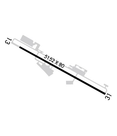
| Lat: N 3125.9 Long: W 08537.2 Elev: 358 Var: +04 Longest Runway: 5152 | ||
| CTAF: 122.7 | ||
| ||||||||||||||||||||||||||||||||||||||||||||
| ||||||||||||||||||||||||||||||||||||||||||||
| Rwy | Rwy | |||||||
| 5152x80 | 5152' | 5152x80 | 5152' | |||||
| Runway ID | Single Wheel | Double Wheel | Double Tandem Wheel | Dual Double Wheel |
| 13/31 | N/A | 25,000 | N/A | N/A |
| These numbers are Advisory and are not limits. The Airport Manager should have more accurate Weight Limits | ||||
 Airport Diagram might not be current. | |
| Facility Name: | OZARK/BLACKWELL FLD |
| City Name: | OZARK |
| County: | DALE |
| State abbrev: | AL |
| State Name: | ALABAMA |
| Ownership: | PUBLICLY OWNED |
| Use: | OPEN TO THE PUBLIC |
| Owner's Name: | TOWN OF OZARK |
| Address: | P.O. BOX 1987 |
| OZARK, AL 36361 | |
| Owner's Phone: | 334-774-5393 |
| Manager's Name: | DENISE ELLIS |
| Address: | 3269 HWY 231 S |
| OZARK, AL 36360 | |
| Phone: | 334-445-5045 |
| FAA Region: | SOUTHERN |
| FAA Field Office: | JAN |
| Date | Sunrise | Sunset |
|---|---|---|
| 06/07/26 Sunday | 5:37 | 19:45 |
| 06/08/26 Monday | 5:37 | 19:46 |
| 06/09/26 Tuesday | 5:37 | 19:46 |
| 06/10/26 Wednesday | 5:37 | 19:47 |
| 06/11/26 Thursday | 5:37 | 19:47 |
| 06/12/26 Friday | 5:37 | 19:47 |
| 06/13/26 Saturday | 5:37 | 19:48 |
| 06/14/26 Sunday | 5:37 | 19:48 |
| 06/15/26 Monday | 5:37 | 19:49 |
| 06/16/26 Tuesday | 5:37 | 19:49 |
| 06/17/26 Wednesday | 5:38 | 19:49 |
| 06/18/26 Thursday | 5:38 | 19:49 |
| 06/19/26 Friday | 5:38 | 19:50 |
| 06/20/26 Saturday | 5:38 | 19:50 |
| Airport Attendance Schedule | MON-FRI 0800-1700; AFT HRS SVC CALL 334-432-0039. |
| Airport Status | OPERATIONAL (This Status can change at any time - please check NOTAMS) |
| Airport Lighting Schedule | ACTVT REIL RWY 13 & 31; PAPI RWY 13 & 31; MIRL RWY 13/31 - CTAF. |
| Airport Storage Available | Tie Downs |
| Extra Services Available | Charter, Flight Instruction, Aircraft Rental |
| Wind Indicator | YES - (lighted) |
| Control Tower | NO |
| CTAF Frequency | 122.700 |
| Unicom Frequency | 122.700 |
| Rotating Beacon Color | WG |
| Segmented Circle | YES |
| Landing Fee | NO |
| Airport Inspected | STATE - performed by STATE AERONAUTICAL PERSONNEL |
| Inspection Date | 01/31/2025 |
| Type of Fuel Available | Grade 100LL, JET A (freeze point -40C); -10AVGAS 24 HR CREDIT CARD SVC AVBL. |
| Airframe Repair Service | MAJOR |
| Power Plant Repair Service | MAJOR |
| Latitude | N3125.9 |
| Longitude | W08537.2 (ESTIMATED) |
| Arpt Elevation | 357ft (SURVEYED) |
| Magnetic Variation | 04W |
| 2 miles SE | of OZARK |
| Traffic Pattern Altitude | |
| Sectional Chart | NEW ORLEANS |
| Operations (Reported) | Yearly | Avg. Daily |
|---|---|---|
| General Aviation Transient | 0 | 0 |
| General Aviation Local | 0 | 0 |
| Air Taxi | 0 | 0 |
| Commerical | 0 | 0 |
| Commuter | 0 | 0 |
| Military | 0 | 0 |
| Aircraft based on Field | |
|---|---|
| General Aviation Singles | 0 |
| General Aviation Multi | 0 |
| Jet Aircraft | 0 |
| General Aviation Helicopters | 0 |
| Military Aircraft | 0 |
| Gliders | 0 |
| Ultralights | 0 |
| FSS on field | NO |
| FSS tie-in | ANNISTON |
| FSS Phone | 1-800-WX-BRIEF |
| Who issues Notams | ANB |
| Notam D service at airport | YES |
| ARTCC Name | JACKSONVILLE |
| Airport Certification | |
| Aircraft Rescue & Firefighting Index | None |
| Airport of Entry | No |
| Custom Landing Rights | No |
| Joint Civil/Military | No |
| Military Landing rights | YES |
| NATIONAL PLAN OF INTEGRATED AIRPORT SYSTEMS (NPIAS) |
| GRANT AGREEMENTS UNDER FAAP/ADAP/AIP |
| ASSURANCES PURSUANT TO TITLE VI, CIVIL RIGHTS ACT OF 1964 |
| LOW FLYING HOP IN TFC PAT. |
| RWY & PARL TWYS CNTRLN SEPN IS 240 FT. |
| PILOTS DEPG BLACKWELL VFR TO THE EAST OR NORTH RMN AT 1500 FT MSL OR BLW TIL APRXLY 5 MI FM THE ARPT TO AVOID CONFLICT WITH TFC ON IFR APCH TO THE DOTHAN ARPT. |
| FOR CD CTC CAIRNS APCH AT 334-255-8402, WHEN APCH CLSD CTC JACKSONVILLE ARTCC AT 904-845-1592. |
| RWY 13/31 CLSD TO HEL RUNNING LDG BY SKID EQUIPPED HEL |
Airport Communications & Frequencies:
| |||||||||||||||||
| Runway: 13 | Runway: 31 | ||
| Mag heading: | 125° | Mag heading: | 305° |
| Rwy Slope: | -.33% Down | Rwy Slope: | .33% Up |
| Approach: | Approach: | ||
| Pattern: | Left Traffic | Pattern: | Left Traffic |
| Markings: | NONPRECISION INSTRUMENT | Markings: | NONPRECISION INSTRUMENT |
| Marking Condition: | FAIR | Marking Condition: | FAIR |
| Arresting Dev: | Arresting Dev: | ||
| Lat & Long: | N3126.1 W08537.7 | Lat. & Long.: | N3125.7 W08536.8 |
| Elev: | 357.9 ft. MSL | Elev: | 340.8 ft. MSL |
| TCH: | 36 ft. AGL | TCH: | 40 ft. AGL |
| Visual Glide Path: | 3.60 degrees | Visual Glide Path: | 3.00 degrees |
| Displaced Threshold: | No | Displaced Threshold: | No |
| Touchdown Zone: | YES | Touchdown Zone: | YES |
| Touchdown Elev.: | 357.9 feet | Touchdown Elev.: | 349.9 feet |
| Visual Glide Slope: | 4-Light PAPI on RIGHT side of Runway | Visual Glide Slope: | 4-Light PAPI on LEFT side of Runway |
| RVR Equipment: | RVR Equipment: | ||
| RVV Equipment: | NO | RVV Equipment: | NO |
| Approach Lights: | Approach Lights: | ||
| REIL: | YES | REIL: | YES |
| Centerline Lights: | NO | Centerline Lights: | NO |
| Touchdown lights: | NO | Touchdown lights: | NO |
| Runway Category: | Runway with a Non-precision Approach having visibility minimums greater than 3/4 mile | Runway Category: | Runway with a Non-precision Approach having visibility minimums greater than 3/4 mile |
| Declared Distances: | Declared Distances: | ||
| Obstructions: | TREE | Obstructions: | TREE |
| Marked: | NOT Marked/Lighted | Marked: | NOT Marked/Lighted |
| Clearance slope: | 9:1; CTLG OBSTN EXCEEDS A 45 DEG SLP. | Clearance slope: | 2:1 |
| Obstruction height: | 45 feet AGL | Obstruction height: | 19 feet AGL |
| Dist. from runway: | 615 feet | Dist. from runway: | 247 feet |
| Centerline offset: | 615 left of centerline | Centerline offset: | 163 feet right of centerline |
| Comments: | Comments: |
Thanks for using FltPlan.com
all rights reserved © 1999-2026 by Flight Plan LLC
