
| SPRING HILL STERLING PA |
| |
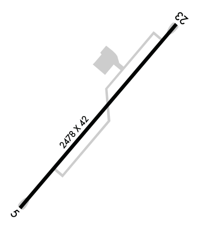
| Lat: N 4120.8 Long: W 07525.0 Elev: 1729 Var: +12 Longest Runway: 2478 | ||
| CTAF: 122.9 | ||
| ||||||
|
| Rwy | Rwy | |||||||
| 2478x42 | 2078' | 2478x42 | 2478' | |||||
| Runway ID | Single Wheel | Double Wheel | Double Tandem Wheel | Dual Double Wheel |
| 05/23 | 10,000 | N/A | N/A | N/A |
| These numbers are Advisory and are not limits. The Airport Manager should have more accurate Weight Limits | ||||
 Airport Diagram might not be current. | |
| Facility Name: | SPRING HILL |
| City Name: | STERLING |
| County: | WAYNE |
| State abbrev: | PA |
| State Name: | PENNSYLVANIA |
| Ownership: | PRIVATELY OWNED |
| Use: | OPEN TO THE PUBLIC |
| Owner's Name: | 366 SPRING HILL ROAD LLC |
| Address: | 2413 HUBBARD STREET |
| BROOKLYN, NY 11235 | |
| Owner's Phone: | 646-220-8333 |
| Manager's Name: | WAYNE SAAR |
| Address: | PO BOX 67 |
| STERLING, PA 18463 | |
| Phone: | 570-689-9316 |
| FAA Region: | EASTERN |
| FAA Field Office: | HAR |
| Date | Sunrise | Sunset |
|---|---|---|
| 09/24/21 Friday | 6:51 | 18:56 |
| 09/25/21 Saturday | 6:52 | 18:54 |
| 09/26/21 Sunday | 6:53 | 18:52 |
| 09/27/21 Monday | 6:54 | 18:51 |
| 09/28/21 Tuesday | 6:55 | 18:49 |
| 09/29/21 Wednesday | 6:56 | 18:47 |
| 09/30/21 Thursday | 6:57 | 18:46 |
| 10/01/21 Friday | 6:58 | 18:44 |
| 10/02/21 Saturday | 6:59 | 18:42 |
| 10/03/21 Sunday | 7:00 | 18:41 |
| 10/04/21 Monday | 7:01 | 18:39 |
| 10/05/21 Tuesday | 7:02 | 18:37 |
| 10/06/21 Wednesday | 7:03 | 18:36 |
| 10/07/21 Thursday | 7:04 | 18:34 |
| Airport Attendance Schedule | MON-FRI 0800-1700; FOR SVC AFT HRS CALL 570-242-5771. |
| Airport Status | OPERATIONAL (This Status can change at any time - please check NOTAMS) |
| Airport Lighting Schedule | ACTVT LIRL RY 05/23 - CTAF 122.9.; ACTVT ARPT BCN - CTAF 122.9. |
| Airport Storage Available | Tie Downs |
| Extra Services Available | NONE |
| Wind Indicator | YES - (lighted) |
| Control Tower | NO |
| CTAF Frequency | 122.900 |
| Unicom Frequency | |
| Rotating Beacon Color | CLEAR-GREEN (Light Land Airport) |
| Segmented Circle | NO |
| Landing Fee | NO |
| Airport Inspected | STATE - performed by STATE AERONAUTICAL PERSONNEL |
| Inspection Date | 12/01/2020 |
| Type of Fuel Available | Grade 100LL |
| Airframe Repair Service | None |
| Power Plant Repair Service | None |
| Latitude | N4120.8 |
| Longitude | W07525.0 (ESTIMATED) |
| Arpt Elevation | 1728ft (SURVEYED) |
| Magnetic Variation | 12W |
| 1 miles NW | of STERLING |
| Traffic Pattern Altitude | |
| Sectional Chart | NEW YORK |
| Operations (Reported) | Yearly | Avg. Daily |
|---|---|---|
| General Aviation Transient | 1000 | 3 |
| General Aviation Local | 1000 | 3 |
| Air Taxi | 0 | 0 |
| Commerical | 0 | 0 |
| Commuter | 0 | 0 |
| Military | 10 | 0 |
| Aircraft based on Field | |
|---|---|
| General Aviation Singles | 1 |
| General Aviation Multi | 0 |
| Jet Aircraft | 0 |
| General Aviation Helicopters | 0 |
| Military Aircraft | 0 |
| Gliders | 0 |
| Ultralights | 0 |
| FSS on field | NO |
| FSS tie-in | WILLIAMSPORT |
| FSS Phone | 1-800-WX-BRIEF |
| Who issues Notams | IPT |
| Notam D service at airport | YES |
| ARTCC Name | NEW YORK |
| Airport Certification | |
| Aircraft Rescue & Firefighting Index | None |
| Airport of Entry | No |
| Custom Landing Rights | No |
| Joint Civil/Military | No |
| Military Landing rights | No |
| WINTER MONTHS CALL FOR RWY CONDS. |
| RWY 05 CLSD LDG SS-SR. |
| DEER ON & INVOF ARPT. |
| FOR CD CTC WILKES-BARRE APCH AT 570-655-2084. |
Airport Communications & Frequencies:
| ||||||||||||
| Runway: 05 | Runway: 23 | ||
| Mag heading: | 51° | Mag heading: | 231° |
| Rwy Slope: | -2.43% Down | Rwy Slope: | 2.43% Up |
| Approach: | Approach: | ||
| Pattern: | Left Traffic | Pattern: | Left Traffic |
| Markings: | BASIC | Markings: | BASIC |
| Marking Condition: | GOOD | Marking Condition: | GOOD |
| Arresting Dev: | Arresting Dev: | ||
| Lat & Long: | N4120.7 W07525.1 | Lat. & Long.: | N4121.0 W07524.8 |
| Elev: | 1728.9 ft. MSL | Elev: | 1668.6 ft. MSL |
| TCH: | TCH: | ||
| Visual Glide Path: | Visual Glide Path: | ||
| Displaced Threshold: | 400 feet | Displaced Threshold: | No |
| Touchdown Zone: | YES | Touchdown Zone: | YES |
| Touchdown Elev.: | 1728.9 feet | Touchdown Elev.: | 1728.9 feet |
| Visual Glide Slope: | Visual Glide Slope: | ||
| RVR Equipment: | RVR Equipment: | ||
| RVV Equipment: | NO | RVV Equipment: | NO |
| Approach Lights: | Approach Lights: | ||
| REIL: | NO | REIL: | NO |
| Centerline Lights: | NO | Centerline Lights: | NO |
| Touchdown lights: | NO | Touchdown lights: | NO |
| Runway Category: | Runway with a Visual Approach | Runway Category: | Runway with a Visual Approach |
| Declared Distances: | Declared Distances: | ||
| Obstructions: | HILL | Obstructions: | |
| Marked: | LIGHTED | Marked: | |
| Clearance slope: | APCH RATIO 21:1 TO DSPLCD THLD | Clearance slope: | 20:1 |
| Obstruction height: | 29 feet AGL | Obstruction height: | |
| Dist. from runway: | 201 feet | Dist. from runway: | |
| Centerline offset: | Centerline offset: | ||
| Comments: | RWY 05 +29 FT HILL 185-200 FT FM THLD; 0B. | Comments: |
Thanks for using FltPlan.com
all rights reserved © 1999-2021 by Flight Plan LLC
