
| CAIRO-GRADY COUNTY CAIRO GA |
| |
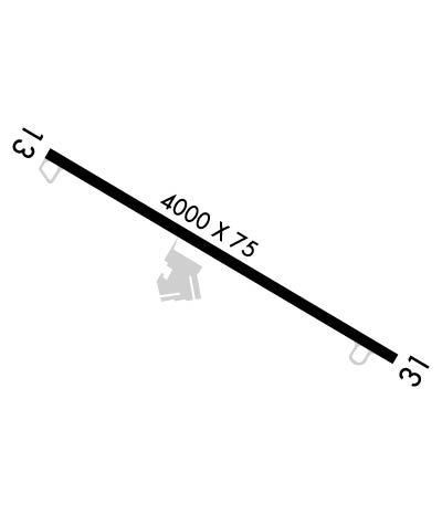
| Lat: N 3053.3 Long: W 08409.3 Elev: 264 Var: +04 Longest Runway: 4000 | ||
| CTAF: 122.7 | ||
| ||||||||||||||||||||||||||||||||||||||||||||
| ||||||||||||||||||||||||||||||||||||||||||||
| Rwy | Rwy | |||||||
| 4000x75 | 4000' | 4000x75 | 4000' | |||||
| Runway ID | Single Wheel | Double Wheel | Double Tandem Wheel | Dual Double Wheel |
| 13/31 | 12,000 | N/A | N/A | N/A |
| These numbers are Advisory and are not limits. The Airport Manager should have more accurate Weight Limits | ||||
 Airport Diagram might not be current. | |
| Facility Name: | CAIRO-GRADY COUNTY |
| City Name: | CAIRO |
| County: | GRADY |
| State abbrev: | GA |
| State Name: | GEORGIA |
| Ownership: | PUBLICLY OWNED |
| Use: | OPEN TO THE PUBLIC |
| Owner's Name: | CITY OF CAIRO |
| Address: | BOX 29 |
| CAIRO, GA 39828 | |
| Owner's Phone: | 229-377-1722 |
| Manager's Name: | BOOKER GAINOR, CITY MGR |
| Address: | PO BOX 29, 259 EDNA LANE |
| CAIRO, GA 39828 | |
| Phone: | 229-327-1114 |
| FAA Region: | SOUTHERN |
| FAA Field Office: | ATL |
| Date | Sunrise | Sunset |
|---|---|---|
| 06/08/26 Monday | 6:33 | 20:39 |
| 06/09/26 Tuesday | 6:33 | 20:39 |
| 06/10/26 Wednesday | 6:33 | 20:39 |
| 06/11/26 Thursday | 6:33 | 20:40 |
| 06/12/26 Friday | 6:33 | 20:40 |
| 06/13/26 Saturday | 6:33 | 20:41 |
| 06/14/26 Sunday | 6:33 | 20:41 |
| 06/15/26 Monday | 6:33 | 20:41 |
| 06/16/26 Tuesday | 6:33 | 20:42 |
| 06/17/26 Wednesday | 6:33 | 20:42 |
| 06/18/26 Thursday | 6:33 | 20:42 |
| 06/19/26 Friday | 6:33 | 20:42 |
| 06/20/26 Saturday | 6:34 | 20:43 |
| 06/21/26 Sunday | 6:34 | 20:43 |
| Airport Attendance Schedule | MON-FRI 0900-1600 |
| Airport Status | OPERATIONAL (This Status can change at any time - please check NOTAMS) |
| Airport Lighting Schedule | MIRL RY 13/31 AND PAPI RYS 13 & 31 OPER CONT DUSK-0000; AFTER 0000 ACTVT - CTAF. |
| Airport Storage Available | Tie Downs |
| Extra Services Available | Crop Dusting |
| Wind Indicator | YES - (lighted) |
| Control Tower | NO |
| CTAF Frequency | 122.700 |
| Unicom Frequency | 122.700 |
| Rotating Beacon Color | WG |
| Segmented Circle | YES |
| Landing Fee | NO |
| Airport Inspected | STATE - performed by STATE AERONAUTICAL PERSONNEL |
| Inspection Date | 02/05/2026 |
| Type of Fuel Available | Grade 100LL; -10FUEL AVAILABLE DURING ATTENDED HOURS |
| Airframe Repair Service | MAJOR |
| Power Plant Repair Service | MAJOR |
| Latitude | N3053.3 |
| Longitude | W08409.3 (ESTIMATED) |
| Arpt Elevation | 263ft (SURVEYED) |
| Magnetic Variation | 04W |
| 3 miles E | of CAIRO |
| Traffic Pattern Altitude | |
| Sectional Chart | JACKSONVILLE |
| Operations (Reported) | Yearly | Avg. Daily |
|---|---|---|
| General Aviation Transient | 0 | 0 |
| General Aviation Local | 0 | 0 |
| Air Taxi | 0 | 0 |
| Commerical | 0 | 0 |
| Commuter | 0 | 0 |
| Military | 0 | 0 |
| Aircraft based on Field | |
|---|---|
| General Aviation Singles | 0 |
| General Aviation Multi | 0 |
| Jet Aircraft | 0 |
| General Aviation Helicopters | 0 |
| Military Aircraft | 0 |
| Gliders | 0 |
| Ultralights | 0 |
| FSS on field | NO |
| FSS tie-in | MACON |
| FSS Phone | 1-800-WX-BRIEF |
| Who issues Notams | MCN |
| Notam D service at airport | YES |
| ARTCC Name | JACKSONVILLE |
| Airport Certification | |
| Aircraft Rescue & Firefighting Index | None |
| Airport of Entry | No |
| Custom Landing Rights | No |
| Joint Civil/Military | No |
| Military Landing rights | YES |
| NATIONAL PLAN OF INTEGRATED AIRPORT SYSTEMS (NPIAS) |
| GRANT AGREEMENTS UNDER FAAP/ADAP/AIP |
| ASSURANCES PURSUANT TO TITLE VI, CIVIL RIGHTS ACT OF 1964 |
| FOR CD CTC TALLAHASSEE APCH AT 850-942-8311, WHEN APCH CLSD CTC JACKSONVILLE ARTCC AT 904-845-1592. |
Airport Communications & Frequencies:
| |||||||||||||||||
| Runway: 13 | Runway: 31 | ||
| Mag heading: | 125° | Mag heading: | 305° |
| Rwy Slope: | -.69% Down | Rwy Slope: | .69% Up |
| Approach: | Approach: | ||
| Pattern: | Left Traffic | Pattern: | Left Traffic |
| Markings: | NONPRECISION INSTRUMENT | Markings: | NONPRECISION INSTRUMENT |
| Marking Condition: | GOOD | Marking Condition: | GOOD |
| Arresting Dev: | Arresting Dev: | ||
| Lat & Long: | N3053.4 W08409.6 | Lat. & Long.: | N3053.1 W08409.0 |
| Elev: | 263.6 ft. MSL | Elev: | 236.2 ft. MSL |
| TCH: | 34 ft. AGL | TCH: | 27 ft. AGL |
| Visual Glide Path: | 3.50 degrees | Visual Glide Path: | 3.00 degrees |
| Displaced Threshold: | No | Displaced Threshold: | No |
| Touchdown Zone: | YES | Touchdown Zone: | YES |
| Touchdown Elev.: | 263.7 feet | Touchdown Elev.: | 260.5 feet |
| Visual Glide Slope: | 2-Light PAPI on LEFT side of Runway | Visual Glide Slope: | 2-Light PAPI on LEFT side of Runway |
| RVR Equipment: | RVR Equipment: | ||
| RVV Equipment: | NO | RVV Equipment: | NO |
| Approach Lights: | Approach Lights: | ||
| REIL: | NO | REIL: | NO |
| Centerline Lights: | NO | Centerline Lights: | NO |
| Touchdown lights: | NO | Touchdown lights: | NO |
| Runway Category: | Runway with a Non-precision Approach | Runway Category: | Runway with a Non-precision Approach |
| Declared Distances: | Declared Distances: | ||
| Obstructions: | TREES | Obstructions: | TREES |
| Marked: | NOT Marked/Lighted | Marked: | NOT Marked/Lighted |
| Clearance slope: | 16:1 | Clearance slope: | 5:1 |
| Obstruction height: | 20 feet AGL | Obstruction height: | 8 feet AGL |
| Dist. from runway: | 520 feet | Dist. from runway: | 240 feet |
| Centerline offset: | 125 right of centerline | Centerline offset: | 242 feet right of centerline |
| Comments: | Comments: |
Thanks for using FltPlan.com
all rights reserved © 1999-2026 by Flight Plan LLC
