
| LAUREL MUNI LAUREL MT |
| |
| Lat: N 4542.3 Long: W 10845.6 Elev: 3543 Var: -14 Longest Runway: 5199 | ||
| AWOS: 123.05 CTAF: 123.05 | ||
| ||||||||||||||||||||||||||||||||||||||||||||
| ||||||||||||||||||||||||||||||||||||||||||||
| ||||||||||||||||||||||||||||||||||||||||||||
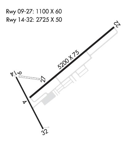
| Rwy | Rwy | |||||||
| 5199x75 | 5199' | 5199x75 | 5199' | |||||
| 1100x60 | 1100' | 1100x60 | 1100' | |||||
| 3002x60 | 3002' | 3002x60 | 3002' | |||||
| Runway ID | Single Wheel | Double Wheel | Double Tandem Wheel | Dual Double Wheel |
| 04/22 | 12,500 | N/A | N/A | N/A |
| 09/27 | N/A | N/A | N/A | N/A |
| 14/32 | 12,500 | N/A | N/A | N/A |
| These numbers are Advisory and are not limits. The Airport Manager should have more accurate Weight Limits | ||||
 Airport Diagram might not be current. | |
| Facility Name: | LAUREL MUNI |
| City Name: | LAUREL |
| County: | YELLOWSTONE |
| State abbrev: | MT |
| State Name: | MONTANA |
| Ownership: | PUBLICLY OWNED |
| Use: | OPEN TO THE PUBLIC |
| Owner's Name: | AIRPORT AUTHORITY |
| Address: | BOX 242 |
| LAUREL, MT 59044 | |
| Owner's Phone: | 406-628-0172 |
| Manager's Name: | AIRPORT BOARD |
| Address: | PO BOX 242 |
| LAUREL, MT 59044 | |
| Phone: | 406-628-0172 |
| FAA Region: | NORTHWEST MOUNTAIN |
| FAA Field Office: | HLN |
| Date | Sunrise | Sunset |
|---|---|---|
| 06/08/26 Monday | 5:26 | 21:02 |
| 06/09/26 Tuesday | 5:26 | 21:03 |
| 06/10/26 Wednesday | 5:25 | 21:04 |
| 06/11/26 Thursday | 5:25 | 21:04 |
| 06/12/26 Friday | 5:25 | 21:05 |
| 06/13/26 Saturday | 5:25 | 21:05 |
| 06/14/26 Sunday | 5:25 | 21:06 |
| 06/15/26 Monday | 5:25 | 21:06 |
| 06/16/26 Tuesday | 5:25 | 21:07 |
| 06/17/26 Wednesday | 5:25 | 21:07 |
| 06/18/26 Thursday | 5:25 | 21:07 |
| 06/19/26 Friday | 5:25 | 21:08 |
| 06/20/26 Saturday | 5:25 | 21:08 |
| 06/21/26 Sunday | 5:25 | 21:08 |
| Airport Attendance Schedule | MON-FRI 0800-1700, SAT-SUN INTERMITTANT |
| Airport Status | OPERATIONAL (This Status can change at any time - please check NOTAMS) |
| Airport Lighting Schedule | ACTVT PAPI RWY 04 & 22 & 14 & 32; MIRL RWY 04/22 & 14/32 - CTAF. |
| Airport Storage Available | Tie Downs, Hanger |
| Extra Services Available | Charter, Flight Instruction, Aircraft Sales |
| Wind Indicator | YES - (lighted) |
| Control Tower | NO |
| CTAF Frequency | 123.050 |
| Unicom Frequency | 123.050; AUTOMATED UNICOM |
| Rotating Beacon Color | WG |
| Segmented Circle | YES |
| Landing Fee | NO |
| Airport Inspected | STATE - performed by STATE AERONAUTICAL PERSONNEL |
| Inspection Date | 03/26/2025 |
| Type of Fuel Available | Grade 100LL, JET A (freeze point -40C) |
| Airframe Repair Service | MINOR |
| Power Plant Repair Service | MINOR |
| Latitude | N4542.3 |
| Longitude | W10845.6 (ESTIMATED) |
| Arpt Elevation | 3542ft (SURVEYED) |
| Magnetic Variation | 14E |
| 2 miles N | of LAUREL |
| Traffic Pattern Altitude | |
| Sectional Chart | BILLINGS |
| Operations (Reported) | Yearly | Avg. Daily |
|---|---|---|
| General Aviation Transient | 0 | 0 |
| General Aviation Local | 0 | 0 |
| Air Taxi | 0 | 0 |
| Commerical | 0 | 0 |
| Commuter | 0 | 0 |
| Military | 0 | 0 |
| Aircraft based on Field | |
|---|---|
| General Aviation Singles | 0 |
| General Aviation Multi | 0 |
| Jet Aircraft | 0 |
| General Aviation Helicopters | 0 |
| Military Aircraft | 0 |
| Gliders | 0 |
| Ultralights | 0 |
| FSS on field | NO |
| FSS tie-in | GREAT FALLS |
| FSS Phone | 1-800-WX-BRIEF |
| Who issues Notams | GTF |
| Notam D service at airport | YES |
| ARTCC Name | SALT LAKE CITY |
| Airport Certification | |
| Aircraft Rescue & Firefighting Index | None |
| Airport of Entry | No |
| Custom Landing Rights | No |
| Joint Civil/Military | No |
| Military Landing rights | YES |
| NATIONAL PLAN OF INTEGRATED AIRPORT SYSTEMS (NPIAS) |
| GRANT AGREEMENTS UNDER FAAP/ADAP/AIP |
| ASSURANCES PURSUANT TO TITLE VI, CIVIL RIGHTS ACT OF 1964 |
| FOR CD CTC BILLINGS APCH AT 406-255-2798 |
| NUMEROUS DEER AND ANTELOPE ON AND INVOF OF RY. |
| RY 09/27 NOT MAINTAINED DURG WINTER. |
| INTMT SNOW REMOVAL- BE ALERT DURING WINTER MONTHS. |
Airport Communications & Frequencies:
| ||||||||||||||||||
| Runway: 04 | Runway: 22 | ||
| Mag heading: | 36° | Mag heading: | 216° |
| Rwy Slope: | -.64% Down | Rwy Slope: | .64% Up |
| Approach: | Approach: | ||
| Pattern: | Left Traffic | Pattern: | Left Traffic |
| Markings: | NONPRECISION INSTRUMENT | Markings: | NONPRECISION INSTRUMENT |
| Marking Condition: | FAIR | Marking Condition: | FAIR |
| Arresting Dev: | Arresting Dev: | ||
| Lat & Long: | N4542.1 W10845.8 | Lat. & Long.: | N4542.6 W10844.9 |
| Elev: | 3487.8 ft. MSL | Elev: | 3454.4 ft. MSL |
| TCH: | 34 ft. AGL | TCH: | 41 ft. AGL |
| Visual Glide Path: | 3.00 degrees | Visual Glide Path: | 3.00 degrees |
| Displaced Threshold: | No | Displaced Threshold: | No |
| Touchdown Zone: | YES | Touchdown Zone: | YES |
| Touchdown Elev.: | 3487.8 feet | Touchdown Elev.: | 3471.8 feet |
| Visual Glide Slope: | 2-Light PAPI on LEFT side of Runway | Visual Glide Slope: | 2-Light PAPI on LEFT side of Runway |
| RVR Equipment: | RVR Equipment: | ||
| RVV Equipment: | NO | RVV Equipment: | NO |
| Approach Lights: | Approach Lights: | ||
| REIL: | NO | REIL: | NO |
| Centerline Lights: | NO | Centerline Lights: | NO |
| Touchdown lights: | NO | Touchdown lights: | NO |
| Runway Category: | Runway with a Non-precision Approach | Runway Category: | Runway with a Non-precision Approach |
| Declared Distances: | Declared Distances: |
| Runway: 09 | Runway: 27 | ||
| Mag heading: | 84° | Mag heading: | 264° |
| Rwy Slope: | -2.41% Down | Rwy Slope: | 2.41% Up |
| Approach: | Approach: | ||
| Pattern: | Left Traffic | Pattern: | Left Traffic |
| Markings: | Markings: | ||
| Marking Condition: | 09/27 MARKER CONES FULL RY LENGTH. | Marking Condition: | |
| Arresting Dev: | Arresting Dev: | ||
| Lat & Long: | N4542.3 W10846.0 | Lat. & Long.: | N4542.2 W10845.8 |
| Elev: | 3511.0 ft. MSL | Elev: | 3484.5 ft. MSL |
| TCH: | TCH: | ||
| Visual Glide Path: | Visual Glide Path: | ||
| Displaced Threshold: | No | Displaced Threshold: | No |
| Touchdown Zone: | YES | Touchdown Zone: | YES |
| Touchdown Elev.: | 3511.0 feet | Touchdown Elev.: | 3484.5 feet |
| Visual Glide Slope: | Visual Glide Slope: | ||
| RVR Equipment: | RVR Equipment: | ||
| RVV Equipment: | NO | RVV Equipment: | NO |
| Approach Lights: | Approach Lights: | ||
| REIL: | NO | REIL: | NO |
| Centerline Lights: | NO | Centerline Lights: | NO |
| Touchdown lights: | NO | Touchdown lights: | NO |
| Runway Category: | Runway with a Visual Approach | Runway Category: | Runway with a Visual Approach |
| Declared Distances: | Declared Distances: |
| Runway: 14 | Runway: 32 | ||
| Mag heading: | 138° | Mag heading: | 318° |
| Rwy Slope: | -2.00% Down | Rwy Slope: | 2.00% Up |
| Approach: | Approach: | ||
| Pattern: | Left Traffic | Pattern: | Left Traffic |
| Markings: | BASIC | Markings: | BASIC |
| Marking Condition: | GOOD | Marking Condition: | GOOD |
| Arresting Dev: | Arresting Dev: | ||
| Lat & Long: | N4542.4 W10846.2 | Lat. & Long.: | N4542.0 W10845.9 |
| Elev: | 3542.6 ft. MSL | Elev: | 3482.6 ft. MSL |
| TCH: | 21 ft. AGL | TCH: | 21 ft. AGL |
| Visual Glide Path: | 4.00 degrees | Visual Glide Path: | 3.00 degrees |
| Displaced Threshold: | No | Displaced Threshold: | No |
| Touchdown Zone: | YES | Touchdown Zone: | YES |
| Touchdown Elev.: | 3542.6 feet | Touchdown Elev.: | 3542.6 feet |
| Visual Glide Slope: | 2-Light PAPI on LEFT side of Runway | Visual Glide Slope: | 2-Light PAPI on LEFT side of Runway |
| RVR Equipment: | RVR Equipment: | ||
| RVV Equipment: | NO | RVV Equipment: | NO |
| Approach Lights: | Approach Lights: | ||
| REIL: | NO | REIL: | NO |
| Centerline Lights: | NO | Centerline Lights: | NO |
| Touchdown lights: | NO | Touchdown lights: | NO |
| Runway Category: | Runway with a Visual Approach | Runway Category: | Runway with a Visual Approach |
| Declared Distances: | Declared Distances: |
Thanks for using FltPlan.com
all rights reserved © 1999-2026 by Flight Plan LLC
