
| NEW YORK SKYPORTS (SPB) NEW YORK NY |
| |
| Lat: N 4044.0 Long: W 07358.4 Elev: 0 Var: +13 Longest Runway: 10000 | ||
| CTAF: 122.9 | ||
| ||||||||||||||||||||||||||||||||
| ||||||||||||||||||||||||||||||||
| ||||||||||||||||||||||||||||||||
| Rwy | Rwy | |||||||
| 10000x1000 | 10000' | 10000x1000 | 10000' | |||||
| Runway ID | Single Wheel | Double Wheel | Double Tandem Wheel | Dual Double Wheel |
| N/S | N/A | N/A | N/A | N/A |
| These numbers are Advisory and are not limits. The Airport Manager should have more accurate Weight Limits | ||||
| FltPlan does not have IFR approach charts available for K6N7. |
| Facility Name: | NEW YORK SKYPORTS INC |
| City Name: | NEW YORK |
| County: | NEW YORK |
| State abbrev: | NY |
| State Name: | NEW YORK |
| Ownership: | PUBLICLY OWNED |
| Use: | OPEN TO THE PUBLIC |
| Owner's Name: | NEW YORK CITY - ECONOMIC DEV CORP |
| Address: | 2430 FDR DRIVE - EAST SERVICE RD |
| NEW YORK, NY 10010 | |
| Owner's Phone: | (212) 481-4806 |
| Manager's Name: | TORRELL MILLER |
| Address: | 2430 FDR DRIVE - EAST SERVICE RD |
| NEW YORK, NY 10010 | |
| Phone: | (201) 214-0969 |
| FAA Region: | EASTERN |
| FAA Field Office: | NYC |
| Date | Sunrise | Sunset |
|---|---|---|
| 06/08/26 Monday | 5:25 | 20:25 |
| 06/09/26 Tuesday | 5:24 | 20:26 |
| 06/10/26 Wednesday | 5:24 | 20:26 |
| 06/11/26 Thursday | 5:24 | 20:27 |
| 06/12/26 Friday | 5:24 | 20:27 |
| 06/13/26 Saturday | 5:24 | 20:28 |
| 06/14/26 Sunday | 5:24 | 20:28 |
| 06/15/26 Monday | 5:24 | 20:29 |
| 06/16/26 Tuesday | 5:24 | 20:29 |
| 06/17/26 Wednesday | 5:24 | 20:29 |
| 06/18/26 Thursday | 5:24 | 20:30 |
| 06/19/26 Friday | 5:24 | 20:30 |
| 06/20/26 Saturday | 5:24 | 20:30 |
| 06/21/26 Sunday | 5:25 | 20:31 |
| Airport Attendance Schedule | 7 Days A Week 0800-DUSK |
| Airport Status | OPERATIONAL (This Status can change at any time - please check NOTAMS) |
| Airport Lighting Schedule | |
| Airport Storage Available | NONE |
| Extra Services Available | NONE |
| Wind Indicator | YES - (unlit) |
| Control Tower | NO |
| CTAF Frequency | 122.900 |
| Unicom Frequency | |
| Rotating Beacon Color | |
| Segmented Circle | NO |
| Landing Fee | YES |
| Airport Inspected | STATE - performed by STATE AERONAUTICAL PERSONNEL |
| Inspection Date | 06/23/2025 |
| Type of Fuel Available | None |
| Airframe Repair Service | None |
| Power Plant Repair Service | None |
| Latitude | N4044.0 |
| Longitude | W07358.4 (ESTIMATED) |
| Arpt Elevation | 0ft (ESTIMATED) |
| Magnetic Variation | 13W |
| 0 miles E | of NEW YORK |
| Traffic Pattern Altitude | |
| Sectional Chart | NEW YORK |
| Operations (Reported) | Yearly | Avg. Daily |
|---|---|---|
| General Aviation Transient | 0 | 0 |
| General Aviation Local | 0 | 0 |
| Air Taxi | 0 | 0 |
| Commerical | 0 | 0 |
| Commuter | 0 | 0 |
| Military | 0 | 0 |
| Aircraft based on Field | |
|---|---|
| General Aviation Singles | 0 |
| General Aviation Multi | 0 |
| Jet Aircraft | 0 |
| General Aviation Helicopters | 0 |
| Military Aircraft | 0 |
| Gliders | 0 |
| Ultralights | 0 |
| FSS on field | NO |
| FSS tie-in | NEW YORK |
| FSS Phone | 1-800-WX-BRIEF |
| Who issues Notams | ISP |
| Notam D service at airport | YES |
| ARTCC Name | NEW YORK |
| Airport Certification | |
| Aircraft Rescue & Firefighting Index | None |
| Airport of Entry | No |
| Custom Landing Rights | No |
| Joint Civil/Military | No |
| Military Landing rights | No |
| NATIONAL PLAN OF INTEGRATED AIRPORT SYSTEMS (NPIAS) |
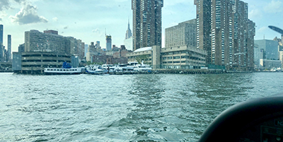
| E RIVER-VELOCITY 2.6MPH IN SSW DRCTN. HVY BOAT TFC IN RIVER. |
| PILOTS REQUIRED TO TAXI 1000' OFF-SHORE ON MANHATAN SIDE BEFORE BEGINNING TAKEOFF. |
| PILOTS REQUIRED NOT TO FLY OVER THE 59TH STREET BRIDGE. |
| 3 BLADED PROPS REQ'D ON ALL SEAPLANES. |
| PILOTS MUST COMPLETE A PROVING FLIGHT W/AN AUTHORIZED MEMBER OF THE N.E. SEAPLANES PILOT'S ASSOC. PRIOR TO SPB USE |
| NO TIE-DOWNS AND NO OVERNIGHT STAYS AVBL. |
| FOR CD CTC NEW YORK APCH AT 800-645-3206. |
| CH13 (VHF 165.65) IS MONITORED AT SEAPORT FOR INBD BOAT TFC AND INTERSHIP NAV SAFETY. |
| Runway: N | Runway: S | ||
| Mag heading: | N/A | Mag heading: | N/A |
| Approach: | Approach: | ||
| Pattern: | Left Traffic | Pattern: | Left Traffic |
| Markings: | Markings: | ||
| Marking Condition: | Marking Condition: | ||
| Arresting Dev: | Arresting Dev: | ||
| Lat & Long: | Lat. & Long.: | ||
| Elev: | N/A | Elev: | N/A |
| TCH: | TCH: | ||
| Visual Glide Path: | Visual Glide Path: | ||
| Displaced Threshold: | No | Displaced Threshold: | No |
| Touchdown Zone: | NO | Touchdown Zone: | NO |
| Touchdown Elev.: | Touchdown Elev.: | ||
| Visual Glide Slope: | Visual Glide Slope: | ||
| RVR Equipment: | RVR Equipment: | ||
| RVV Equipment: | NO | RVV Equipment: | NO |
| Approach Lights: | Approach Lights: | ||
| REIL: | NO | REIL: | NO |
| Centerline Lights: | NO | Centerline Lights: | NO |
| Touchdown lights: | NO | Touchdown lights: | NO |
| Runway Category: | Runway Category: | ||
| Declared Distances: | Declared Distances: |
Thanks for using FltPlan.com
all rights reserved © 1999-2026 by Flight Plan LLC