| SISTERS EAGLE AIR SISTERS OR |
| |
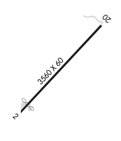
| Lat: N 4418.3 Long: W 12132.3 Elev: 3168 Var: -19 Longest Runway: 3560 | ||
| CTAF: 122.9 | ||
| |||||||||||||||||||||||||||||||||||||||||||||||||||||||||||||
| |||||||||||||||||||||||||||||||||||||||||||||||||||||||||||||
| Rwy | Rwy | |||||||
| 3560x60 | 3220' | 3560x60 | 3560' | |||||
| Runway ID | Single Wheel | Double Wheel | Double Tandem Wheel | Dual Double Wheel |
| 02/20 | 4,000 | N/A | N/A | N/A |
| These numbers are Advisory and are not limits. The Airport Manager should have more accurate Weight Limits | ||||
| FltPlan does not have IFR approach charts available for K6K5. |
 Airport Diagram might not be current. | |
| Facility Name: | SISTERS EAGLE AIR |
| City Name: | SISTERS |
| County: | DESCHUTES |
| State abbrev: | OR |
| State Name: | OREGON |
| Ownership: | PRIVATELY OWNED |
| Use: | OPEN TO THE PUBLIC |
| Owner's Name: | SISTERS EAGLE AIR, INC. |
| Address: | PO BOX 507 |
| SISTERS, OR 97759 | |
| Owner's Phone: | 541-549-6011 |
| Manager's Name: | DAVID CAMPBELL |
| Address: | 15820 BARCLAY DR |
| SISTERS, OR 97759 | |
| Phone: | (541) 719-0602 |
| FAA Region: | NORTHWEST MOUNTAIN |
| FAA Field Office: | SEA |

| Date | Sunrise | Sunset |
|---|---|---|
| 09/24/21 Friday | 6:55 | 19:00 |
| 09/25/21 Saturday | 6:57 | 18:58 |
| 09/26/21 Sunday | 6:58 | 18:56 |
| 09/27/21 Monday | 6:59 | 18:55 |
| 09/28/21 Tuesday | 7:00 | 18:53 |
| 09/29/21 Wednesday | 7:01 | 18:51 |
| 09/30/21 Thursday | 7:03 | 18:49 |
| 10/01/21 Friday | 7:04 | 18:47 |
| 10/02/21 Saturday | 7:05 | 18:45 |
| 10/03/21 Sunday | 7:06 | 18:43 |
| 10/04/21 Monday | 7:07 | 18:42 |
| 10/05/21 Tuesday | 7:09 | 18:40 |
| 10/06/21 Wednesday | 7:10 | 18:38 |
| 10/07/21 Thursday | 7:11 | 18:36 |
| Airport Attendance Schedule | UNATTENDED |
| Airport Status | OPERATIONAL (This Status can change at any time - please check NOTAMS) |
| Airport Lighting Schedule | |
| Airport Storage Available | Tie Downs |
| Extra Services Available | NONE |
| Wind Indicator | YES - (unlit) |
| Control Tower | NO |
| CTAF Frequency | 122.900 |
| Unicom Frequency | |
| Rotating Beacon Color | |
| Segmented Circle | NO |
| Landing Fee | NO |
| Airport Inspected | STATE - performed by STATE AERONAUTICAL PERSONNEL |
| Inspection Date | 08/26/2019 |
| Type of Fuel Available | Grade 100LL |
| Airframe Repair Service | NONE |
| Power Plant Repair Service | NONE |
| Latitude | N4418.3 |
| Longitude | W12132.3 (ESTIMATED) |
| Arpt Elevation | 3168ft (ESTIMATED) |
| Magnetic Variation | 19E |
| 1 miles N | of SISTERS |
| Traffic Pattern Altitude | |
| Sectional Chart | KLAMATH FALLS |
| Operations (Reported) | Yearly | Avg. Daily |
|---|---|---|
| General Aviation Transient | 900 | 2 |
| General Aviation Local | 400 | 1 |
| Air Taxi | 100 | 0 |
| Commerical | 0 | 0 |
| Commuter | 0 | 0 |
| Military | 0 | 0 |
| Aircraft based on Field | |
|---|---|
| General Aviation Singles | 15 |
| General Aviation Multi | 2 |
| Jet Aircraft | 0 |
| General Aviation Helicopters | 0 |
| Military Aircraft | 0 |
| Gliders | 0 |
| Ultralights | 0 |
| FSS on field | NO |
| FSS tie-in | MC MINNVILLE |
| FSS Phone | 1-800-WX-BRIEF |
| Who issues Notams | MMV |
| Notam D service at airport | YES |
| ARTCC Name | SEATTLE |
| Airport Certification | |
| Aircraft Rescue & Firefighting Index | None |
| Airport of Entry | No |
| Custom Landing Rights | No |
| Joint Civil/Military | No |
| Military Landing rights | No |
| RISING TERRAIN OFF DEP END OF RY 02. CHECK DENSITY ALT/ACFT PERFORMANCE PRIOR TO TKOF. AVOID OVERFLIGHTS OF HOMES TO NE. |
| DEER ON & INVOF ARPT. |
| FOR CD CTC SEATTLE ARTCC AT 253-351-3694. |
| Runway: 02 | Runway: 20 | ||
| Mag heading: | N/A | Mag heading: | N/A |
| Approach: | Approach: | ||
| Pattern: | Left Traffic | Pattern: | Left Traffic |
| Markings: | NONSTANDARD | Markings: | NONSTANDARD |
| Marking Condition: | GOOD; RWY HAS W & YELLOW SIDESTRIPES & MARKINGS. | Marking Condition: | GOOD |
| Arresting Dev: | Arresting Dev: | ||
| Lat & Long: | N4418.0 W12132.6 | Lat. & Long.: | N4418.5 W12132.1 |
| Elev: | N/A | Elev: | N/A |
| TCH: | TCH: | ||
| Visual Glide Path: | Visual Glide Path: | ||
| Displaced Threshold: | 340 feet | Displaced Threshold: | No |
| Touchdown Zone: | NO | Touchdown Zone: | NO |
| Touchdown Elev.: | Touchdown Elev.: | ||
| Visual Glide Slope: | Visual Glide Slope: | ||
| RVR Equipment: | RVR Equipment: | ||
| RVV Equipment: | NO | RVV Equipment: | NO |
| Approach Lights: | Approach Lights: | ||
| REIL: | NO | REIL: | NO |
| Centerline Lights: | NO | Centerline Lights: | NO |
| Touchdown lights: | NO | Touchdown lights: | NO |
| Runway Category: | Runway with a Visual Approach | Runway Category: | Runway with a Visual Approach |
| Declared Distances: | Declared Distances: | ||
| Obstructions: | TREE | Obstructions: | TREES |
| Marked: | NOT Marked/Lighted | Marked: | NOT Marked/Lighted |
| Clearance slope: | SLP IS 12:1 TO DTHR. | Clearance slope: | 4:1 |
| Obstruction height: | 16 feet AGL | Obstruction height: | 85 feet AGL |
| Dist. from runway: | 201 feet | Dist. from runway: | 560 feet |
| Centerline offset: | 125 right of centerline | Centerline offset: | 100 feet left of centerline |
| Comments: | RWY 02 +15 FT ROAD 200' FROM THRSHLD; 4' FENCE AT 1' FROM RWY END AND 100' L OF CNTRLN; 16' ROAD AT 1' FROM RWY END AND 125' L OF CNTRLN. | Comments: | 5' FENCE AT 201' FROM RUNWAY END AND 100'L OF CENTERLINE |
Thanks for using FltPlan.com
all rights reserved © 1999-2021 by Flight Plan LLC