NOTICE: Information listed below may not be current.Airport Ident: K6G0
| Airport Name: ATHELONE WILLIAMS MEM, MICHIGAN
Location: Davison
Latitude: N4301.7 Longitude: W08331.8
Field Elevation: 780' Variation: W7° as of 01/06
Time Zone: UTC-5(-4DT)
Daylight Savings: First Sunday in April at 0200 to last Sunday in October at 0200 local time (Exception Arizona and that portion of Indiana in the Eastern Time Zone)
Customs: N/A
|
|
| DISTANCE from: | KTEB to K6G0 = 441 nm
| KMIA to K6G0 = 1045 nm
| KORD to K6G0 = 204 nm
| KDAL to K6G0 = 876 nm
| KSEA to K6G0 = 1643 nm
| KLAX to K6G0 = 1713 nm
|
|
| AIRPORT TYPE: | | Active airports having permanent type surface runways with less than the minimum facilities. |
|
Rotating Beacon: NO
|
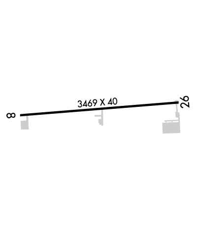
| RUNWAY INFORMATION: | Runway Ident: 26 /08
Runway Length: 3469
Runway Width: 40
Runway Surface: ASPHALT, ASPHALTIC CONCRETE, TAR MACADAM, OR BITUMEN BOUND MACADAM (INCLUDING ANY OF THESE SURFACE TYPES WITH CONCRETE ENDS).
Runway PCN Rating: -
Runway PCN Evaluation Method: N/A
Runway Open: YES
| Runway 26 Information
Runway True Heading: 265°
Runway Displaced Threshold: 36.8'
Takeoff Distance Available: 3469
Landing Distance Available: 3101
Runway Latitude: N4301.8
Runway Longitude: W08331.4
Runway Elevation: 780'
Runway Slope: -.1°
Runway TDZE: 780'
Runway Lighting: MIRL
| Runway 08 Information
Runway True Heading: 85°
Runway Displaced Threshold: 17
Takeoff Distance Available: 3469
Landing Distance Available: 3299
Runway Latitude: N4301.7
Runway Longitude: W08332.2
Runway Elevation: 776'
Runway Slope: .1°
Runway TDZE: 780
Runway Lighting: MIRL
|
|
|
COMMUNICATION INFORMATION
APPROACH/DEPARTURE CONTROL - FLINT APP/DEP (Opr 1045-0430Z, OT ctc CLEVELAND CENTER 126.75 348.75.-)
118.8 128.55 257.9
COMMON TRAFFIC ADVISORY FREQUENCY - CTAF
122.9
RADIO - LANSING RDO
122.3
|
COMMUNICATION REMARKS
RADIO - (FLINT RCO)
|
OPERATING HOURS
APPROACH/DEPARTURE CONTROL - Opr 1045-0430Z, OT ctc CLEVELAND CENTER 126.75 348.75.-
|
AIRPORT NAVAIDS
FNT - FLINT (VORTAC) - Bearing: 75° Distance: 10.3 nm
|