
| SKANEATELES AERO DROME SKANEATELES NY |
| |
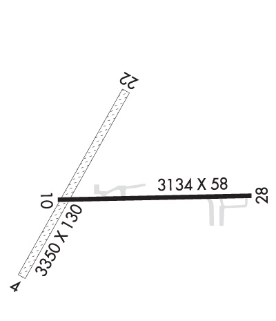
| Lat: N 4254.8 Long: W 07626.4 Elev: 1039 Var: +12 Longest Runway: 3350 | ||
| CTAF: 122.8 | ||
| ||||||||||||||||||||||||||||||||||||||||||||
| ||||||||||||||||||||||||||||||||||||||||||||
| Rwy | Rwy | |||||||
| 3350x130 | 3350' | 3350x130 | 3350' | |||||
| 3134x58 | 2891' | 3134x58 | 3134' | |||||
| Runway ID | Single Wheel | Double Wheel | Double Tandem Wheel | Dual Double Wheel |
| 04/22 | N/A | N/A | N/A | N/A |
| 10/28 | 9,000 | N/A | N/A | N/A |
| These numbers are Advisory and are not limits. The Airport Manager should have more accurate Weight Limits | ||||
 Airport Diagram might not be current. | |
| Facility Name: | SKANEATELES AERO DROME |
| City Name: | SKANEATELES |
| County: | ONONDAGA |
| State abbrev: | NY |
| State Name: | NEW YORK |
| Ownership: | PRIVATELY OWNED |
| Use: | OPEN TO THE PUBLIC |
| Owner's Name: | SKANEATELES AERODROME LLC; WEBSITE ADDRESS: WWW.SKANEATELESAERODROME.COM |
| Address: | 333 W. WASHINGTON ST STE 600 |
| SYRACUSE, NY 13202 | |
| Owner's Phone: | (315) 200-1877 |
| Manager's Name: | DANIEL ARNOLD |
| Address: | 2984 BENSON ROAD |
| SKANEATELES, NY 13152 | |
| Phone: | 707-580-9240 |
| FAA Region: | EASTERN |
| FAA Field Office: | NYC |
| Date | Sunrise | Sunset |
|---|---|---|
| 06/08/26 Monday | 5:27 | 20:43 |
| 06/09/26 Tuesday | 5:27 | 20:43 |
| 06/10/26 Wednesday | 5:27 | 20:44 |
| 06/11/26 Thursday | 5:27 | 20:44 |
| 06/12/26 Friday | 5:26 | 20:45 |
| 06/13/26 Saturday | 5:26 | 20:45 |
| 06/14/26 Sunday | 5:26 | 20:46 |
| 06/15/26 Monday | 5:26 | 20:46 |
| 06/16/26 Tuesday | 5:26 | 20:47 |
| 06/17/26 Wednesday | 5:26 | 20:47 |
| 06/18/26 Thursday | 5:26 | 20:47 |
| 06/19/26 Friday | 5:27 | 20:48 |
| 06/20/26 Saturday | 5:27 | 20:48 |
| 06/21/26 Sunday | 5:27 | 20:48 |
| Airport Attendance Schedule | UNATNDD; CALL MGR |
| Airport Status | OPERATIONAL (This Status can change at any time - please check NOTAMS) |
| Airport Lighting Schedule | ACTVT MIRL RWY 10/28 - CTAF. |
| Airport Storage Available | Tie Downs, Hanger |
| Extra Services Available | NONE |
| Wind Indicator | YES - (lighted) |
| Control Tower | NO |
| CTAF Frequency | 122.800 |
| Unicom Frequency | 122.800 |
| Rotating Beacon Color | |
| Segmented Circle | NO |
| Landing Fee | NO |
| Airport Inspected | STATE - performed by STATE AERONAUTICAL PERSONNEL |
| Inspection Date | 07/15/2024 |
| Type of Fuel Available | Grade 100LL |
| Airframe Repair Service | None |
| Power Plant Repair Service | None |
| Latitude | N4254.8 |
| Longitude | W07626.4 (ESTIMATED) |
| Arpt Elevation | 1039ft (SURVEYED) |
| Magnetic Variation | 12W |
| 2 miles SW | of SKANEATELES |
| Traffic Pattern Altitude | 800 |
| Sectional Chart | NEW YORK |
| Operations (Reported) | Yearly | Avg. Daily |
|---|---|---|
| General Aviation Transient | 0 | 0 |
| General Aviation Local | 0 | 0 |
| Air Taxi | 0 | 0 |
| Commerical | 0 | 0 |
| Commuter | 0 | 0 |
| Military | 0 | 0 |
| Aircraft based on Field | |
|---|---|
| General Aviation Singles | 0 |
| General Aviation Multi | 0 |
| Jet Aircraft | 0 |
| General Aviation Helicopters | 0 |
| Military Aircraft | 0 |
| Gliders | 0 |
| Ultralights | 0 |
| FSS on field | NO |
| FSS tie-in | BUFFALO |
| FSS Phone | 1-800-WX-BRIEF |
| Who issues Notams | BUF |
| Notam D service at airport | YES |
| ARTCC Name | NEW YORK |
| Airport Certification | |
| Aircraft Rescue & Firefighting Index | None |
| Airport of Entry | No |
| Custom Landing Rights | No |
| Joint Civil/Military | No |
| Military Landing rights | No |
| THIS AIRPORT HAS BEEN SURVEYED BY THE NATIONAL GEODETIC SURVEY. |
| RWY 04/22 AVBL 15 MAY TO 15 OCT. |
| RY 28 TWO 55 FT POWER POLES 70 FT EITHER SIDE OF CNTRLN 700 FM THRESHOLD. |
| RY 10 3 FT FENCE 20 FT FM THLD ON BOTH SIDES 15 FT ROAD 30 FT FM THLD ON BOTH SIDES & 4 FT FENCE 80 FT FM THLD ON BOTH SIDES. -10 FT CULVERT/DITCH 50 FT LEFT OF CNTRLNE AT THRESHOLD. |
| FUEL AVBL 24 HRS SELF SER CREDIT CARD. |
| FOR CD CTC SYRACUSE APCH AT 315-455-6218. |
| RWY 04/2 2 HAS VARIATIONS IN RWY SFC. |
| RWY 10/2 8 RWY 10/28 NSTD MIRL; LGTS ARE 38 FT FM PAVEMENT EDGE. |
Airport Communications & Frequencies:
| ||||||||||||||
| Runway: 04 | Runway: 22 | ||
| Mag heading: | 37° | Mag heading: | 217° |
| Rwy Slope: | -.81% Down | Rwy Slope: | .81% Up |
| Approach: | Approach: | ||
| Pattern: | Left Traffic | Pattern: | Left Traffic |
| Markings: | Markings: | ||
| Marking Condition: | Marking Condition: | ||
| Arresting Dev: | Arresting Dev: | ||
| Lat & Long: | N4254.6 W07626.7 | Lat. & Long.: | N4255.1 W07626.4 |
| Elev: | 1039.0 ft. MSL | Elev: | 1012.0 ft. MSL |
| TCH: | TCH: | ||
| Visual Glide Path: | Visual Glide Path: | ||
| Displaced Threshold: | No | Displaced Threshold: | No |
| Touchdown Zone: | YES | Touchdown Zone: | YES |
| Touchdown Elev.: | 1039.0 feet | Touchdown Elev.: | 1039.0 feet |
| Visual Glide Slope: | Visual Glide Slope: | ||
| RVR Equipment: | RVR Equipment: | ||
| RVV Equipment: | NO | RVV Equipment: | NO |
| Approach Lights: | Approach Lights: | ||
| REIL: | NO | REIL: | NO |
| Centerline Lights: | NO | Centerline Lights: | NO |
| Touchdown lights: | NO | Touchdown lights: | NO |
| Runway Category: | Runway with a Visual Approach | Runway Category: | Runway with a Visual Approach |
| Declared Distances: | Declared Distances: | ||
| Obstructions: | TREES; RWY 22 FENCE CROSSES RWY 10 FT FM THR BLO RWY ELEV. | Obstructions: | FENCE |
| Marked: | NOT Marked/Lighted | Marked: | NOT Marked/Lighted |
| Clearance slope: | 1:1 | Clearance slope: | 2:1 |
| Obstruction height: | 37 feet AGL | Obstruction height: | 30 feet AGL |
| Dist. from runway: | 56 feet | Dist. from runway: | 69 feet |
| Centerline offset: | 80 left of centerline | Centerline offset: | 82 feet right of centerline |
| Comments: | Comments: |
| Runway: 10 | Runway: 28 | ||
| Mag heading: | 107° | Mag heading: | 287° |
| Rwy Slope: | -.38% Down | Rwy Slope: | .38% Up |
| Approach: | Approach: | ||
| Pattern: | Left Traffic | Pattern: | Left Traffic |
| Markings: | BASIC | Markings: | BASIC |
| Marking Condition: | GOOD | Marking Condition: | GOOD |
| Arresting Dev: | Arresting Dev: | ||
| Lat & Long: | N4254.8 W07626.6 | Lat. & Long.: | N4254.8 W07625.9 |
| Elev: | 1006.0 ft. MSL | Elev: | 994.0 ft. MSL |
| TCH: | TCH: | ||
| Visual Glide Path: | Visual Glide Path: | ||
| Displaced Threshold: | 243 feet | Displaced Threshold: | No |
| Touchdown Zone: | YES | Touchdown Zone: | YES |
| Touchdown Elev.: | 1003.0 feet | Touchdown Elev.: | 1003.0 feet |
| Visual Glide Slope: | Visual Glide Slope: | ||
| RVR Equipment: | RVR Equipment: | ||
| RVV Equipment: | NO | RVV Equipment: | NO |
| Approach Lights: | Approach Lights: | ||
| REIL: | YES | REIL: | YES |
| Centerline Lights: | NO | Centerline Lights: | NO |
| Touchdown lights: | NO | Touchdown lights: | NO |
| Runway Category: | Runway with a Visual Approach | Runway Category: | Runway with a Visual Approach |
| Declared Distances: | Declared Distances: | ||
| Obstructions: | TREES | Obstructions: | TREES |
| Marked: | NOT Marked/Lighted | Marked: | NOT Marked/Lighted |
| Clearance slope: | 4:1 | Clearance slope: | 1:1 |
| Obstruction height: | 59 feet AGL | Obstruction height: | 51 feet AGL |
| Dist. from runway: | 440 feet | Dist. from runway: | 265 feet |
| Centerline offset: | 78 right of centerline | Centerline offset: | 113 feet right of centerline |
| Comments: | RWY 10 TWO 30 FT PWR POLES 80 FT EITHER SIDE OF CNTRLN 60 FT FM THLD; 3 FT FENCE OB 20 FT FM THLD 15 FT ROAD OB 30 FT FM THLD. 4 FT FENCE OB 80 FT FM THLD. | Comments: | RWY 28 33 FT TREE 138 FT FM RWY 120 FT RIGHT; 10 FT FARM ROAD CROSSES APPROACH END 117 FT FM THR. |
Thanks for using FltPlan.com
all rights reserved © 1999-2026 by Flight Plan LLC