
| JOHNSON COUNTY MOUNTAIN CITY TN |
| |
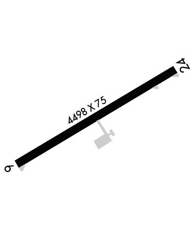
| Lat: N 3625.1 Long: W 08149.5 Elev: 2241 Var: +07 Longest Runway: 4498 | ||
| AWOS: 126.22 CTAF: 122.7 | ||
| ||||||
| ||||||
|
| Rwy | Rwy | |||||||
| 4498x75 | 4498' | 4498x75 | 4498' | |||||
| Runway ID | Single Wheel | Double Wheel | Double Tandem Wheel | Dual Double Wheel |
| 07/25 | N/A | 26,000 | 37,000 | N/A |
| These numbers are Advisory and are not limits. The Airport Manager should have more accurate Weight Limits | ||||
 Airport Diagram might not be current. | |
| Facility Name: | JOHNSON COUNTY |
| City Name: | MOUNTAIN CITY |
| County: | JOHNSON |
| State abbrev: | TN |
| State Name: | TENNESSEE |
| Ownership: | PUBLICLY OWNED |
| Use: | OPEN TO THE PUBLIC |
| Owner's Name: | JOHNSON COUNTY |
| Address: | CO COURTHSE; 222 W MAIN ST |
| MOUNTAIN CITY, TN 37683 | |
| Owner's Phone: | 423-727-9696 |
| Manager's Name: | DAVE GARRIS |
| Address: | 611 AIRPORT ROAD |
| MOUNTAIN CITY, TN 37683 | |
| Phone: | 423-727-1223 |
| FAA Region: | SOUTHERN |
| FAA Field Office: | MEM |
| Date | Sunrise | Sunset |
|---|---|---|
| 06/15/26 Monday | 6:09 | 20:47 |
| 06/16/26 Tuesday | 6:09 | 20:47 |
| 06/17/26 Wednesday | 6:09 | 20:47 |
| 06/18/26 Thursday | 6:09 | 20:48 |
| 06/19/26 Friday | 6:09 | 20:48 |
| 06/20/26 Saturday | 6:09 | 20:48 |
| 06/21/26 Sunday | 6:10 | 20:48 |
| 06/22/26 Monday | 6:10 | 20:49 |
| 06/23/26 Tuesday | 6:10 | 20:49 |
| 06/24/26 Wednesday | 6:10 | 20:49 |
| 06/25/26 Thursday | 6:11 | 20:49 |
| 06/26/26 Friday | 6:11 | 20:49 |
| 06/27/26 Saturday | 6:11 | 20:49 |
| 06/28/26 Sunday | 6:12 | 20:49 |
| Airport Attendance Schedule | 7 Days A Week 0900-1800; AFT HR & SVC - AMGR. |
| Airport Status | OPERATIONAL (This Status can change at any time - please check NOTAMS) |
| Airport Lighting Schedule | ACTVT PAPI RWY 07 & 25; MIRL RWY 07/25 - CTAF. |
| Airport Storage Available | Tie Downs, Hanger |
| Extra Services Available | Avionics, Glider, Flight Instruction, Parachute Jumping, Aircraft Rental |
| Wind Indicator | YES - (lighted) |
| Control Tower | NO |
| CTAF Frequency | 122.700 |
| Unicom Frequency | 122.700 |
| Rotating Beacon Color | |
| Segmented Circle | YES |
| Landing Fee | NO |
| Airport Inspected | STATE - performed by STATE AERONAUTICAL PERSONNEL |
| Inspection Date | 06/02/2025 |
| Type of Fuel Available | Grade 100LL, JET A |
| Airframe Repair Service | MAJOR |
| Power Plant Repair Service | MAJOR |
| Latitude | N3625.1 |
| Longitude | W08149.5 (ESTIMATED) |
| Arpt Elevation | 2241ft (ESTIMATED) |
| Magnetic Variation | 07W |
| 4 miles S | of MOUNTAIN CITY |
| Traffic Pattern Altitude | |
| Sectional Chart | CINCINNATI |
| Operations (Reported) | Yearly | Avg. Daily |
|---|---|---|
| General Aviation Transient | 0 | 0 |
| General Aviation Local | 0 | 0 |
| Air Taxi | 0 | 0 |
| Commerical | 0 | 0 |
| Commuter | 0 | 0 |
| Military | 0 | 0 |
| Aircraft based on Field | |
|---|---|
| General Aviation Singles | 0 |
| General Aviation Multi | 0 |
| Jet Aircraft | 0 |
| General Aviation Helicopters | 0 |
| Military Aircraft | 0 |
| Gliders | 0 |
| Ultralights | 0 |
| FSS on field | NO |
| FSS tie-in | NASHVILLE |
| FSS Phone | 1-800-WX-BRIEF |
| Who issues Notams | BNA |
| Notam D service at airport | YES |
| ARTCC Name | ATLANTA |
| Airport Certification | |
| Aircraft Rescue & Firefighting Index | None |
| Airport of Entry | No |
| Custom Landing Rights | No |
| Joint Civil/Military | No |
| Military Landing rights | YES |
| NATIONAL PLAN OF INTEGRATED AIRPORT SYSTEMS (NPIAS) |
| GRANT AGREEMENTS UNDER FAAP/ADAP/AIP |
| ASSURANCES PURSUANT TO TITLE VI, CIVIL RIGHTS ACT OF 1964 |
| MT TRRN & HIGH PEAKS ALL QUADS; TSNT NIGHT OPS NOT RCMDD. |
| DEER & BIRDS INVOF ARPT. |
| COLD TEMPERATURE AIRPORT. ALTITUDE CORRECTION REQUIRED AT OR BELOW -9C. |
| FOR CD CTC ATLANTA ARTCC AT 770-210-7692. |
Airport Communications & Frequencies:
| |||||||||||||||||
| Runway: 07 | Runway: 25 | ||
| Mag heading: | 65° | Mag heading: | 245° |
| Rwy Slope: | .02% Up | Rwy Slope: | -.02% Down |
| Approach: | Approach: | ||
| Pattern: | Right Traffic | Pattern: | Left Traffic |
| Markings: | NONPRECISION INSTRUMENT | Markings: | NONPRECISION INSTRUMENT |
| Marking Condition: | GOOD | Marking Condition: | GOOD |
| Arresting Dev: | Arresting Dev: | ||
| Lat & Long: | N3624.9 W08149.9 | Lat. & Long.: | N3625.3 W08149.1 |
| Elev: | 2240.3 ft. MSL | Elev: | 2241.1 ft. MSL |
| TCH: | 55 ft. AGL | TCH: | 39 ft. AGL |
| Visual Glide Path: | 4.00 degrees | Visual Glide Path: | 4.00 degrees |
| Displaced Threshold: | No | Displaced Threshold: | No |
| Touchdown Zone: | YES | Touchdown Zone: | YES |
| Touchdown Elev.: | 2240.3 feet | Touchdown Elev.: | 2241.1 feet |
| Visual Glide Slope: | 2-Light PAPI on LEFT side of Runway; RWY 07 PAPI DOES NOT PRVD OBSTN CLNC BYD 1.4 NM FM THR. PAPI RWY 07 UNUSBL BYD 5 DEGS LEFT OF CNTRLN. | Visual Glide Slope: | 2-Light PAPI on LEFT side of Runway; PAPI RWY 25 DOES NOT PRVD OBSTN CLNC BYD 1.4 NM FM THR. RWY 25 PAPI UNUSBL BYD 8 DEGS LEFT OF CNTRLN. |
| RVR Equipment: | RVR Equipment: | ||
| RVV Equipment: | NO | RVV Equipment: | NO |
| Approach Lights: | Approach Lights: | ||
| REIL: | NO | REIL: | NO |
| Centerline Lights: | NO | Centerline Lights: | NO |
| Touchdown lights: | NO | Touchdown lights: | NO |
| Runway Category: | Runway with a Non-precision Approach | Runway Category: | Runway with a Non-precision Approach |
| Declared Distances: | Declared Distances: | ||
| Obstructions: | TREE | Obstructions: | TREE |
| Marked: | NOT Marked/Lighted | Marked: | NOT Marked/Lighted |
| Clearance slope: | 17:1 | Clearance slope: | 16:1 |
| Obstruction height: | 34 feet AGL | Obstruction height: | 97 feet AGL |
| Dist. from runway: | 784 feet | Dist. from runway: | 1797 feet |
| Centerline offset: | 193 left of centerline | Centerline offset: | 423 feet right of centerline |
| Comments: | Comments: |
Thanks for using FltPlan.com
all rights reserved © 1999-2026 by Flight Plan LLC
