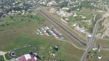
| COLVILLE MUNI COLVILLE WA |
| |
| Lat: N 4832.7 Long: W 11753.0 Elev: 1888 Var: -20 Longest Runway: 2695 | ||
| CTAF: 122.8 | ||
| |||||||||||||||||||||||
| |||||||||||||||||||||||
| Rwy | Rwy | |||||||
| 2695x40 | 2695' | 2695x40 | 2695' | |||||
| Runway ID | Single Wheel | Double Wheel | Double Tandem Wheel | Dual Double Wheel |
| 01/19 | 11,000 | N/A | N/A | N/A |
| These numbers are Advisory and are not limits. The Airport Manager should have more accurate Weight Limits | ||||
| FltPlan does not have IFR approach charts available for K63S. |
| Facility Name: | COLVILLE MUNI |
| City Name: | COLVILLE |
| County: | STEVENS |
| State abbrev: | WA |
| State Name: | WASHINGTON |
| Ownership: | PUBLICLY OWNED |
| Use: | OPEN TO THE PUBLIC |
| Owner's Name: | CITY OF COLVILLE |
| Address: | CITY HALL 170 S OAK ST |
| COLVILLE, WA 99114 | |
| Owner's Phone: | 509-684-5094 |
| Manager's Name: | DAVID GARRINGER; ALTERNATE PHONE 509-684-1566. |
| Address: | 173-A N. AIRPORT DR |
| COLVILLE, WA 99114 | |
| Phone: | 509-685-9056; ALTERNATE PHONE 509-675-1041 |
| FAA Region: | NORTHWEST MOUNTAIN |
| FAA Field Office: | SEA |
| Date | Sunrise | Sunset |
|---|---|---|
| 09/24/21 Friday | 6:41 | 18:45 |
| 09/25/21 Saturday | 6:42 | 18:43 |
| 09/26/21 Sunday | 6:44 | 18:41 |
| 09/27/21 Monday | 6:45 | 18:39 |
| 09/28/21 Tuesday | 6:46 | 18:37 |
| 09/29/21 Wednesday | 6:48 | 18:35 |
| 09/30/21 Thursday | 6:49 | 18:33 |
| 10/01/21 Friday | 6:51 | 18:31 |
| 10/02/21 Saturday | 6:52 | 18:29 |
| 10/03/21 Sunday | 6:54 | 18:27 |
| 10/04/21 Monday | 6:55 | 18:25 |
| 10/05/21 Tuesday | 6:57 | 18:23 |
| 10/06/21 Wednesday | 6:58 | 18:20 |
| 10/07/21 Thursday | 6:59 | 18:18 |
| Airport Attendance Schedule | MON-FRI 0800-1700 |
| Airport Status | OPERATIONAL (This Status can change at any time - please check NOTAMS) |
| Airport Lighting Schedule | ACTVT MIRL RY 01/19 - CTAF. |
| Airport Storage Available | Tie Downs |
| Extra Services Available | Flight Instruction |
| Wind Indicator | YES - (unlit) |
| Control Tower | NO |
| CTAF Frequency | 122.800 |
| Unicom Frequency | 122.800 |
| Rotating Beacon Color | CLEAR-GREEN (Light Land Airport) |
| Segmented Circle | NO |
| Landing Fee | NO |
| Airport Inspected | STATE - performed by STATE AERONAUTICAL PERSONNEL |
| Inspection Date | 08/13/2019 |
| Type of Fuel Available | Grade 100LL |
| Airframe Repair Service | NONE |
| Power Plant Repair Service | NONE |
| Latitude | N4832.7 |
| Longitude | W11753.0 (ESTIMATED) |
| Arpt Elevation | 1888ft (ESTIMATED) |
| Magnetic Variation | 20E |
| 1 miles E | of COLVILLE |
| Traffic Pattern Altitude | |
| Sectional Chart | SEATTLE |
| Operations (Reported) | Yearly | Avg. Daily |
|---|---|---|
| General Aviation Transient | 1000 | 3 |
| General Aviation Local | 5550 | 15 |
| Air Taxi | 0 | 0 |
| Commerical | 0 | 0 |
| Commuter | 0 | 0 |
| Military | 0 | 0 |
| Aircraft based on Field | |
|---|---|
| General Aviation Singles | 25 |
| General Aviation Multi | 2 |
| Jet Aircraft | 0 |
| General Aviation Helicopters | 0 |
| Military Aircraft | 0 |
| Gliders | 0 |
| Ultralights | 0 |
| FSS on field | NO |
| FSS tie-in | SEATTLE |
| FSS Phone | 1-800-WX-BRIEF |
| Who issues Notams | SEA |
| Notam D service at airport | YES |
| ARTCC Name | SEATTLE |
| Airport Certification | |
| Aircraft Rescue & Firefighting Index | None |
| Airport of Entry | No |
| Custom Landing Rights | No |
| Joint Civil/Military | No |
| Military Landing rights | No |
| NATIONAL PLAN OF INTEGRATED AIRPORT SYSTEMS (NPIAS) |
| GRANT AGREEMENTS UNDER FAAP/ADAP/AIP |
| ASSURANCES PURSUANT TO TITLE VI, CIVIL RIGHTS ACT OF 1964 |
| WATCH FOR DEER ON AND IN THE VICINITY OF ARPT. |
| APN & TIEDOWN GRVL; 3 ASPH PAVED TRANSIENT TIEDOWNS WESTSIDE. EASTSIDE TIEDOWNS GRAVEL. |
| OCNL VEHICULAR TFC ACROSS END OF RY 01/19 & TWY. |
| 2 CARS AVBL. |
| WHEN LANDING RY 19, BRIGHT LIGHTS AROUND HIGH SCHOOL STADIUM, APPROXIMATELY 3/4 MILES 'S' OF ARPT. |
| GRASS LDG AREA AVL ACROSS RY 1/19 1500 FT X 150 FT. HAZARDS ARE 50 FT OBSTRUCTIONS ON BOTH ENDS, TREES/POLES |
| FOR CD CTC SEATTLE ARTCC AT 253-351-3694. |
| RWY 01/1 9 RWY 19 DTHR 255 FT. |
| Runway: 01 | Runway: 19 | ||
| Mag heading: | N/A | Mag heading: | N/A |
| Rwy Slope: | .71% Up | Rwy Slope: | -.71% Down |
| Approach: | Approach: | ||
| Pattern: | Left Traffic | Pattern: | Left Traffic |
| Markings: | BASIC | Markings: | BASIC |
| Marking Condition: | FAIR | Marking Condition: | FAIR |
| Arresting Dev: | Arresting Dev: | ||
| Lat & Long: | N4832.5 W11753.2 | Lat. & Long.: | N4832.8 W11752.8 |
| Elev: | 1869.0 ft. MSL | Elev: | 1888.0 ft. MSL |
| TCH: | TCH: | ||
| Visual Glide Path: | Visual Glide Path: | ||
| Displaced Threshold: | No | Displaced Threshold: | No |
| Touchdown Zone: | YES | Touchdown Zone: | YES |
| Touchdown Elev.: | 1888.0 feet | Touchdown Elev.: | 1888.0 feet |
| Visual Glide Slope: | Visual Glide Slope: | ||
| RVR Equipment: | RVR Equipment: | ||
| RVV Equipment: | NO | RVV Equipment: | NO |
| Approach Lights: | Approach Lights: | ||
| REIL: | NO | REIL: | NO |
| Centerline Lights: | NO | Centerline Lights: | NO |
| Touchdown lights: | NO | Touchdown lights: | NO |
| Runway Category: | Runway with a Visual Approach | Runway Category: | Runway with a Visual Approach |
| Declared Distances: | Declared Distances: | ||
| Obstructions: | Obstructions: | TREE | |
| Marked: | Marked: | NOT Marked/Lighted | |
| Clearance slope: | 50:1 | Clearance slope: | 1:1; RWY 19 APCH RATIO 12:1 TO +50' TREE @ 300', 25' L FROM DSPLCD THLD. |
| Obstruction height: | Obstruction height: | 58 feet AGL | |
| Dist. from runway: | Dist. from runway: | 249 feet | |
| Centerline offset: | Centerline offset: | 23 feet right of centerline | |
| Comments: | RWY 01 6 FT FENCE AT END OF RWY, 113 R FM RWY EDGE. | Comments: | RWY 19 +6 FT FENCE & ROAD 66 FT FM THR; BLDG 170 FT FM THR, 36 FT R. |
Thanks for using FltPlan.com
all rights reserved © 1999-2021 by Flight Plan LLC