
| ADAMS COUNTY LEGION FIELD FRIENDSHIP (ADAMS) WI |
| |
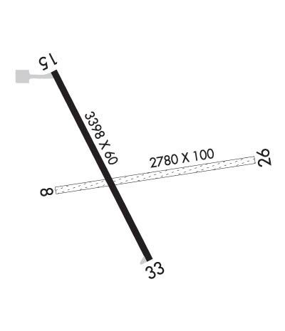
| Lat: N 4357.6 Long: W 08947.3 Elev: 979 Var: +01 Longest Runway: 3398 | ||
| CTAF: 122.9 | ||
| ||||||||||||||||||||||||||||||||||||||||||||
| ||||||||||||||||||||||||||||||||||||||||||||
| Rwy | Rwy | |||||||
| 2780x100 | 2780' | 2780x100 | 2780' | |||||
| 3398x60 | 3398' | 3398x60 | 3398' | |||||
| Runway ID | Single Wheel | Double Wheel | Double Tandem Wheel | Dual Double Wheel |
| 08/26 | N/A | N/A | N/A | N/A |
| 15/33 | 12,500 | N/A | N/A | N/A |
| These numbers are Advisory and are not limits. The Airport Manager should have more accurate Weight Limits | ||||
 Airport Diagram might not be current. | |
| Facility Name: | ADAMS COUNTY LEGION FLD |
| City Name: | FRIENDSHIP (ADAMS) |
| County: | ADAMS |
| State abbrev: | WI |
| State Name: | WISCONSIN |
| Ownership: | PUBLICLY OWNED |
| Use: | OPEN TO THE PUBLIC |
| Owner's Name: | ADAMS COUNTY |
| Address: | PO BOX 278 |
| FRIENDSHIP, WI 53934 | |
| Owner's Phone: | 608-339-4200 |
| Manager's Name: | MIKE SCOTT |
| Address: | PO BOX 819 |
| ADAMS, WI 53910 | |
| Phone: | (608) 547-1303 |
| FAA Region: | GREAT LAKES |
| FAA Field Office: | CHI |
| Date | Sunrise | Sunset |
|---|---|---|
| 09/24/21 Friday | 6:48 | 18:53 |
| 09/25/21 Saturday | 6:49 | 18:51 |
| 09/26/21 Sunday | 6:51 | 18:50 |
| 09/27/21 Monday | 6:52 | 18:48 |
| 09/28/21 Tuesday | 6:53 | 18:46 |
| 09/29/21 Wednesday | 6:54 | 18:44 |
| 09/30/21 Thursday | 6:55 | 18:42 |
| 10/01/21 Friday | 6:56 | 18:40 |
| 10/02/21 Saturday | 6:58 | 18:39 |
| 10/03/21 Sunday | 6:59 | 18:37 |
| 10/04/21 Monday | 7:00 | 18:35 |
| 10/05/21 Tuesday | 7:01 | 18:33 |
| 10/06/21 Wednesday | 7:02 | 18:31 |
| 10/07/21 Thursday | 7:04 | 18:30 |
| Airport Attendance Schedule | UNATTENDED |
| Airport Status | OPERATIONAL (This Status can change at any time - please check NOTAMS) |
| Airport Lighting Schedule | ACTVT REILS RY 15/33; MIRL RY 15/33 - CTAF. |
| Airport Storage Available | Tie Downs |
| Extra Services Available | NONE |
| Wind Indicator | YES - (lighted) |
| Control Tower | NO |
| CTAF Frequency | 122.900 |
| Unicom Frequency | |
| Rotating Beacon Color | CLEAR-GREEN (Light Land Airport) |
| Segmented Circle | YES |
| Landing Fee | NO |
| Airport Inspected | STATE - performed by STATE AERONAUTICAL PERSONNEL |
| Inspection Date | 06/26/2019 |
| Type of Fuel Available | Grade 100LL; -10FUEL AVBL 24 HRS WITH CREDIT CARD. |
| Airframe Repair Service | NONE |
| Power Plant Repair Service | NONE |
| Latitude | N4357.6 |
| Longitude | W08947.3 (ESTIMATED) |
| Arpt Elevation | 979ft (SURVEYED) |
| Magnetic Variation | 01W |
| 1 miles E | of FRIENDSHIP (ADAMS) |
| Traffic Pattern Altitude | |
| Sectional Chart | CHICAGO |
| Operations (Reported) | Yearly | Avg. Daily |
|---|---|---|
| General Aviation Transient | 3000 | 8 |
| General Aviation Local | 4000 | 11 |
| Air Taxi | 50 | 0 |
| Commerical | 0 | 0 |
| Commuter | 0 | 0 |
| Military | 20 | 0 |
| Aircraft based on Field | |
|---|---|
| General Aviation Singles | 13 |
| General Aviation Multi | 0 |
| Jet Aircraft | 0 |
| General Aviation Helicopters | 0 |
| Military Aircraft | 0 |
| Gliders | 0 |
| Ultralights | 0 |
| FSS on field | NO |
| FSS tie-in | GREEN BAY |
| FSS Phone | 1-800-WX-BRIEF |
| Who issues Notams | GRB |
| Notam D service at airport | YES |
| ARTCC Name | CHICAGO |
| Airport Certification | |
| Aircraft Rescue & Firefighting Index | None |
| Airport of Entry | No |
| Custom Landing Rights | No |
| Joint Civil/Military | No |
| Military Landing rights | No |
| NATIONAL PLAN OF INTEGRATED AIRPORT SYSTEMS (NPIAS) |
| GRANT AGREEMENTS UNDER FAAP/ADAP/AIP |
| ASSURANCES PURSUANT TO TITLE VI, CIVIL RIGHTS ACT OF 1964 |
| ULTRALIGHT ACTVTY ON & IN VCNTY OF ARPT. |
| ACFT DEP RY 15 REQUESTED TO TURN TO A HEADING OF 180 DEGREES AFT TAKEOFF. |
| FOR CD CTC CHICAGO ARTCC AT 630-906-8921. |
| RWY 08/2 6 RY 08/26 CLSD DEC 1 - APR 1. |
Airport Communications & Frequencies:
| |||||||||||||||
| Runway: 08 | Runway: 26 | ||
| Mag heading: | 81° | Mag heading: | 261° |
| Rwy Slope: | .17% Up | Rwy Slope: | -.17% Down |
| Approach: | Approach: | ||
| Pattern: | Left Traffic | Pattern: | Left Traffic |
| Markings: | Markings: | ||
| Marking Condition: | 08/26 MKD WITH 3 FT WHITE CONES. | Marking Condition: | |
| Arresting Dev: | Arresting Dev: | ||
| Lat & Long: | N4357.6 W08947.6 | Lat. & Long.: | N4357.7 W08946.9 |
| Elev: | 973.5 ft. MSL | Elev: | 978.1 ft. MSL |
| TCH: | TCH: | ||
| Visual Glide Path: | Visual Glide Path: | ||
| Displaced Threshold: | No | Displaced Threshold: | No |
| Touchdown Zone: | YES | Touchdown Zone: | YES |
| Touchdown Elev.: | 978.9 feet | Touchdown Elev.: | 978.9 feet |
| Visual Glide Slope: | Visual Glide Slope: | ||
| RVR Equipment: | RVR Equipment: | ||
| RVV Equipment: | NO | RVV Equipment: | NO |
| Approach Lights: | Approach Lights: | ||
| REIL: | NO | REIL: | NO |
| Centerline Lights: | NO | Centerline Lights: | NO |
| Touchdown lights: | NO | Touchdown lights: | NO |
| Runway Category: | Runway with a Visual Approach | Runway Category: | Runway with a Visual Approach |
| Declared Distances: | Declared Distances: | ||
| Obstructions: | TREES | Obstructions: | TREES |
| Marked: | NOT Marked/Lighted | Marked: | NOT Marked/Lighted |
| Clearance slope: | 23:1 | Clearance slope: | 20:1 |
| Obstruction height: | 60 feet AGL | Obstruction height: | 60 feet AGL |
| Dist. from runway: | 1400 feet | Dist. from runway: | 1250 feet |
| Centerline offset: | 20 right of centerline | Centerline offset: | 200 feet left of centerline |
| Comments: | Comments: |
| Runway: 15 | Runway: 33 | ||
| Mag heading: | 154° | Mag heading: | 334° |
| Rwy Slope: | .31% Up | Rwy Slope: | -.31% Down |
| Approach: | Approach: | ||
| Pattern: | Left Traffic | Pattern: | Left Traffic |
| Markings: | NONPRECISION INSTRUMENT | Markings: | NONPRECISION INSTRUMENT |
| Marking Condition: | GOOD | Marking Condition: | GOOD |
| Arresting Dev: | Arresting Dev: | ||
| Lat & Long: | N4357.9 W08947.6 | Lat. & Long.: | N4357.4 W08947.2 |
| Elev: | 968.4 ft. MSL | Elev: | 979.0 ft. MSL |
| TCH: | 23 ft. AGL | TCH: | 20 ft. AGL |
| Visual Glide Path: | 3.00 degrees | Visual Glide Path: | 3.00 degrees |
| Displaced Threshold: | No | Displaced Threshold: | No |
| Touchdown Zone: | YES | Touchdown Zone: | YES |
| Touchdown Elev.: | 978.4 feet | Touchdown Elev.: | 979.2 feet |
| Visual Glide Slope: | 2-Light PAPI on LEFT side of Runway; OPERATE CONTINUOUSLY. | Visual Glide Slope: | 2-Light PAPI on LEFT side of Runway; OPERATE CONTINUOUSLY. |
| RVR Equipment: | RVR Equipment: | ||
| RVV Equipment: | NO | RVV Equipment: | NO |
| Approach Lights: | Approach Lights: | ||
| REIL: | YES | REIL: | YES |
| Centerline Lights: | NO | Centerline Lights: | NO |
| Touchdown lights: | NO | Touchdown lights: | NO |
| Runway Category: | Runway with a Visual Approach | Runway Category: | Runway with a Non-precision Approach |
| Declared Distances: | Declared Distances: | ||
| Obstructions: | TREES | Obstructions: | TREES |
| Marked: | NOT Marked/Lighted | Marked: | NOT Marked/Lighted |
| Clearance slope: | 15:1 | Clearance slope: | 12:1 |
| Obstruction height: | 52 feet AGL | Obstruction height: | 50 feet AGL |
| Dist. from runway: | 980 feet | Dist. from runway: | 800 feet |
| Centerline offset: | 175 right of centerline | Centerline offset: | 250 feet right of centerline |
| Comments: | Comments: |
Thanks for using FltPlan.com
all rights reserved © 1999-2021 by Flight Plan LLC
