
| NEWTON MUNI NEWTON TX |
| |
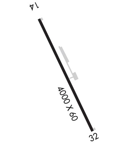
| Lat: N 3053.0 Long: W 09344.5 Elev: 322 Var: -05 Longest Runway: 4000 | ||
| CTAF: 122.8 | ||
| ||||||||||||||||||||||||||||||||
| ||||||||||||||||||||||||||||||||
| Rwy | Rwy | |||||||
| 4000x60 | 4000' | 4000x60 | 4000' | |||||
| Runway ID | Single Wheel | Double Wheel | Double Tandem Wheel | Dual Double Wheel |
| 14/32 | 12,500 | N/A | N/A | N/A |
| These numbers are Advisory and are not limits. The Airport Manager should have more accurate Weight Limits | ||||
| FltPlan does not have IFR approach charts available for K61R. |
 Airport Diagram might not be current. | |
| Facility Name: | NEWTON MUNI |
| City Name: | NEWTON |
| County: | NEWTON |
| State abbrev: | TX |
| State Name: | TEXAS |
| Ownership: | PUBLICLY OWNED |
| Use: | OPEN TO THE PUBLIC |
| Owner's Name: | NEWTON COUNTY |
| Address: | PO BOX 1380 |
| NEWTON, TX 75966 | |
| Owner's Phone: | 409-379-5691 |
| Manager's Name: | KENNETH WEEKS; COUNTY JUDGE/AMGR |
| Address: | PO BOX 1380 |
| NEWTON, TX 75966 | |
| Phone: | 409-379-5691; AFTR HRS AMGR PH 409-384-0722 |
| FAA Region: | SOUTHWEST |
| FAA Field Office: | TEX |
| Date | Sunrise | Sunset |
|---|---|---|
| 09/24/21 Friday | 7:04 | 19:09 |
| 09/25/21 Saturday | 7:05 | 19:08 |
| 09/26/21 Sunday | 7:05 | 19:07 |
| 09/27/21 Monday | 7:06 | 19:05 |
| 09/28/21 Tuesday | 7:07 | 19:04 |
| 09/29/21 Wednesday | 7:07 | 19:03 |
| 09/30/21 Thursday | 7:08 | 19:02 |
| 10/01/21 Friday | 7:08 | 19:00 |
| 10/02/21 Saturday | 7:09 | 18:59 |
| 10/03/21 Sunday | 7:10 | 18:58 |
| 10/04/21 Monday | 7:10 | 18:57 |
| 10/05/21 Tuesday | 7:11 | 18:55 |
| 10/06/21 Wednesday | 7:12 | 18:54 |
| 10/07/21 Thursday | 7:12 | 18:53 |
| Airport Attendance Schedule | UNATTENDED |
| Airport Status | OPERATIONAL (This Status can change at any time - please check NOTAMS) |
| Airport Lighting Schedule | SS-SR |
| Airport Storage Available | NONE |
| Extra Services Available | NONE |
| Wind Indicator | YES - (lighted) |
| Control Tower | NO |
| CTAF Frequency | 122.800 |
| Unicom Frequency | 122.800 |
| Rotating Beacon Color | CLEAR-GREEN (Light Land Airport) |
| Segmented Circle | YES |
| Landing Fee | NO |
| Airport Inspected | STATE - performed by PRIVATE CONTRACT PERSONNEL |
| Inspection Date | 04/20/2020 |
| Type of Fuel Available | None |
| Airframe Repair Service | None |
| Power Plant Repair Service | None |
| Latitude | N3053.0 |
| Longitude | W09344.5 (ESTIMATED) |
| Arpt Elevation | 322ft (ESTIMATED) |
| Magnetic Variation | 05E |
| 3 miles NE | of NEWTON |
| Traffic Pattern Altitude | |
| Sectional Chart | HOUSTON |
| Operations (Reported) | Yearly | Avg. Daily |
|---|---|---|
| General Aviation Transient | 200 | 1 |
| General Aviation Local | 600 | 2 |
| Air Taxi | 0 | 0 |
| Commerical | 0 | 0 |
| Commuter | 0 | 0 |
| Military | 0 | 0 |
| Aircraft based on Field | |
|---|---|
| General Aviation Singles | 1 |
| General Aviation Multi | 0 |
| Jet Aircraft | 0 |
| General Aviation Helicopters | 0 |
| Military Aircraft | 0 |
| Gliders | 0 |
| Ultralights | 2 |
| FSS on field | NO |
| FSS tie-in | MONTGOMERY COUNTY |
| FSS Phone | 1-800-WX-BRIEF |
| Who issues Notams | CXO |
| Notam D service at airport | YES |
| ARTCC Name | HOUSTON |
| Airport Certification | |
| Aircraft Rescue & Firefighting Index | None |
| Airport of Entry | No |
| Custom Landing Rights | No |
| Joint Civil/Military | No |
| Military Landing rights | No |
| FOR CD CTC POLK APCH AT 337-531-2352. |
| RWY 14/3 2 RWY SFC ROUGH. SOME POT HOLES. |
| Runway: 14 | Runway: 32 | ||
| Mag heading: | 140° | Mag heading: | 320° |
| Rwy Slope: | -.93% Down | Rwy Slope: | .93% Up |
| Approach: | Approach: | ||
| Pattern: | Left Traffic | Pattern: | Left Traffic |
| Markings: | BASIC | Markings: | BASIC |
| Marking Condition: | POOR; MARKINGS FADED. | Marking Condition: | POOR; MARKINGS FADED |
| Arresting Dev: | Arresting Dev: | ||
| Lat & Long: | N3053.3 W09344.8 | Lat. & Long.: | N3052.8 W09344.3 |
| Elev: | 322.0 ft. MSL | Elev: | 285.0 ft. MSL |
| TCH: | TCH: | ||
| Visual Glide Path: | Visual Glide Path: | ||
| Displaced Threshold: | No | Displaced Threshold: | No |
| Touchdown Zone: | NO | Touchdown Zone: | NO |
| Touchdown Elev.: | Touchdown Elev.: | ||
| Visual Glide Slope: | Visual Glide Slope: | ||
| RVR Equipment: | RVR Equipment: | ||
| RVV Equipment: | NO | RVV Equipment: | NO |
| Approach Lights: | Approach Lights: | ||
| REIL: | NO | REIL: | NO |
| Centerline Lights: | NO | Centerline Lights: | NO |
| Touchdown lights: | NO | Touchdown lights: | NO |
| Runway Category: | Runway with a Visual Approach | Runway Category: | Runway with a Visual Approach |
| Declared Distances: | Declared Distances: | ||
| Obstructions: | TREES | Obstructions: | TREES |
| Marked: | NOT Marked/Lighted | Marked: | NOT Marked/Lighted |
| Clearance slope: | 29:1 | Clearance slope: | 10:1 |
| Obstruction height: | 50 feet AGL | Obstruction height: | 75 feet AGL |
| Dist. from runway: | 1650 feet | Dist. from runway: | 975 feet |
| Centerline offset: | Centerline offset: | 165 feet left of centerline | |
| Comments: | Comments: |
Thanks for using FltPlan.com
all rights reserved © 1999-2021 by Flight Plan LLC
