
| ALBERT J LINDBERG HESSEL MI |
| |
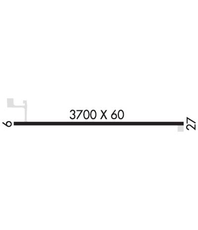
| Lat: N 4602.1 Long: W 08425.1 Elev: 760 Var: +06 Longest Runway: 3700 | ||
| CTAF: 122.9 | ||
| ||||||
|
| Rwy | Rwy | |||||||
| 3700x60 | 3513' | 3700x60 | 3700' | |||||
| Runway ID | Single Wheel | Double Wheel | Double Tandem Wheel | Dual Double Wheel |
| 09/27 | 30,000 | 60,000 | N/A | N/A |
| These numbers are Advisory and are not limits. The Airport Manager should have more accurate Weight Limits | ||||
| FltPlan does not have IFR approach charts available for K5Y1. |
 Airport Diagram might not be current. | |
| Facility Name: | ALBERT J LINDBERG |
| City Name: | HESSEL |
| County: | MACKINAC |
| State abbrev: | MI |
| State Name: | MICHIGAN |
| Ownership: | PUBLICLY OWNED |
| Use: | OPEN TO THE PUBLIC |
| Owner's Name: | CLARK TOWNSHIP |
| Address: | PO BOX 367 |
| CEDARVILLE, MI 49719 | |
| Owner's Phone: | 906-484-2672 |
| Manager's Name: | JOSEPH BAKER |
| Address: | P.O. BOX 367 |
| CEDARVILLE, MI 49719 | |
| Phone: | 906-430-8034; 906-484-2672. |
| FAA Region: | GREAT LAKES |
| FAA Field Office: | DET |
| Date | Sunrise | Sunset |
|---|---|---|
| 09/24/21 Friday | 7:27 | 19:32 |
| 09/25/21 Saturday | 7:28 | 19:30 |
| 09/26/21 Sunday | 7:29 | 19:28 |
| 09/27/21 Monday | 7:31 | 19:26 |
| 09/28/21 Tuesday | 7:32 | 19:24 |
| 09/29/21 Wednesday | 7:33 | 19:22 |
| 09/30/21 Thursday | 7:34 | 19:20 |
| 10/01/21 Friday | 7:36 | 19:18 |
| 10/02/21 Saturday | 7:37 | 19:16 |
| 10/03/21 Sunday | 7:38 | 19:14 |
| 10/04/21 Monday | 7:40 | 19:12 |
| 10/05/21 Tuesday | 7:41 | 19:10 |
| 10/06/21 Wednesday | 7:42 | 19:09 |
| 10/07/21 Thursday | 7:44 | 19:07 |
| Airport Attendance Schedule | UNATTENDED |
| Airport Status | OPERATIONAL (This Status can change at any time - please check NOTAMS) |
| Airport Lighting Schedule | ACTVT PAPI RWY 09 & 27; MIRL RWY 9/27 - CTAF. |
| Airport Storage Available | Tie Downs, Hanger |
| Extra Services Available | NONE |
| Wind Indicator | YES - (unlit) |
| Control Tower | NO |
| CTAF Frequency | 122.900 |
| Unicom Frequency | |
| Rotating Beacon Color | CLEAR-GREEN (Light Land Airport) |
| Segmented Circle | YES |
| Landing Fee | NO |
| Airport Inspected | STATE - performed by STATE AERONAUTICAL PERSONNEL |
| Inspection Date | 07/26/2019 |
| Type of Fuel Available | None |
| Airframe Repair Service | None |
| Power Plant Repair Service | None |
| Latitude | N4602.1 |
| Longitude | W08425.1 (ESTIMATED) |
| Arpt Elevation | 760ft (ESTIMATED) |
| Magnetic Variation | 06W |
| 2 miles N | of HESSEL |
| Traffic Pattern Altitude | |
| Sectional Chart | LAKE HURON |
| Operations (Reported) | Yearly | Avg. Daily |
|---|---|---|
| General Aviation Transient | 200 | 1 |
| General Aviation Local | 50 | 0 |
| Air Taxi | 0 | 0 |
| Commerical | 0 | 0 |
| Commuter | 0 | 0 |
| Military | 0 | 0 |
| Aircraft based on Field | |
|---|---|
| General Aviation Singles | 7 |
| General Aviation Multi | 0 |
| Jet Aircraft | 0 |
| General Aviation Helicopters | 0 |
| Military Aircraft | 0 |
| Gliders | 0 |
| Ultralights | 0 |
| FSS on field | NO |
| FSS tie-in | GREEN BAY |
| FSS Phone | 1-800-WX-BRIEF |
| Who issues Notams | GRB |
| Notam D service at airport | YES |
| ARTCC Name | MINNEAPOLIS |
| Airport Certification | |
| Aircraft Rescue & Firefighting Index | None |
| Airport of Entry | No |
| Custom Landing Rights | No |
| Joint Civil/Military | No |
| Military Landing rights | No |
| FOR FICONS CALL 906-484-2672. |
| FOR AV GAS CALL (616) 293-5849. |
| FOR CD CTC MINNEAPOLIS ARTCC AT 651-463-5588. |
| Runway: 09 | Runway: 27 | ||
| Mag heading: | N/A | Mag heading: | N/A |
| Rwy Slope: | .00% | Rwy Slope: | .00% |
| Approach: | Approach: | ||
| Pattern: | Left Traffic | Pattern: | Left Traffic |
| Markings: | BASIC | Markings: | BASIC |
| Marking Condition: | FAIR | Marking Condition: | FAIR; MARKINGS ARE FADED. |
| Arresting Dev: | Arresting Dev: | ||
| Lat & Long: | N4602.1 W08425.5 | Lat. & Long.: | N4602.1 W08424.6 |
| Elev: | 760.0 ft. MSL | Elev: | 760.0 ft. MSL |
| TCH: | 40 ft. AGL | TCH: | 25 ft. AGL |
| Visual Glide Path: | 4.00 degrees | Visual Glide Path: | 3.50 degrees |
| Displaced Threshold: | 187 feet | Displaced Threshold: | No |
| Touchdown Zone: | NO | Touchdown Zone: | NO |
| Touchdown Elev.: | Touchdown Elev.: | ||
| Visual Glide Slope: | 2-Light PAPI on LEFT side of Runway | Visual Glide Slope: | 2-Light PAPI on LEFT side of Runway |
| RVR Equipment: | RVR Equipment: | ||
| RVV Equipment: | NO | RVV Equipment: | NO |
| Approach Lights: | Approach Lights: | ||
| REIL: | NO | REIL: | NO |
| Centerline Lights: | NO | Centerline Lights: | NO |
| Touchdown lights: | NO | Touchdown lights: | NO |
| Runway Category: | Runway with a Visual Approach | Runway Category: | Runway with a Visual Approach |
| Declared Distances: | Declared Distances: | ||
| Obstructions: | ROAD; +15 FT RD 258 FT FM RY END, 3:1. | Obstructions: | TREES |
| Marked: | NOT Marked/Lighted | Marked: | NOT Marked/Lighted |
| Clearance slope: | 3:1; APCH RATIO 20:1 AT DSPLCD THLD. | Clearance slope: | 20:1 |
| Obstruction height: | 15 feet AGL | Obstruction height: | 56 feet AGL |
| Dist. from runway: | 258 feet | Dist. from runway: | 1320 feet |
| Centerline offset: | Centerline offset: | ||
| Comments: | Comments: |
Thanks for using FltPlan.com
all rights reserved © 1999-2021 by Flight Plan LLC
