
| DONA ANA CNTY AT SANTA TERESA SANTA TERESA NM |
| |
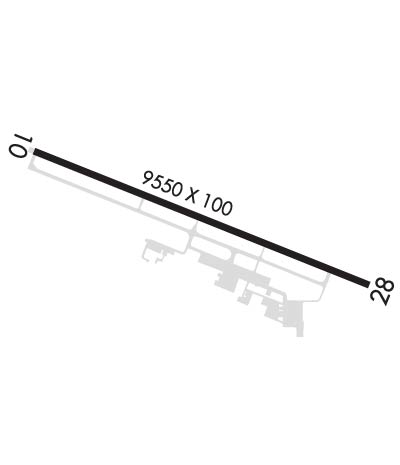
| Lat: N 3152.8 Long: W 10642.2 Elev: 4113 Var: -11 Longest Runway: 9550 | ||
| CTAF: 122.72 | ||
| ||||||
|
| Rwy | Rwy | |||||||
| 9550x100 | 9550' | 9550x100 | 9550' | |||||
| Runway ID | Single Wheel | Double Wheel | Double Tandem Wheel | Dual Double Wheel |
| 10/28 | 20,000 | N/A | N/A | N/A |
| These numbers are Advisory and are not limits. The Airport Manager should have more accurate Weight Limits | ||||
 Airport Diagram might not be current. | |
| Facility Name: | DONA ANA COUNTY AIRPORT AT SANTA TERESA |
| City Name: | SANTA TERESA |
| County: | DONA ANA |
| State abbrev: | NM |
| State Name: | NEW MEXICO |
| Ownership: | PUBLICLY OWNED |
| Use: | OPEN TO THE PUBLIC |
| Owner's Name: | DONA ANA COUNTY |
| Address: | 845 N. MOTEL |
| LAS CRUCES, NM 88007 | |
| Owner's Phone: | 575-647-7200 |
| Manager's Name: | BILL PROVANCE |
| Address: | 8014 AIRPORT RD. |
| SANTA TERESA, NM 88008 | |
| Phone: | 575-589-1232; EMERGENCY PHONE: 575-644-2358. |
| FAA Region: | SOUTHWEST |
| FAA Field Office: | LNM |
| Date | Sunrise | Sunset |
|---|---|---|
| 06/17/17 Saturday | 6:01 | 20:15 |
| 06/18/17 Sunday | 6:01 | 20:15 |
| 06/19/17 Monday | 6:01 | 20:15 |
| 06/20/17 Tuesday | 6:01 | 20:15 |
| 06/21/17 Wednesday | 6:01 | 20:16 |
| 06/22/17 Thursday | 6:02 | 20:16 |
| 06/23/17 Friday | 6:02 | 20:16 |
| 06/24/17 Saturday | 6:02 | 20:16 |
| 06/25/17 Sunday | 6:02 | 20:16 |
| 06/26/17 Monday | 6:03 | 20:16 |
| 06/27/17 Tuesday | 6:03 | 20:16 |
| 06/28/17 Wednesday | 6:03 | 20:17 |
| 06/29/17 Thursday | 6:04 | 20:17 |
| 06/30/17 Friday | 6:04 | 20:17 |
| Airport Attendance Schedule | 7 Days A Week 0700-2000 |
| Airport Status | OPERATIONAL (This Status can change at any time - please check NOTAMS) |
| Airport Lighting Schedule | ACTIVATE MIRL RY 10/28 -122.725 - 5 CLICKS. |
| Airport Storage Available | Tie Downs, Hanger |
| Extra Services Available | Charter, Flight Instruction, Parachute Jumping, Aircraft Rental |
| Wind Indicator | YES - (lighted) |
| Control Tower | NO |
| CTAF Frequency | 122.725 |
| Unicom Frequency | 122.725; AUTOMATED UNICOM 122.725 - 3 CLICKS. |
| Rotating Beacon Color | CLEAR-GREEN (Light Land Airport) |
| Segmented Circle | YES |
| Landing Fee |
| Airport Inspected | STATE - performed by PRIVATE CONTRACT PERSONNEL |
| Inspection Date | 04/06/2015 |
| Type of Fuel Available | Grade 100LL, JET A-1 (icing inhibitor, freeze point -50C); 24 HR. 100 LL SELF SERVICE AVAILABLE WITH MAJOR CREDIT CARD. |
| Airframe Repair Service | MAJOR |
| Power Plant Repair Service | MAJOR |
| Latitude | N3152.8 |
| Longitude | W10642.2 (ESTIMATED) |
| Arpt Elevation | 4112ft (SURVEYED) |
| Magnetic Variation | 11E |
| 4 miles NW | of SANTA TERESA |
| Traffic Pattern Altitude | |
| Sectional Chart | EL PASO |
| Operations (Reported) | Yearly | Avg. Daily |
|---|---|---|
| General Aviation Transient | 13000 | 36 |
| General Aviation Local | 27100 | 74 |
| Air Taxi | 200 | 1 |
| Commerical | 0 | 0 |
| Commuter | 0 | 0 |
| Military | 1200 | 3 |
| Aircraft based on Field | |
|---|---|
| General Aviation Singles | 102 |
| General Aviation Multi | 23 |
| Jet Aircraft | 18 |
| General Aviation Helicopters | 8 |
| Military Aircraft | 0 |
| Gliders | 0 |
| Ultralights | 0 |
| FSS on field | NO |
| FSS tie-in | ALBUQUERQUE |
| FSS Phone | 1-800-WX-BRIEF |
| Who issues Notams | ABQ |
| Notam D service at airport | YES |
| ARTCC Name | ALBUQUERQUE |
| Airport Certification | |
| Aircraft Rescue & Firefighting Index | None |
| Airport of Entry | YES; U.S. CUSTOM PORT OF ENTRY HOURS OF OPERATION 0800-2200 PHONE 915-730-7402. |
| Custom Landing Rights | YES; U.S. CUSTOMS USER FEE ARPT. |
| Joint Civil/Military | No |
| Military Landing rights | YES |
| NATIONAL PLAN OF INTEGRATED AIRPORT SYSTEMS (NPIAS) |
| GRANT AGREEMENTS UNDER FAAP/ADAP/AIP |
| CONVEYANCE UNDER SCETION 16, FEDERAL AIRPORT ACT OF 1946 OR SECTION 23, AIRPORT AND AIRWAY DEVELOPMENT ACT OF 1970 |
| ASSURANCES PURSUANT TO TITLE VI, CIVIL RIGHTS ACT OF 1964 |
Airport Communications & Frequencies:
|
| Runway: 10 | Runway: 28 | ||
| Mag heading: | 101° | Mag heading: | 281° |
| Rwy Slope: | -.02% Down | Rwy Slope: | .02% Up |
| Approach: | Approach: | ||
| Pattern: | Left Traffic | Pattern: | Right Traffic |
| Markings: | NONPRECISION INSTRUMENT | Markings: | NONPRECISION INSTRUMENT |
| Marking Condition: | GOOD | Marking Condition: | GOOD |
| Arresting Dev: | Arresting Dev: | ||
| Lat & Long: | N3153.1 W10643.1 | Lat. & Long.: | N3152.5 W10641.3 |
| Elev: | 4111.3 ft. MSL | Elev: | 4109.8 ft. MSL |
| TCH: | 43 ft. AGL | TCH: | 45 ft. AGL |
| Visual Glide Path: | 3.00 degrees | Visual Glide Path: | 3.00 degrees |
| Displaced Threshold: | No | Displaced Threshold: | No |
| Touchdown Zone: | YES | Touchdown Zone: | YES |
| Touchdown Elev.: | 4111.6 feet | Touchdown Elev.: | 4110.7 feet |
| Visual Glide Slope: | 2-Light PAPI on LEFT side of Runway | Visual Glide Slope: | 4-Light PAPI on LEFT side of Runway |
| RVR Equipment: | RVR Equipment: | ||
| RVV Equipment: | NO | RVV Equipment: | NO |
| Approach Lights: | Approach Lights: | ||
| REIL: | YES | REIL: | YES |
| Centerline Lights: | NO | Centerline Lights: | NO |
| Touchdown lights: | NO | Touchdown lights: | NO |
| Runway Category: | Runway with a Non-precision Approach having visibility minimums greater than 3/4 mile | Runway Category: | Runway with a Visual Approach |
| Declared Distances: | Declared Distances: | ||
| Obstructions: | RR | Obstructions: | |
| Marked: | NOT Marked/Lighted | Marked: | |
| Clearance slope: | 39:1 | Clearance slope: | 50:1 |
| Obstruction height: | 37 feet AGL | Obstruction height: | |
| Dist. from runway: | 1650 feet | Dist. from runway: | |
| Centerline offset: | 720 right of centerline | Centerline offset: | |
| Comments: | Comments: |
Thanks for using FltPlan.com
all rights reserved © 1999-2017 by Flight Plan LLC
