
| VALLEY VIEW ESTACADA OR |
| |
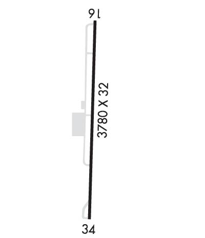
| Lat: N 4518.5 Long: W 12219.1 Elev: 735 Var: -19 Longest Runway: 3780 | ||
| CTAF: 122.9 | ||
| ||||||||||||||||||||||||||||||||
| ||||||||||||||||||||||||||||||||
| Rwy | Rwy | |||||||
| 3780x32 | 3290' | 3780x32 | 3780' | |||||
| Runway ID | Single Wheel | Double Wheel | Double Tandem Wheel | Dual Double Wheel |
| 16/34 | N/A | N/A | N/A | N/A |
| These numbers are Advisory and are not limits. The Airport Manager should have more accurate Weight Limits | ||||
| FltPlan does not have IFR approach charts available for K5S9. |
 Airport Diagram might not be current. | |
| Facility Name: | VALLEY VIEW |
| City Name: | ESTACADA |
| County: | CLACKAMAS |
| State abbrev: | OR |
| State Name: | OREGON |
| Ownership: | PRIVATELY OWNED |
| Use: | OPEN TO THE PUBLIC |
| Owner's Name: | 5 SIERRA 9, LLC - MICHAEL CZYZ |
| Address: | 4136 S. LAKE PARK AVENUE |
| CHICAGO, IL 60653 | |
| Owner's Phone: | 312-953-9055 |
| Manager's Name: | MICHAEL CZYZ |
| Address: | 4136 S. LAKE PARK AVENUE |
| CHICAGO, IL 60653 | |
| Phone: | 312-953-9055 |
| FAA Region: | NORTHWEST MOUNTAIN |
| FAA Field Office: | SEA |
| Date | Sunrise | Sunset |
|---|---|---|
| 09/24/21 Friday | 6:59 | 19:03 |
| 09/25/21 Saturday | 7:00 | 19:01 |
| 09/26/21 Sunday | 7:01 | 18:59 |
| 09/27/21 Monday | 7:02 | 18:57 |
| 09/28/21 Tuesday | 7:03 | 18:56 |
| 09/29/21 Wednesday | 7:05 | 18:54 |
| 09/30/21 Thursday | 7:06 | 18:52 |
| 10/01/21 Friday | 7:07 | 18:50 |
| 10/02/21 Saturday | 7:08 | 18:48 |
| 10/03/21 Sunday | 7:10 | 18:46 |
| 10/04/21 Monday | 7:11 | 18:44 |
| 10/05/21 Tuesday | 7:12 | 18:42 |
| 10/06/21 Wednesday | 7:14 | 18:40 |
| 10/07/21 Thursday | 7:15 | 18:39 |
| Airport Attendance Schedule | IRREGULAR |
| Airport Status | OPERATIONAL (This Status can change at any time - please check NOTAMS) |
| Airport Lighting Schedule | |
| Airport Storage Available | Tie Downs |
| Extra Services Available | NONE |
| Wind Indicator | YES - (unlit) |
| Control Tower | NO |
| CTAF Frequency | 122.900 |
| Unicom Frequency | |
| Rotating Beacon Color | |
| Segmented Circle | NO |
| Landing Fee | NO |
| Airport Inspected | STATE - performed by STATE AERONAUTICAL PERSONNEL |
| Inspection Date | 03/09/2021 |
| Type of Fuel Available | None |
| Airframe Repair Service | None |
| Power Plant Repair Service | None |
| Latitude | N4518.5 |
| Longitude | W12219.1 (ESTIMATED) |
| Arpt Elevation | 735ft (ESTIMATED) |
| Magnetic Variation | 19E |
| 1 miles NE | of ESTACADA |
| Traffic Pattern Altitude | 950 |
| Sectional Chart | SEATTLE |
| Operations (Reported) | Yearly | Avg. Daily |
|---|---|---|
| General Aviation Transient | 1830 | 5 |
| General Aviation Local | 1135 | 3 |
| Air Taxi | 0 | 0 |
| Commerical | 0 | 0 |
| Commuter | 0 | 0 |
| Military | 0 | 0 |
| Aircraft based on Field | |
|---|---|
| General Aviation Singles | 28 |
| General Aviation Multi | 4 |
| Jet Aircraft | 0 |
| General Aviation Helicopters | 1 |
| Military Aircraft | 0 |
| Gliders | 0 |
| Ultralights | 0 |
| FSS on field | NO |
| FSS tie-in | MC MINNVILLE |
| FSS Phone | 1-800-WX-BRIEF |
| Who issues Notams | MMV |
| Notam D service at airport | YES |
| ARTCC Name | SEATTLE |
| Airport Certification | |
| Aircraft Rescue & Firefighting Index | None |
| Airport of Entry | No |
| Custom Landing Rights | No |
| Joint Civil/Military | No |
| Military Landing rights | No |
| FOR CD CTC PORTLAND APCH AT 503-493-7545. |
| 15-45 FT TREES AT 20 FT E OF RWY FULL LEN. |
| Runway: 16 | Runway: 34 | ||
| Mag heading: | N/A | Mag heading: | N/A |
| Approach: | Approach: | ||
| Pattern: | Left Traffic | Pattern: | Left Traffic |
| Markings: | NUMBERS ONLY | Markings: | NUMBERS ONLY |
| Marking Condition: | GOOD | Marking Condition: | GOOD |
| Arresting Dev: | Arresting Dev: | ||
| Lat & Long: | Lat. & Long.: | ||
| Elev: | N/A | Elev: | N/A |
| TCH: | TCH: | ||
| Visual Glide Path: | Visual Glide Path: | ||
| Displaced Threshold: | 490 feet | Displaced Threshold: | No |
| Touchdown Zone: | NO | Touchdown Zone: | NO |
| Touchdown Elev.: | Touchdown Elev.: | ||
| Visual Glide Slope: | Visual Glide Slope: | ||
| RVR Equipment: | RVR Equipment: | ||
| RVV Equipment: | NO | RVV Equipment: | NO |
| Approach Lights: | Approach Lights: | ||
| REIL: | NO | REIL: | NO |
| Centerline Lights: | NO | Centerline Lights: | NO |
| Touchdown lights: | NO | Touchdown lights: | NO |
| Runway Category: | Runway with a Visual Approach | Runway Category: | Runway with a Visual Approach |
| Declared Distances: | Declared Distances: | ||
| Obstructions: | TREES | Obstructions: | TREES |
| Marked: | NOT Marked/Lighted | Marked: | NOT Marked/Lighted |
| Clearance slope: | RWY 16 APCH SLP 6:1 BASED ON DTHR. | Clearance slope: | |
| Obstruction height: | 70 feet AGL | Obstruction height: | 70 feet AGL |
| Dist. from runway: | 201 feet | Dist. from runway: | 201 feet |
| Centerline offset: | Centerline offset: | 125 feet right of centerline | |
| Comments: | RWY 16 75 FT TREES AT 10-200 FT FM RWY END, 60-100 FT LEFT & RIGHT OF CNTRLN. PVT RD ACES THE ARPT THRU SAFTEY AREA AND RPZ. | Comments: | 40-60 FT TREES AT 150-200 FT FM RWY END AND 75-85 FT LEFT OF CNTRLN. |
Thanks for using FltPlan.com
all rights reserved © 1999-2021 by Flight Plan LLC
