
| FOLEY MUNI FOLEY AL |
| |
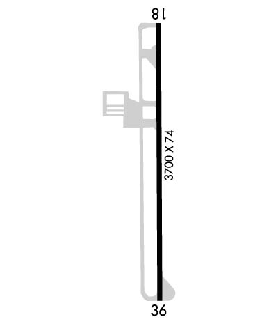
| Lat: N 3025.7 Long: W 08742.1 Elev: 74 Var: +02 Longest Runway: 3700 | ||
| CTAF: 123.05 | ||
| ||||||||||||||||||||||||||||||||
| ||||||||||||||||||||||||||||||||
| Rwy | Rwy | |||||||
| 3700x74 | 3700' | 3700x74 | 3513' | |||||
| Runway ID | Single Wheel | Double Wheel | Double Tandem Wheel | Dual Double Wheel |
| 18/36 | 28,000 | N/A | N/A | N/A |
| These numbers are Advisory and are not limits. The Airport Manager should have more accurate Weight Limits | ||||
 Airport Diagram might not be current. | |
| Facility Name: | FOLEY MUNI |
| City Name: | FOLEY |
| County: | BALDWIN |
| State abbrev: | AL |
| State Name: | ALABAMA |
| Ownership: | PUBLICLY OWNED |
| Use: | OPEN TO THE PUBLIC |
| Owner's Name: | CITY OF FOLEY |
| Address: | PO DRAWER 400 |
| FOLEY, AL 36536 | |
| Owner's Phone: | 251-943-1545 |
| Manager's Name: | RACHEL KEITH |
| Address: | 510 NORTH AIRPORT ROAD |
| FOLEY, AL 36535 | |
| Phone: | 251-943-1545 |
| FAA Region: | SOUTHERN |
| FAA Field Office: | JAN |
| Date | Sunrise | Sunset |
|---|---|---|
| 09/24/21 Friday | 6:40 | 18:45 |
| 09/25/21 Saturday | 6:41 | 18:44 |
| 09/26/21 Sunday | 6:41 | 18:43 |
| 09/27/21 Monday | 6:42 | 18:41 |
| 09/28/21 Tuesday | 6:42 | 18:40 |
| 09/29/21 Wednesday | 6:43 | 18:39 |
| 09/30/21 Thursday | 6:44 | 18:38 |
| 10/01/21 Friday | 6:44 | 18:36 |
| 10/02/21 Saturday | 6:45 | 18:35 |
| 10/03/21 Sunday | 6:45 | 18:34 |
| 10/04/21 Monday | 6:46 | 18:33 |
| 10/05/21 Tuesday | 6:47 | 18:32 |
| 10/06/21 Wednesday | 6:47 | 18:30 |
| 10/07/21 Thursday | 6:48 | 18:29 |
| Airport Attendance Schedule | 7 Days A Week 0800-1700 |
| Airport Status | OPERATIONAL (This Status can change at any time - please check NOTAMS) |
| Airport Lighting Schedule | ACTVT PAPI RWY 18 & 36; MIRL RWY 18/36 - CTAF. MIRL RWY 18/36 PRESET LOW INTST; INCR INTST - CTAF. |
| Airport Storage Available | Tie Downs |
| Extra Services Available | NONE |
| Wind Indicator | YES - (lighted) |
| Control Tower | NO |
| CTAF Frequency | 123.050 |
| Unicom Frequency | 123.050 |
| Rotating Beacon Color | CLEAR-GREEN (Light Land Airport) |
| Segmented Circle | YES |
| Landing Fee | NO |
| Airport Inspected | STATE - performed by STATE AERONAUTICAL PERSONNEL |
| Inspection Date | 12/19/2019 |
| Type of Fuel Available | Grade 100LL; -10FULL SVC AVGAS DURG NML HRS ONLY. |
| Airframe Repair Service | MAJOR |
| Power Plant Repair Service | NONE |
| Latitude | N3025.7 |
| Longitude | W08742.1 (ESTIMATED) |
| Arpt Elevation | 74ft (SURVEYED) |
| Magnetic Variation | 02W |
| 3 miles NW | of FOLEY |
| Traffic Pattern Altitude | |
| Sectional Chart | NEW ORLEANS |
| Operations (Reported) | Yearly | Avg. Daily |
|---|---|---|
| General Aviation Transient | 16500 | 45 |
| General Aviation Local | 8200 | 22 |
| Air Taxi | 0 | 0 |
| Commerical | 0 | 0 |
| Commuter | 0 | 0 |
| Military | 0 | 0 |
| Aircraft based on Field | |
|---|---|
| General Aviation Singles | 25 |
| General Aviation Multi | 2 |
| Jet Aircraft | 0 |
| General Aviation Helicopters | 0 |
| Military Aircraft | 0 |
| Gliders | 0 |
| Ultralights | 0 |
| FSS on field | NO |
| FSS tie-in | ANNISTON |
| FSS Phone | 1-800-WX-BRIEF |
| Who issues Notams | ANB |
| Notam D service at airport | YES |
| ARTCC Name | JACKSONVILLE |
| Airport Certification | |
| Aircraft Rescue & Firefighting Index | None |
| Airport of Entry | No |
| Custom Landing Rights | No |
| Joint Civil/Military | No |
| Military Landing rights | YES |
| NATIONAL PLAN OF INTEGRATED AIRPORT SYSTEMS (NPIAS) |
| GRANT AGREEMENTS UNDER FAAP/ADAP/AIP |
| ASSURANCES PURSUANT TO TITLE VI, CIVIL RIGHTS ACT OF 1964 |
| EXTSV STUDENT TRNG. |
| CIRCLING APCH NA EAST OF RWY. VOLUNTARY NOISE ABATEMENT PROC IN EFCT MON-SUN NGT TIME. VOLUNTARY RSTRS ON TOUCH AND GO, STOP AND GO, OR HEL OPS MON-SUN NGT TIME. RWY 18 NGT TIME PREFERENTIAL USE RWY FOR ALL ACFT DEP WHEN WINDS PERMIT. |
| LTD PRKG ON NORTH RAMP. TSNT ACFT URGED TO BRING TIE-DOWN ROPES FOR SOUTH RAMP PKNG. NO RAMP FEES EXCP ACFT OVER NGT PRKG. |
| FOR CD CTC PENSACOLA APCH AT 850-266-6884 OR 850-266-6885. |
Airport Communications & Frequencies:
| ||||||||||||||||
| Runway: 18 | Runway: 36 | ||
| Mag heading: | 182° | Mag heading: | 2° |
| Rwy Slope: | .31% Up | Rwy Slope: | -.31% Down |
| Approach: | Approach: | ||
| Pattern: | Right Traffic | Pattern: | Left Traffic |
| Markings: | NONPRECISION INSTRUMENT | Markings: | NONPRECISION INSTRUMENT |
| Marking Condition: | POOR; MARKINGS FADED. | Marking Condition: | POOR; MARKINGS FADED. |
| Arresting Dev: | Arresting Dev: | ||
| Lat & Long: | N3026.0 W08742.1 | Lat. & Long.: | N3025.4 W08742.1 |
| Elev: | 62.7 ft. MSL | Elev: | 74.3 ft. MSL |
| TCH: | 40 ft. AGL | TCH: | 38 ft. AGL |
| Visual Glide Path: | 3.00 degrees | Visual Glide Path: | 3.00 degrees |
| Displaced Threshold: | No | Displaced Threshold: | 187 feet |
| Touchdown Zone: | YES | Touchdown Zone: | YES |
| Touchdown Elev.: | 72.3 feet | Touchdown Elev.: | 72.6 feet |
| Visual Glide Slope: | 2-Light PAPI on LEFT side of Runway | Visual Glide Slope: | 2-Light PAPI on LEFT side of Runway; PAPI UNUSBL BYD 6 DEG LEFT OF CNTRLN. |
| RVR Equipment: | RVR Equipment: | ||
| RVV Equipment: | NO | RVV Equipment: | NO |
| Approach Lights: | Approach Lights: | ||
| REIL: | NO | REIL: | NO |
| Centerline Lights: | NO | Centerline Lights: | NO |
| Touchdown lights: | NO | Touchdown lights: | NO |
| Runway Category: | Runway with a Non-precision Approach | Runway Category: | Runway with a Non-precision Approach |
| Declared Distances: | Declared Distances: | ||
| Obstructions: | Obstructions: | ROAD | |
| Marked: | Marked: | NOT Marked/Lighted | |
| Clearance slope: | 50:1 | Clearance slope: | 18:1 |
| Obstruction height: | Obstruction height: | 14 feet AGL | |
| Dist. from runway: | Dist. from runway: | 453 feet | |
| Centerline offset: | Centerline offset: | ||
| Comments: | Comments: |
Thanks for using FltPlan.com
all rights reserved © 1999-2021 by Flight Plan LLC
