
| PRENTICE PRENTICE WI |
| |
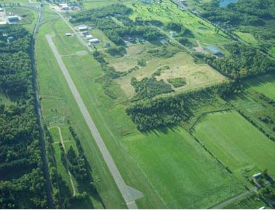
| Lat: N 4532.3 Long: W 09016.6 Elev: 1579 Var: -00 Longest Runway: 3134 | ||
| CTAF: 123.0 | ||
| ||||||||||||||||||||||||||||||||
| ||||||||||||||||||||||||||||||||
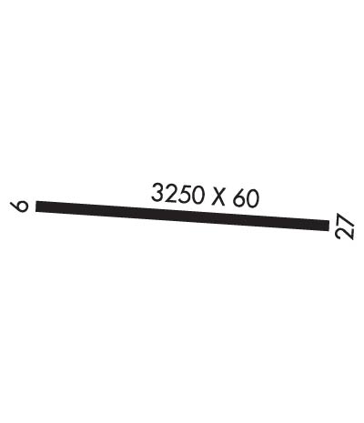
| Rwy | Rwy | |||||||
| 3134x60 | 2797' | 3134x60 | 3134' | |||||
| Runway ID | Single Wheel | Double Wheel | Double Tandem Wheel | Dual Double Wheel |
| 09/27 | N/A | N/A | N/A | N/A |
| These numbers are Advisory and are not limits. The Airport Manager should have more accurate Weight Limits | ||||
| FltPlan does not have IFR approach charts available for K5N2. |
 Airport Diagram might not be current. | |
| Facility Name: | PRENTICE |
| City Name: | PRENTICE |
| County: | PRICE |
| State abbrev: | WI |
| State Name: | WISCONSIN |
| Ownership: | PUBLICLY OWNED |
| Use: | OPEN TO THE PUBLIC |
| Owner's Name: | VILLAGE OF PRENTICE |
| Address: | 403 CENTER ST |
| PRENTICE, WI 54556 | |
| Owner's Phone: | 715-428-2124 |
| Manager's Name: | DALE HEIKKINEN |
| Address: | PO BOX 108 |
| PRENTICE, WI 54556 | |
| Phone: | 715-360-2000 |
| FAA Region: | GREAT LAKES |
| FAA Field Office: | CHI |
| Date | Sunrise | Sunset |
|---|---|---|
| 06/08/26 Monday | 5:13 | 20:48 |
| 06/09/26 Tuesday | 5:12 | 20:48 |
| 06/10/26 Wednesday | 5:12 | 20:49 |
| 06/11/26 Thursday | 5:12 | 20:50 |
| 06/12/26 Friday | 5:12 | 20:50 |
| 06/13/26 Saturday | 5:12 | 20:51 |
| 06/14/26 Sunday | 5:12 | 20:51 |
| 06/15/26 Monday | 5:12 | 20:52 |
| 06/16/26 Tuesday | 5:12 | 20:52 |
| 06/17/26 Wednesday | 5:12 | 20:52 |
| 06/18/26 Thursday | 5:12 | 20:53 |
| 06/19/26 Friday | 5:12 | 20:53 |
| 06/20/26 Saturday | 5:12 | 20:53 |
| 06/21/26 Sunday | 5:12 | 20:54 |
| Airport Attendance Schedule | UNATTENDED |
| Airport Status | OPERATIONAL (This Status can change at any time - please check NOTAMS) |
| Airport Lighting Schedule | ACTVT MIRL RY 09/27 & TWY LGTS - CTAF. |
| Airport Storage Available | Tie Downs |
| Extra Services Available | NONE |
| Wind Indicator | YES - (lighted) |
| Control Tower | NO |
| CTAF Frequency | 123.000 |
| Unicom Frequency | 123.000 |
| Rotating Beacon Color | WG |
| Segmented Circle | YES |
| Landing Fee | NO |
| Airport Inspected | STATE - performed by STATE AERONAUTICAL PERSONNEL |
| Inspection Date | 06/22/2023 |
| Type of Fuel Available | None |
| Airframe Repair Service | NONE |
| Power Plant Repair Service | NONE |
| Latitude | N4532.3 |
| Longitude | W09016.6 (ESTIMATED) |
| Arpt Elevation | 1578ft (SURVEYED) |
| Magnetic Variation | 00E |
| 1 miles E | of PRENTICE |
| Traffic Pattern Altitude | |
| Sectional Chart | GREEN BAY |
| Operations (Reported) | Yearly | Avg. Daily |
|---|---|---|
| General Aviation Transient | 0 | 0 |
| General Aviation Local | 0 | 0 |
| Air Taxi | 0 | 0 |
| Commerical | 0 | 0 |
| Commuter | 0 | 0 |
| Military | 0 | 0 |
| Aircraft based on Field | |
|---|---|
| General Aviation Singles | 0 |
| General Aviation Multi | 0 |
| Jet Aircraft | 0 |
| General Aviation Helicopters | 0 |
| Military Aircraft | 0 |
| Gliders | 0 |
| Ultralights | 0 |
| FSS on field | NO |
| FSS tie-in | GREEN BAY |
| FSS Phone | 1-800-WX-BRIEF |
| Who issues Notams | GRB |
| Notam D service at airport | YES |
| ARTCC Name | MINNEAPOLIS |
| Airport Certification | |
| Aircraft Rescue & Firefighting Index | None |
| Airport of Entry | No |
| Custom Landing Rights | No |
| Joint Civil/Military | No |
| Military Landing rights | No |
| FOR CD CTC MINNEAPOLIS ARTCC AT 651-463-5588. |
| Runway: 09 | Runway: 27 | ||
| Mag heading: | N/A | Mag heading: | N/A |
| Rwy Slope: | .68% Up | Rwy Slope: | -.68% Down |
| Approach: | Approach: | ||
| Pattern: | Left Traffic | Pattern: | Left Traffic |
| Markings: | BASIC | Markings: | BASIC |
| Marking Condition: | FAIR | Marking Condition: | FAIR |
| Arresting Dev: | Arresting Dev: | ||
| Lat & Long: | N4532.3 W09016.9 | Lat. & Long.: | N4532.3 W09016.2 |
| Elev: | 1557.1 ft. MSL | Elev: | 1578.5 ft. MSL |
| TCH: | TCH: | ||
| Visual Glide Path: | Visual Glide Path: | ||
| Displaced Threshold: | 337 feet | Displaced Threshold: | No |
| Touchdown Zone: | NO | Touchdown Zone: | NO |
| Touchdown Elev.: | Touchdown Elev.: | ||
| Visual Glide Slope: | Visual Glide Slope: | ||
| RVR Equipment: | RVR Equipment: | ||
| RVV Equipment: | NO | RVV Equipment: | NO |
| Approach Lights: | Approach Lights: | ||
| REIL: | NO | REIL: | NO |
| Centerline Lights: | NO | Centerline Lights: | NO |
| Touchdown lights: | NO | Touchdown lights: | NO |
| Runway Category: | Runway with a Visual Approach | Runway Category: | Runway with a Visual Approach |
| Declared Distances: | Declared Distances: | ||
| Obstructions: | RR | Obstructions: | ROAD |
| Marked: | NOT Marked/Lighted | Marked: | NOT Marked/Lighted |
| Clearance slope: | APCH RATIO 20:1 TO DSPLCD THR. | Clearance slope: | 11:1 |
| Obstruction height: | 23 feet AGL | Obstruction height: | 8 feet AGL |
| Dist. from runway: | 200 feet | Dist. from runway: | 285 feet |
| Centerline offset: | 125 right of centerline | Centerline offset: | |
| Comments: | RR 200 FT FM RWY END; 125 FT R; 5 FT SIGN 190 FT FM RWY END; 63 FT L. | Comments: |
Thanks for using FltPlan.com
all rights reserved © 1999-2026 by Flight Plan LLC