| MARION-CRITTENDEN COUNTY MARION KY |
| |
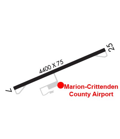
| Lat: N 3720.2 Long: W 08806.6 Elev: 650 Var: +02 Longest Runway: 4400 | ||
| AWOS: 118.15 CTAF: 122.9 | ||
| |||||||||||||||||||||||
| |||||||||||||||||||||||
| |||||||||||||||||||||||
| Rwy | Rwy | |||||||
| 4400x75 | 4400' | 4400x75 | 4400' | |||||
| Runway ID | Single Wheel | Double Wheel | Double Tandem Wheel | Dual Double Wheel |
| 07/25 | N/A | N/A | N/A | N/A |
| These numbers are Advisory and are not limits. The Airport Manager should have more accurate Weight Limits | ||||
 Airport Diagram might not be current. | |
| Facility Name: | MARION-CRITTENDEN COUNTY JAMES C JOHNSON RGNL |
| City Name: | MARION |
| County: | CRITTENDEN |
| State abbrev: | KY |
| State Name: | KENTUCKY |
| Ownership: | PUBLICLY OWNED |
| Use: | OPEN TO THE PUBLIC |
| Owner's Name: | MARION-CRITTENDEN CITY APT BOARD |
| Address: | 500 AIRPORT RD |
| MARION, KY 42064 | |
| Owner's Phone: | 270-965-4242 |
| Manager's Name: | JIM JOHNSON |
| Address: | 500 AIRPORT ROAD |
| MARION, KY 42064 | |
| Phone: | 270-965-4242 |
| FAA Region: | SOUTHERN |
| FAA Field Office: | MEM |
| Date | Sunrise | Sunset |
|---|---|---|
| 09/24/21 Friday | 6:42 | 18:47 |
| 09/25/21 Saturday | 6:43 | 18:45 |
| 09/26/21 Sunday | 6:43 | 18:44 |
| 09/27/21 Monday | 6:44 | 18:42 |
| 09/28/21 Tuesday | 6:45 | 18:41 |
| 09/29/21 Wednesday | 6:46 | 18:39 |
| 09/30/21 Thursday | 6:47 | 18:37 |
| 10/01/21 Friday | 6:48 | 18:36 |
| 10/02/21 Saturday | 6:49 | 18:34 |
| 10/03/21 Sunday | 6:49 | 18:33 |
| 10/04/21 Monday | 6:50 | 18:31 |
| 10/05/21 Tuesday | 6:51 | 18:30 |
| 10/06/21 Wednesday | 6:52 | 18:29 |
| 10/07/21 Thursday | 6:53 | 18:27 |
| Airport Attendance Schedule | UNATTENDED |
| Airport Status | OPERATIONAL (This Status can change at any time - please check NOTAMS) |
| Airport Lighting Schedule | ACTVT REIL RWY 7 & 25; PAPI RWY 7 & 25; MIRL RWY 07/25 - CTAF. |
| Airport Storage Available | Tie Downs, Hanger |
| Extra Services Available | Flight Instruction |
| Wind Indicator | YES - (unlit) |
| Control Tower | NO |
| CTAF Frequency | 122.900 |
| Unicom Frequency | |
| Rotating Beacon Color | CLEAR-GREEN (Light Land Airport) |
| Segmented Circle | YES |
| Landing Fee | NO |
| Airport Inspected | STATE - performed by STATE AERONAUTICAL PERSONNEL |
| Inspection Date | 10/18/2019 |
| Type of Fuel Available | Grade 100LL, JET A |
| Airframe Repair Service | NONE |
| Power Plant Repair Service | NONE |
| Latitude | N3720.2 |
| Longitude | W08806.6 (ESTIMATED) |
| Arpt Elevation | 649ft (SURVEYED) |
| Magnetic Variation | 02W |
| 1 miles SW | of MARION |
| Traffic Pattern Altitude | |
| Sectional Chart | ST LOUIS |
| Operations (Reported) | Yearly | Avg. Daily |
|---|---|---|
| General Aviation Transient | 1575 | 4 |
| General Aviation Local | 2625 | 7 |
| Air Taxi | 1050 | 3 |
| Commerical | 0 | 0 |
| Commuter | 0 | 0 |
| Military | 1050 | 3 |
| Aircraft based on Field | |
|---|---|
| General Aviation Singles | 22 |
| General Aviation Multi | 2 |
| Jet Aircraft | 0 |
| General Aviation Helicopters | 0 |
| Military Aircraft | 0 |
| Gliders | 0 |
| Ultralights | 0 |
| FSS on field | NO |
| FSS tie-in | LOUISVILLE |
| FSS Phone | 1-800-WX-BRIEF |
| Who issues Notams | LOU |
| Notam D service at airport | YES |
| ARTCC Name | MEMPHIS |
| Airport Certification | |
| Aircraft Rescue & Firefighting Index | None |
| Airport of Entry | No |
| Custom Landing Rights | No |
| Joint Civil/Military | No |
| Military Landing rights | No |
| NATIONAL PLAN OF INTEGRATED AIRPORT SYSTEMS (NPIAS) |
| RWY COND - AMGR. |
| CRITTENDEN CO HOSP HELI 1 NM SE. |
| FOR CD CTC MEMPHIS ARTCC AT 901-368-8453/8449. |
Airport Communications & Frequencies:
| |||||||
| Runway: 07 | Runway: 25 | ||
| Mag heading: | 68° | Mag heading: | 248° |
| Rwy Slope: | -.50% Down | Rwy Slope: | .50% Up |
| Approach: | Approach: | ||
| Pattern: | Left Traffic | Pattern: | Left Traffic |
| Markings: | NONPRECISION INSTRUMENT | Markings: | NONPRECISION INSTRUMENT |
| Marking Condition: | GOOD | Marking Condition: | GOOD |
| Arresting Dev: | Arresting Dev: | ||
| Lat & Long: | N3720.0 W08807.0 | Lat. & Long.: | N3720.3 W08806.2 |
| Elev: | 649.6 ft. MSL | Elev: | 627.8 ft. MSL |
| TCH: | 30 ft. AGL | TCH: | 36 ft. AGL |
| Visual Glide Path: | 3.00 degrees | Visual Glide Path: | 3.00 degrees |
| Displaced Threshold: | No | Displaced Threshold: | No |
| Touchdown Zone: | YES | Touchdown Zone: | YES |
| Touchdown Elev.: | 649.6 feet | Touchdown Elev.: | 643.1 feet |
| Visual Glide Slope: | 4-Light PAPI on LEFT side of Runway | Visual Glide Slope: | 4-Light PAPI on LEFT side of Runway |
| RVR Equipment: | RVR Equipment: | ||
| RVV Equipment: | NO | RVV Equipment: | NO |
| Approach Lights: | Approach Lights: | ||
| REIL: | YES | REIL: | YES |
| Centerline Lights: | NO | Centerline Lights: | NO |
| Touchdown lights: | NO | Touchdown lights: | NO |
| Runway Category: | Runway with a Non-precision Approach | Runway Category: | Runway with a Non-precision Approach |
| Declared Distances: | Declared Distances: | ||
| Obstructions: | TREES | Obstructions: | TREES |
| Marked: | NOT Marked/Lighted | Marked: | NOT Marked/Lighted |
| Clearance slope: | 10:1 | Clearance slope: | 1:1 |
| Obstruction height: | 25 feet AGL | Obstruction height: | 29 feet AGL |
| Dist. from runway: | 464 feet | Dist. from runway: | 215 feet |
| Centerline offset: | 278 left of centerline | Centerline offset: | 240 feet right of centerline |
| Comments: | Comments: |
Thanks for using FltPlan.com
all rights reserved © 1999-2021 by Flight Plan LLC