
| EAST TROY MUNI EAST TROY WI |
| |
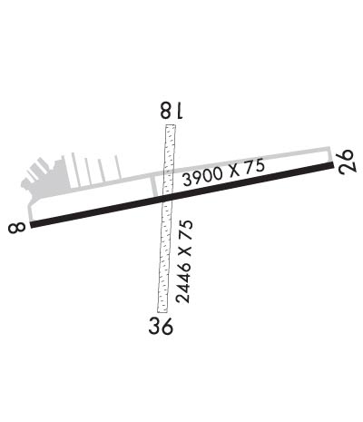
| Lat: N 4247.8 Long: W 08822.4 Elev: 860 Var: +02 Longest Runway: 3900 | ||
| CTAF: 123.0 | ||
| ||||||
|
| Rwy | Rwy | |||||||
| 3900x75 | 3900' | 3900x75 | 3900' | |||||
| 2446x75 | 2446' | 2446x75 | 2446' | |||||
| Runway ID | Single Wheel | Double Wheel | Double Tandem Wheel | Dual Double Wheel |
| 08/26 | 12,000 | N/A | N/A | N/A |
| 18/36 | N/A | N/A | N/A | N/A |
| These numbers are Advisory and are not limits. The Airport Manager should have more accurate Weight Limits | ||||
 Airport Diagram might not be current. | |
| Facility Name: | EAST TROY MUNI |
| City Name: | EAST TROY |
| County: | WALWORTH |
| State abbrev: | WI |
| State Name: | WISCONSIN |
| Ownership: | PUBLICLY OWNED |
| Use: | OPEN TO THE PUBLIC |
| Owner's Name: | VILLAGE OF EAST TROY |
| Address: | 2015 ENERGY DRIVE |
| EAST TROY, WI 53120 | |
| Owner's Phone: | 262-642-6255 |
| Manager's Name: | WALTER WATKINS; AVIATOR SVCS LLC |
| Address: | P O BOX 57 |
| FONTANA, WI 53125 | |
| Phone: | 262-215-2949 |
| FAA Region: | GREAT LAKES |
| FAA Field Office: | CHI |
| Date | Sunrise | Sunset |
|---|---|---|
| 09/24/21 Friday | 6:43 | 18:48 |
| 09/25/21 Saturday | 6:44 | 18:46 |
| 09/26/21 Sunday | 6:45 | 18:44 |
| 09/27/21 Monday | 6:46 | 18:42 |
| 09/28/21 Tuesday | 6:47 | 18:40 |
| 09/29/21 Wednesday | 6:48 | 18:39 |
| 09/30/21 Thursday | 6:49 | 18:37 |
| 10/01/21 Friday | 6:50 | 18:35 |
| 10/02/21 Saturday | 6:52 | 18:33 |
| 10/03/21 Sunday | 6:53 | 18:32 |
| 10/04/21 Monday | 6:54 | 18:30 |
| 10/05/21 Tuesday | 6:55 | 18:28 |
| 10/06/21 Wednesday | 6:56 | 18:26 |
| 10/07/21 Thursday | 6:57 | 18:25 |
| Airport Attendance Schedule | 7 Days A Week IREG |
| Airport Status | OPERATIONAL (This Status can change at any time - please check NOTAMS) |
| Airport Lighting Schedule | MIRL RY 08/26 IS PRESET ON LOW INTST; TO INCR INTST & ACTVT REIL RYS 08/26; PAPI RY 08 & RY 26; MIRL 08/26 - CTAF. |
| Airport Storage Available | Tie Downs, Hanger |
| Extra Services Available | Flight Instruction, Parachute Jumping, Aircraft Rental |
| Wind Indicator | YES - (unlit) |
| Control Tower | NO |
| CTAF Frequency | 123.000 |
| Unicom Frequency | 123.000 |
| Rotating Beacon Color | CLEAR-GREEN (Light Land Airport) |
| Segmented Circle | NO |
| Landing Fee | NO |
| Airport Inspected | STATE - performed by STATE AERONAUTICAL PERSONNEL |
| Inspection Date | 05/05/2021 |
| Type of Fuel Available | Grade 100LL, JET A (freeze point -40C)UL94 |
| Airframe Repair Service | MAJOR |
| Power Plant Repair Service | MAJOR |
| Latitude | N4247.8 |
| Longitude | W08822.4 (ESTIMATED) |
| Arpt Elevation | 860ft (SURVEYED) |
| Magnetic Variation | 02W |
| 2 miles NE | of EAST TROY |
| Traffic Pattern Altitude | |
| Sectional Chart | CHICAGO |
| Operations (Reported) | Yearly | Avg. Daily |
|---|---|---|
| General Aviation Transient | 20000 | 55 |
| General Aviation Local | 20000 | 55 |
| Air Taxi | 800 | 2 |
| Commerical | 0 | 0 |
| Commuter | 0 | 0 |
| Military | 200 | 1 |
| Aircraft based on Field | |
|---|---|
| General Aviation Singles | 52 |
| General Aviation Multi | 3 |
| Jet Aircraft | 1 |
| General Aviation Helicopters | 6 |
| Military Aircraft | 0 |
| Gliders | 0 |
| Ultralights | 0 |
| FSS on field | NO |
| FSS tie-in | GREEN BAY |
| FSS Phone | 1-800-WX-BRIEF |
| Who issues Notams | GRB |
| Notam D service at airport | YES |
| ARTCC Name | CHICAGO |
| Airport Certification | |
| Aircraft Rescue & Firefighting Index | None |
| Airport of Entry | No |
| Custom Landing Rights | No |
| Joint Civil/Military | No |
| Military Landing rights | No |
| NATIONAL PLAN OF INTEGRATED AIRPORT SYSTEMS (NPIAS) |
| GRANT AGREEMENTS UNDER FAAP/ADAP/AIP |
| ASSURANCES PURSUANT TO TITLE VI, CIVIL RIGHTS ACT OF 1964 |
| ULTRALIGHTS & LSA TRAINING ON & INVOF ARPT. |
| NOISE ABATEMENT PROCS IN EFCT. TFC DEPARTING RWY 26 AVOID OVERFLIGHT OF RESIDENTIAL AREA WEST OF FREEWAY. |
| FOR CD CTC MILWAUKEE APCH ON GCO FREQ 121.725. FOR CD WHEN GCO UNA CTC CHICAGO ARTCC AT 630-856-4562. |
| RWY 18/3 6 BE ALERT: RY 18/36 NOT PLOWED 15 OCT - 15 MAY. |
| RWY 08/2 6 SLOPES UP APRXLY 20 FT FM WEST TO EAST. |
Airport Communications & Frequencies:
| ||||||||||||||
| Runway: 08 | Runway: 26 | ||
| Mag heading: | 81° | Mag heading: | 261° |
| Rwy Slope: | .45% Up | Rwy Slope: | -.45% Down |
| Approach: | Approach: | ||
| Pattern: | Left Traffic | Pattern: | Left Traffic |
| Markings: | NONPRECISION INSTRUMENT | Markings: | NONPRECISION INSTRUMENT |
| Marking Condition: | FAIR | Marking Condition: | FAIR |
| Arresting Dev: | Arresting Dev: | ||
| Lat & Long: | N4247.8 W08822.8 | Lat. & Long.: | N4247.9 W08821.9 |
| Elev: | 842.7 ft. MSL | Elev: | 860.2 ft. MSL |
| TCH: | 44 ft. AGL | TCH: | 40 ft. AGL |
| Visual Glide Path: | 3.00 degrees | Visual Glide Path: | 3.00 degrees |
| Displaced Threshold: | No | Displaced Threshold: | No |
| Touchdown Zone: | YES | Touchdown Zone: | YES |
| Touchdown Elev.: | 851.0 feet | Touchdown Elev.: | 860.2 feet |
| Visual Glide Slope: | 2-Light PAPI on LEFT side of Runway | Visual Glide Slope: | 2-Light PAPI on LEFT side of Runway |
| RVR Equipment: | RVR Equipment: | ||
| RVV Equipment: | NO | RVV Equipment: | NO |
| Approach Lights: | Approach Lights: | ||
| REIL: | YES | REIL: | YES |
| Centerline Lights: | NO | Centerline Lights: | NO |
| Touchdown lights: | NO | Touchdown lights: | NO |
| Runway Category: | Runway with a Non-precision Approach | Runway Category: | Runway with a Non-precision Approach |
| Declared Distances: | Declared Distances: | ||
| Obstructions: | Obstructions: | TREES | |
| Marked: | Marked: | NOT Marked/Lighted | |
| Clearance slope: | 20:1 | Clearance slope: | 8:1 |
| Obstruction height: | Obstruction height: | 35 feet AGL | |
| Dist. from runway: | Dist. from runway: | 480 feet | |
| Centerline offset: | Centerline offset: | 290 feet right of centerline | |
| Comments: | Comments: |
| Runway: 18 | Runway: 36 | ||
| Mag heading: | 185° | Mag heading: | 5° |
| Rwy Slope: | -.42% Down | Rwy Slope: | .42% Up |
| Approach: | Approach: | ||
| Pattern: | Left Traffic | Pattern: | Left Traffic |
| Markings: | Markings: | ||
| Marking Condition: | RWY 18/36 MKD WITH YELLOW CONES. | Marking Condition: | |
| Arresting Dev: | Arresting Dev: | ||
| Lat & Long: | N4248.0 W08822.4 | Lat. & Long.: | N4247.6 W08822.4 |
| Elev: | 838.5 ft. MSL | Elev: | 828.2 ft. MSL |
| TCH: | TCH: | ||
| Visual Glide Path: | Visual Glide Path: | ||
| Displaced Threshold: | No | Displaced Threshold: | No |
| Touchdown Zone: | YES | Touchdown Zone: | YES |
| Touchdown Elev.: | 838.5 feet | Touchdown Elev.: | 838.5 feet |
| Visual Glide Slope: | Visual Glide Slope: | ||
| RVR Equipment: | RVR Equipment: | ||
| RVV Equipment: | NO | RVV Equipment: | NO |
| Approach Lights: | Approach Lights: | ||
| REIL: | NO | REIL: | NO |
| Centerline Lights: | NO | Centerline Lights: | NO |
| Touchdown lights: | NO | Touchdown lights: | NO |
| Runway Category: | Runway with a Visual Approach | Runway Category: | Runway with a Visual Approach |
| Declared Distances: | Declared Distances: |
Thanks for using FltPlan.com
all rights reserved © 1999-2021 by Flight Plan LLC
