
| MADISON MUNI MADISON GA |
| |
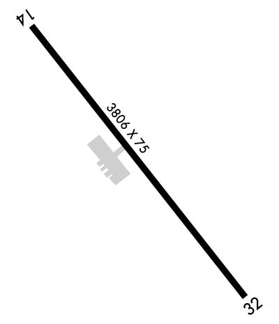
| Lat: N 3336.7 Long: W 08327.6 Elev: 694 Var: +04 Longest Runway: 3806 | ||
| CTAF: 122.8 | ||
| ||||||||||||||||||||||||||||||||||||||||||||
| ||||||||||||||||||||||||||||||||||||||||||||
| Rwy | Rwy | |||||||
| 3806x75 | 3806' | 3806x75 | 2675' | |||||
| Runway ID | Single Wheel | Double Wheel | Double Tandem Wheel | Dual Double Wheel |
| 14/32 | 20,000 | N/A | N/A | N/A |
| These numbers are Advisory and are not limits. The Airport Manager should have more accurate Weight Limits | ||||
 Airport Diagram might not be current. | |
| Facility Name: | MADISON MUNI |
| City Name: | MADISON |
| County: | MORGAN |
| State abbrev: | GA |
| State Name: | GEORGIA |
| Ownership: | PUBLICLY OWNED |
| Use: | OPEN TO THE PUBLIC |
| Owner's Name: | CITY OF MADISON |
| Address: | 132 NORTH MAIN STREET |
| MADISON, GA 30650 | |
| Owner's Phone: | 706-342-1251 |
| Manager's Name: | JOHN KLIMM; CITY MGR |
| Address: | 132 NORTH MAIN STREET |
| MADISON, GA 30650 | |
| Phone: | 706-342-1251; ARPT PHONE 706-342-9857 |
| FAA Region: | SOUTHERN |
| FAA Field Office: | ATL |
| Date | Sunrise | Sunset |
|---|---|---|
| 06/08/26 Monday | 6:23 | 20:43 |
| 06/09/26 Tuesday | 6:23 | 20:43 |
| 06/10/26 Wednesday | 6:23 | 20:44 |
| 06/11/26 Thursday | 6:23 | 20:44 |
| 06/12/26 Friday | 6:23 | 20:44 |
| 06/13/26 Saturday | 6:23 | 20:45 |
| 06/14/26 Sunday | 6:23 | 20:45 |
| 06/15/26 Monday | 6:23 | 20:46 |
| 06/16/26 Tuesday | 6:23 | 20:46 |
| 06/17/26 Wednesday | 6:23 | 20:46 |
| 06/18/26 Thursday | 6:23 | 20:46 |
| 06/19/26 Friday | 6:24 | 20:47 |
| 06/20/26 Saturday | 6:24 | 20:47 |
| 06/21/26 Sunday | 6:24 | 20:47 |
| Airport Attendance Schedule | MON-SAT 0900-1500, SUN 0900 - 1200 |
| Airport Status | OPERATIONAL (This Status can change at any time - please check NOTAMS) |
| Airport Lighting Schedule | ACTVT MIRL RY 14/32 & PAPI RY 14 - CTAF. |
| Airport Storage Available | Tie Downs |
| Extra Services Available | NONE |
| Wind Indicator | YES - (lighted) |
| Control Tower | NO |
| CTAF Frequency | 122.800 |
| Unicom Frequency | 122.800 |
| Rotating Beacon Color | WG |
| Segmented Circle | YES |
| Landing Fee | NO |
| Airport Inspected | STATE - performed by STATE AERONAUTICAL PERSONNEL |
| Inspection Date | 03/28/2025 |
| Type of Fuel Available | Grade 100LL; -10SELF SVC FUEL AVBL 24 HRS WITH CREDIT CARD. |
| Airframe Repair Service | MINOR |
| Power Plant Repair Service | MINOR |
| Latitude | N3336.7 |
| Longitude | W08327.6 (ESTIMATED) |
| Arpt Elevation | 694ft (SURVEYED) |
| Magnetic Variation | 04W |
| 2 miles NE | of MADISON |
| Traffic Pattern Altitude | |
| Sectional Chart | ATLANTA |
| Operations (Reported) | Yearly | Avg. Daily |
|---|---|---|
| General Aviation Transient | 0 | 0 |
| General Aviation Local | 0 | 0 |
| Air Taxi | 0 | 0 |
| Commerical | 0 | 0 |
| Commuter | 0 | 0 |
| Military | 0 | 0 |
| Aircraft based on Field | |
|---|---|
| General Aviation Singles | 0 |
| General Aviation Multi | 0 |
| Jet Aircraft | 0 |
| General Aviation Helicopters | 0 |
| Military Aircraft | 0 |
| Gliders | 0 |
| Ultralights | 0 |
| FSS on field | NO |
| FSS tie-in | MACON |
| FSS Phone | 1-800-WX-BRIEF |
| Who issues Notams | MCN |
| Notam D service at airport | YES |
| ARTCC Name | ATLANTA |
| Airport Certification | |
| Aircraft Rescue & Firefighting Index | None |
| Airport of Entry | No |
| Custom Landing Rights | No |
| Joint Civil/Military | No |
| Military Landing rights | YES |
| NATIONAL PLAN OF INTEGRATED AIRPORT SYSTEMS (NPIAS) |
| GRANT AGREEMENTS UNDER FAAP/ADAP/AIP |
| ASSURANCES PURSUANT TO TITLE VI, CIVIL RIGHTS ACT OF 1964 |
| FOR CD CTC ATLANTA APCH AT 678-364-6131, WHEN APCH CLSD CTC ATLANTA ARTCC AT 770-210-7692. |
Airport Communications & Frequencies:
| |||||||||||||||||
| Runway: 14 | Runway: 32 | ||
| Mag heading: | 145° | Mag heading: | 325° |
| Rwy Slope: | 1.52% Up | Rwy Slope: | -1.52% Down |
| Approach: | Approach: | ||
| Pattern: | Left Traffic | Pattern: | Right Traffic |
| Markings: | NONPRECISION INSTRUMENT | Markings: | NONPRECISION INSTRUMENT |
| Marking Condition: | GOOD | Marking Condition: | GOOD |
| Arresting Dev: | Arresting Dev: | ||
| Lat & Long: | N3337.0 W08327.9 | Lat. & Long.: | N3336.5 W08327.4 |
| Elev: | 636.3 ft. MSL | Elev: | 694.0 ft. MSL |
| TCH: | 32 ft. AGL | TCH: | |
| Visual Glide Path: | 3.00 degrees | Visual Glide Path: | |
| Displaced Threshold: | No | Displaced Threshold: | 1131 feet |
| Touchdown Zone: | YES | Touchdown Zone: | YES |
| Touchdown Elev.: | 686.0 feet | Touchdown Elev.: | 694.0 feet |
| Visual Glide Slope: | 2-Light PAPI on LEFT side of Runway | Visual Glide Slope: | |
| RVR Equipment: | RVR Equipment: | ||
| RVV Equipment: | NO | RVV Equipment: | NO |
| Approach Lights: | Approach Lights: | ||
| REIL: | NO | REIL: | NO |
| Centerline Lights: | NO | Centerline Lights: | NO |
| Touchdown lights: | NO | Touchdown lights: | NO |
| Runway Category: | Runway with a Non-precision Approach | Runway Category: | Runway with a Visual Approach |
| Declared Distances: | TORA:3806' TODA:3806' ASDA:3740' LDA:3740' | Declared Distances: | TORA:3806' TODA:3806' ASDA:3806' LDA:2675' |
| Obstructions: | TREES | Obstructions: | ROAD |
| Marked: | NOT Marked/Lighted | Marked: | NOT Marked/Lighted |
| Clearance slope: | CONTROLLING OBSTRUCTION EXCEEDS A 45 DEGREE SLOPE | Clearance slope: | APCH RATIO 34:1 TO DSPLCD THR, 1530 FT FM DSPLCD THR, 200 FT RIGHT. |
| Obstruction height: | 33 feet AGL | Obstruction height: | 15 feet AGL |
| Dist. from runway: | 215 feet | Dist. from runway: | 201 feet |
| Centerline offset: | 248 left of centerline | Centerline offset: | |
| Comments: | Comments: | 9 FT SECURITY FENCE CROSSES APPH 175 FT FM RY END, AND 15 FT ROAD CROSSES APCH 200 FT FROM RY END. |
Thanks for using FltPlan.com
all rights reserved © 1999-2026 by Flight Plan LLC
