
| MADISONVILLE MUNI MADISONVILLE TX |
| |
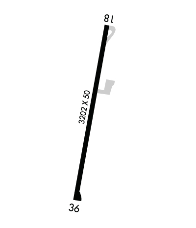
| Lat: N 3054.8 Long: W 09557.1 Elev: 287 Var: -07 Longest Runway: 3202 | ||
| CTAF: 122.9 | ||
| ||||||||||||||||||||||||||||||||
| ||||||||||||||||||||||||||||||||
| Rwy | Rwy | |||||||
| 3202x50 | 3202' | 3202x50 | 3202' | |||||
| Runway ID | Single Wheel | Double Wheel | Double Tandem Wheel | Dual Double Wheel |
| 18/36 | 4,000 | N/A | N/A | N/A |
| These numbers are Advisory and are not limits. The Airport Manager should have more accurate Weight Limits | ||||
 Airport Diagram might not be current. | |
| Facility Name: | MADISONVILLE MUNI |
| City Name: | MADISONVILLE |
| County: | MADISON |
| State abbrev: | TX |
| State Name: | TEXAS |
| Ownership: | PUBLICLY OWNED |
| Use: | OPEN TO THE PUBLIC |
| Owner's Name: | CITY OF MADISONVILLE |
| Address: | 210 W. COTTONWOOD |
| MADISONVILLE, TX 77864 | |
| Owner's Phone: | 936-348-2748 |
| Manager's Name: | CAMILLA VIATOR |
| Address: | 210 W. COTTONWOOD |
| MADISONVILLE, TX 77864 | |
| Phone: | 936-348-2748 |
| FAA Region: | SOUTHWEST |
| FAA Field Office: | TEX |
| Date | Sunrise | Sunset |
|---|---|---|
| 09/24/21 Friday | 7:13 | 19:18 |
| 09/25/21 Saturday | 7:14 | 19:17 |
| 09/26/21 Sunday | 7:14 | 19:16 |
| 09/27/21 Monday | 7:15 | 19:14 |
| 09/28/21 Tuesday | 7:15 | 19:13 |
| 09/29/21 Wednesday | 7:16 | 19:12 |
| 09/30/21 Thursday | 7:17 | 19:10 |
| 10/01/21 Friday | 7:17 | 19:09 |
| 10/02/21 Saturday | 7:18 | 19:08 |
| 10/03/21 Sunday | 7:19 | 19:07 |
| 10/04/21 Monday | 7:19 | 19:05 |
| 10/05/21 Tuesday | 7:20 | 19:04 |
| 10/06/21 Wednesday | 7:20 | 19:03 |
| 10/07/21 Thursday | 7:21 | 19:02 |
| Airport Attendance Schedule | UNATTENDED |
| Airport Status | OPERATIONAL (This Status can change at any time - please check NOTAMS) |
| Airport Lighting Schedule | SS-SR |
| Airport Storage Available | Tie Downs |
| Extra Services Available | Flight Instruction, Parachute Jumping |
| Wind Indicator | YES - (lighted) |
| Control Tower | NO |
| CTAF Frequency | 122.900 |
| Unicom Frequency | |
| Rotating Beacon Color | CLEAR-GREEN (Light Land Airport) |
| Segmented Circle | YES |
| Landing Fee | NO |
| Airport Inspected | STATE - performed by PRIVATE CONTRACT PERSONNEL |
| Inspection Date | 04/14/2019 |
| Type of Fuel Available | Grade 100LL, JET A (freeze point -40C) |
| Airframe Repair Service | NONE |
| Power Plant Repair Service | NONE |
| Latitude | N3054.8 |
| Longitude | W09557.1 (ESTIMATED) |
| Arpt Elevation | 286ft (SURVEYED) |
| Magnetic Variation | 07E |
| 3 miles SW | of MADISONVILLE |
| Traffic Pattern Altitude | |
| Sectional Chart | HOUSTON |
| Operations (Reported) | Yearly | Avg. Daily |
|---|---|---|
| General Aviation Transient | 1000 | 3 |
| General Aviation Local | 2000 | 5 |
| Air Taxi | 0 | 0 |
| Commerical | 0 | 0 |
| Commuter | 0 | 0 |
| Military | 0 | 0 |
| Aircraft based on Field | |
|---|---|
| General Aviation Singles | 3 |
| General Aviation Multi | 0 |
| Jet Aircraft | 0 |
| General Aviation Helicopters | 0 |
| Military Aircraft | 0 |
| Gliders | 0 |
| Ultralights | 0 |
| FSS on field | NO |
| FSS tie-in | MONTGOMERY COUNTY |
| FSS Phone | 1-800-WX-BRIEF |
| Who issues Notams | CXO |
| Notam D service at airport | YES |
| ARTCC Name | HOUSTON |
| Airport Certification | |
| Aircraft Rescue & Firefighting Index | None |
| Airport of Entry | No |
| Custom Landing Rights | No |
| Joint Civil/Military | No |
| Military Landing rights | No |
| THIS AIRPORT HAS BEEN SURVEYED BY THE NATIONAL GEODETIC SURVEY. |
| AIRPORT GATE LOCKED FROM 2200-0600 CALL 936-348-2748. |
| SELF SERVICE AVBL 24/7. |
| SKYDIVING ACTIVITY. |
| FOR CD CTC HOUSTON ARTCC AT 281-230-5622. |
| RWY 18/3 6 RWY MARKINGS FADED. |
Airport Communications & Frequencies:
| |||||||
| Runway: 18 | Runway: 36 | ||
| Mag heading: | 183° | Mag heading: | 3° |
| Rwy Slope: | -.83% Down | Rwy Slope: | .83% Up |
| Approach: | Approach: | ||
| Pattern: | Left Traffic | Pattern: | Left Traffic |
| Markings: | NONPRECISION INSTRUMENT | Markings: | NONPRECISION INSTRUMENT |
| Marking Condition: | POOR | Marking Condition: | POOR |
| Arresting Dev: | Arresting Dev: | ||
| Lat & Long: | N3055.0 W09557.1 | Lat. & Long.: | N3054.5 W09557.2 |
| Elev: | 286.7 ft. MSL | Elev: | 260.2 ft. MSL |
| TCH: | TCH: | ||
| Visual Glide Path: | Visual Glide Path: | ||
| Displaced Threshold: | No | Displaced Threshold: | No |
| Touchdown Zone: | YES | Touchdown Zone: | YES |
| Touchdown Elev.: | 286.7 feet | Touchdown Elev.: | 283.1 feet |
| Visual Glide Slope: | Visual Glide Slope: | ||
| RVR Equipment: | RVR Equipment: | ||
| RVV Equipment: | NO | RVV Equipment: | NO |
| Approach Lights: | Approach Lights: | ||
| REIL: | NO | REIL: | NO |
| Centerline Lights: | NO | Centerline Lights: | NO |
| Touchdown lights: | NO | Touchdown lights: | NO |
| Runway Category: | Runway with a Non-precision Approach | Runway Category: | Runway with a Non-precision Approach |
| Declared Distances: | Declared Distances: | ||
| Obstructions: | TREES | Obstructions: | TREES |
| Marked: | NOT Marked/Lighted | Marked: | NOT Marked/Lighted |
| Clearance slope: | Clearance slope: | ||
| Obstruction height: | 61 feet AGL | Obstruction height: | 50 feet AGL |
| Dist. from runway: | 201 feet | Dist. from runway: | 201 feet |
| Centerline offset: | 190 right of centerline | Centerline offset: | 190 feet left of centerline |
| Comments: | 50 FT TREES 180 FT R & 190 FT L, 0-199 FT DSTC. | Comments: | +50 FT TREES 180 FT L & 200 FT R, 0-199 FT DSTC. |
Thanks for using FltPlan.com
all rights reserved © 1999-2021 by Flight Plan LLC
