
| ANTELOPE COUNTY NELIGH NE |
| |
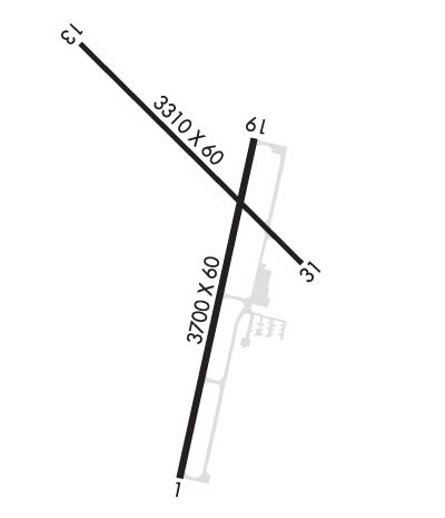
| Lat: N 4206.7 Long: W 09802.4 Elev: 1774 Var: -05 Longest Runway: 3700 | ||
| CTAF: 122.8 | ||
| ||||||
|
| Rwy | Rwy | |||||||
| 3700x60 | 3700' | 3700x60 | 3700' | |||||
| 3310x60 | 2905' | 3310x60 | 2905' | |||||
| Runway ID | Single Wheel | Double Wheel | Double Tandem Wheel | Dual Double Wheel |
| 01/19 | N/A | N/A | N/A | N/A |
| 13/31 | 12,500 | N/A | N/A | N/A |
| These numbers are Advisory and are not limits. The Airport Manager should have more accurate Weight Limits | ||||
 Airport Diagram might not be current. | |
| Facility Name: | ANTELOPE COUNTY |
| City Name: | NELIGH |
| County: | ANTELOPE |
| State abbrev: | NE |
| State Name: | NEBRASKA |
| Ownership: | PUBLICLY OWNED |
| Use: | OPEN TO THE PUBLIC |
| Owner's Name: | ANTELOPE CO ARPT AUTH |
| Address: | 84773 AIRPORT RD |
| NELIGH, NE 68756-5001 | |
| Owner's Phone: | 402-887-4827 |
| Manager's Name: | ADDNL CTC: BRIAN WHITESEL 402-649-4172 OR JOE MCNALLY 402-650-2520. AUTHORITY CHAIRMAN IS RICK SCHINDLER, SAME CONTACT INFO AS OWNER |
| Address: | |
| 05001-5001 | |
| Phone: | |
| FAA Region: | CENTRAL |
| FAA Field Office: | NONE |
| Date | Sunrise | Sunset |
|---|---|---|
| 06/12/26 Friday | 5:56 | 21:08 |
| 06/13/26 Saturday | 5:56 | 21:09 |
| 06/14/26 Sunday | 5:56 | 21:09 |
| 06/15/26 Monday | 5:56 | 21:10 |
| 06/16/26 Tuesday | 5:56 | 21:10 |
| 06/17/26 Wednesday | 5:56 | 21:11 |
| 06/18/26 Thursday | 5:56 | 21:11 |
| 06/19/26 Friday | 5:56 | 21:11 |
| 06/20/26 Saturday | 5:56 | 21:11 |
| 06/21/26 Sunday | 5:56 | 21:12 |
| 06/22/26 Monday | 5:56 | 21:12 |
| 06/23/26 Tuesday | 5:57 | 21:12 |
| 06/24/26 Wednesday | 5:57 | 21:12 |
| 06/25/26 Thursday | 5:57 | 21:12 |
| Airport Attendance Schedule | MON-FRI 0800-1700 |
| Airport Status | OPERATIONAL (This Status can change at any time - please check NOTAMS) |
| Airport Lighting Schedule | ACTVT PAPI RY 01/19; MIRL RY 01/19 - CTAF; AFT 2000 ACTVT MIRL RY 13/31 - CTAF. |
| Airport Storage Available | Tie Downs, Hanger |
| Extra Services Available | Crop Dusting |
| Wind Indicator | YES - (lighted) |
| Control Tower | NO |
| CTAF Frequency | 122.800 |
| Unicom Frequency | 122.800 |
| Rotating Beacon Color | WG |
| Segmented Circle | NO |
| Landing Fee | NO |
| Airport Inspected | STATE - performed by STATE AERONAUTICAL PERSONNEL |
| Inspection Date | 05/08/2025 |
| Type of Fuel Available | Grade 100LL |
| Airframe Repair Service | NONE |
| Power Plant Repair Service | NONE |
| Latitude | N4206.7 |
| Longitude | W09802.4 (ESTIMATED) |
| Arpt Elevation | 1773ft (SURVEYED) |
| Magnetic Variation | 05E |
| 1 miles SW | of NELIGH |
| Traffic Pattern Altitude | |
| Sectional Chart | OMAHA |
| Operations (Reported) | Yearly | Avg. Daily |
|---|---|---|
| General Aviation Transient | 0 | 0 |
| General Aviation Local | 0 | 0 |
| Air Taxi | 0 | 0 |
| Commerical | 0 | 0 |
| Commuter | 0 | 0 |
| Military | 0 | 0 |
| Aircraft based on Field | |
|---|---|
| General Aviation Singles | 0 |
| General Aviation Multi | 0 |
| Jet Aircraft | 0 |
| General Aviation Helicopters | 0 |
| Military Aircraft | 0 |
| Gliders | 0 |
| Ultralights | 0 |
| FSS on field | NO |
| FSS tie-in | COLUMBUS |
| FSS Phone | 1-800-WX-BRIEF |
| Who issues Notams | OLU |
| Notam D service at airport | YES |
| ARTCC Name | MINNEAPOLIS |
| Airport Certification | |
| Aircraft Rescue & Firefighting Index | None |
| Airport of Entry | No |
| Custom Landing Rights | No |
| Joint Civil/Military | No |
| Military Landing rights | YES |
| NATIONAL PLAN OF INTEGRATED AIRPORT SYSTEMS (NPIAS) |
| ASSURANCES PURSUANT TO TITLE VI, CIVIL RIGHTS ACT OF 1964 |
| GRANT AGREEMENT HAS EXPIRED; HOWEVER, AGREEMENT REMAINS IN EFFECT FOR THIS FACILITY AS LONG AS IT IS PUBLIC USE. |
| UNICOM UNMON. |
| FOR CD CTC MINNEAPOLIS ARTCC AT 651-463-5588. |
| COURTESY CAR AVBL. |
Airport Communications & Frequencies:
| |||||||||
| Runway: 01 | Runway: 19 | ||
| Mag heading: | 8° | Mag heading: | 188° |
| Rwy Slope: | -1.15% Down | Rwy Slope: | 1.15% Up |
| Approach: | Approach: | ||
| Pattern: | Left Traffic | Pattern: | Left Traffic |
| Markings: | NONPRECISION INSTRUMENT | Markings: | NONPRECISION INSTRUMENT |
| Marking Condition: | GOOD | Marking Condition: | GOOD |
| Arresting Dev: | Arresting Dev: | ||
| Lat & Long: | N4206.3 W09802.4 | Lat. & Long.: | N4206.9 W09802.3 |
| Elev: | 1773.7 ft. MSL | Elev: | 1731.3 ft. MSL |
| TCH: | 41 ft. AGL | TCH: | 41 ft. AGL |
| Visual Glide Path: | 3.00 degrees | Visual Glide Path: | 3.50 degrees |
| Displaced Threshold: | No | Displaced Threshold: | No |
| Touchdown Zone: | YES | Touchdown Zone: | YES |
| Touchdown Elev.: | 1773.7 feet | Touchdown Elev.: | 1762.0 feet |
| Visual Glide Slope: | 2-Light PAPI on LEFT side of Runway | Visual Glide Slope: | 2-Light PAPI on LEFT side of Runway |
| RVR Equipment: | RVR Equipment: | ||
| RVV Equipment: | NO | RVV Equipment: | NO |
| Approach Lights: | Approach Lights: | ||
| REIL: | NO | REIL: | NO |
| Centerline Lights: | NO | Centerline Lights: | NO |
| Touchdown lights: | NO | Touchdown lights: | NO |
| Runway Category: | Runway with a Non-precision Approach | Runway Category: | Runway with a Non-precision Approach |
| Declared Distances: | Declared Distances: |
| Runway: 13 | Runway: 31 | ||
| Mag heading: | 129° | Mag heading: | 309° |
| Rwy Slope: | -.16% Down | Rwy Slope: | .16% Up |
| Approach: | Approach: | ||
| Pattern: | Left Traffic | Pattern: | Left Traffic |
| Markings: | BASIC | Markings: | BASIC |
| Marking Condition: | GOOD | Marking Condition: | GOOD |
| Arresting Dev: | Arresting Dev: | ||
| Lat & Long: | N4207.1 W09802.7 | Lat. & Long.: | N4206.7 W09802.2 |
| Elev: | 1735.1 ft. MSL | Elev: | 1729.7 ft. MSL |
| TCH: | TCH: | ||
| Visual Glide Path: | Visual Glide Path: | ||
| Displaced Threshold: | 405 feet | Displaced Threshold: | 405 feet |
| Touchdown Zone: | YES | Touchdown Zone: | YES |
| Touchdown Elev.: | 1734.7 feet | Touchdown Elev.: | 1734.7 feet |
| Visual Glide Slope: | Visual Glide Slope: | ||
| RVR Equipment: | RVR Equipment: | ||
| RVV Equipment: | NO | RVV Equipment: | NO |
| Approach Lights: | Approach Lights: | ||
| REIL: | NO | REIL: | NO |
| Centerline Lights: | NO | Centerline Lights: | NO |
| Touchdown lights: | NO | Touchdown lights: | NO |
| Runway Category: | Runway with a Visual Approach | Runway Category: | Runway with a Visual Approach |
| Declared Distances: | TORA:3310' TODA:3310' ASDA:3310' LDA:2905' | Declared Distances: | TORA:3310' TODA:3310' ASDA:3310' LDA:2905' |
| Obstructions: | ROAD; RWY 13 ALSO WATCH SVC ROAD 350 FT FM END 39 FT R GOING S 200 FT FM END 125 FT R CONTG S. | Obstructions: | ROAD |
| Marked: | NOT Marked/Lighted | Marked: | NOT Marked/Lighted |
| Clearance slope: | 2:1; RWY 13 ROAD 644 FT FM DSPLCD THR APCH RATIO 40:1. | Clearance slope: | 1:1; RWY 31 60 FT TREE 1754 FT FM DSPLCD THR 269 FT R APCH RATIO 29:1. |
| Obstruction height: | 16 feet AGL | Obstruction height: | 10 feet AGL |
| Dist. from runway: | 239 feet | Dist. from runway: | 201 feet |
| Centerline offset: | Centerline offset: | ||
| Comments: | RWY 13 6 FT FENCE 200 FT FM END, 90 FT R CONTN S. | Comments: | RWY 31 ROAD 169 FT FM END 89 FT R. |
Thanks for using FltPlan.com
all rights reserved © 1999-2026 by Flight Plan LLC
