
| KEN JERNSTEDT AIRFIELD HOOD RIVER OR |
| |
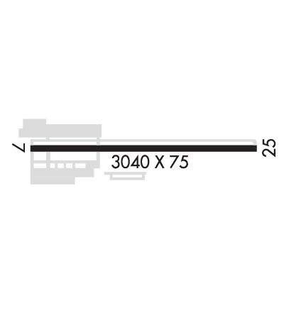
| Lat: N 4540.4 Long: W 12132.0 Elev: 638 Var: -19 Longest Runway: 3040 | ||
| AWOS: 134.37 CTAF: 122.8 | ||
| ||||||||||||||||||||||||||||||||||||||||||||
| ||||||||||||||||||||||||||||||||||||||||||||
| ||||||||||||||||||||||||||||||||||||||||||||
| Rwy | Rwy | |||||||
| 3040x75 | 3040' | 3040x75 | 3040' | |||||
| Runway ID | Single Wheel | Double Wheel | Double Tandem Wheel | Dual Double Wheel |
| 07/25 | 23,000 | N/A | N/A | N/A |
| These numbers are Advisory and are not limits. The Airport Manager should have more accurate Weight Limits | ||||
| FltPlan does not have IFR approach charts available for K4S2. |
 Airport Diagram might not be current. | |
| Facility Name: | KEN JERNSTEDT AIRFIELD |
| City Name: | HOOD RIVER |
| County: | HOOD RIVER |
| State abbrev: | OR |
| State Name: | OREGON |
| Ownership: | PUBLICLY OWNED |
| Use: | OPEN TO THE PUBLIC |
| Owner's Name: | PORT OF HOOD RIVER |
| Address: | 1000 E. PORT MARINA DRIVE |
| HOOD RIVER, OR 97031 | |
| Owner's Phone: | 541-386-1645 |
| Manager's Name: | JEFF RENARD |
| Address: | 1000 E. PORT MARINA DRIVE |
| HOOD RIVER, OR 97031 | |
| Phone: | 541-386-1645 |
| FAA Region: | NORTHWEST MOUNTAIN |
| FAA Field Office: | SEA |
| Date | Sunrise | Sunset |
|---|---|---|
| 09/24/21 Friday | 6:55 | 19:00 |
| 09/25/21 Saturday | 6:57 | 18:58 |
| 09/26/21 Sunday | 6:58 | 18:56 |
| 09/27/21 Monday | 6:59 | 18:54 |
| 09/28/21 Tuesday | 7:00 | 18:52 |
| 09/29/21 Wednesday | 7:02 | 18:50 |
| 09/30/21 Thursday | 7:03 | 18:48 |
| 10/01/21 Friday | 7:04 | 18:47 |
| 10/02/21 Saturday | 7:05 | 18:45 |
| 10/03/21 Sunday | 7:07 | 18:43 |
| 10/04/21 Monday | 7:08 | 18:41 |
| 10/05/21 Tuesday | 7:09 | 18:39 |
| 10/06/21 Wednesday | 7:11 | 18:37 |
| 10/07/21 Thursday | 7:12 | 18:35 |
| Airport Attendance Schedule | NOV-APR 7 Days A Week 0800-1700, MAY-OCT 7 Days A Week 0800-1800 |
| Airport Status | OPERATIONAL (This Status can change at any time - please check NOTAMS) |
| Airport Lighting Schedule | ACTVT MIRL RY 07/25; REIL RWY 25 - CTAF. |
| Airport Storage Available | Tie Downs |
| Extra Services Available | Crop Dusting, Glider, Flight Instruction, Aircraft Rental, Glider Towing |
| Wind Indicator | YES - (unlit) |
| Control Tower | NO |
| CTAF Frequency | 122.800 |
| Unicom Frequency | 122.800 |
| Rotating Beacon Color | CLEAR-GREEN (Light Land Airport) |
| Segmented Circle | YES |
| Landing Fee | NO |
| Airport Inspected | STATE - performed by STATE AERONAUTICAL PERSONNEL |
| Inspection Date | 09/13/2019 |
| Type of Fuel Available | Grade 100LL |
| Airframe Repair Service | MAJOR |
| Power Plant Repair Service | MAJOR |
| Latitude | N4540.4 |
| Longitude | W12132.0 (ESTIMATED) |
| Arpt Elevation | 638ft (SURVEYED) |
| Magnetic Variation | 19E |
| 2 miles S | of HOOD RIVER |
| Traffic Pattern Altitude | 869 |
| Sectional Chart | SEATTLE |
| Operations (Reported) | Yearly | Avg. Daily |
|---|---|---|
| General Aviation Transient | 9751 | 27 |
| General Aviation Local | 4199 | 12 |
| Air Taxi | 200 | 1 |
| Commerical | 0 | 0 |
| Commuter | 0 | 0 |
| Military | 60 | 0 |
| Aircraft based on Field | |
|---|---|
| General Aviation Singles | 125 |
| General Aviation Multi | 1 |
| Jet Aircraft | 0 |
| General Aviation Helicopters | 2 |
| Military Aircraft | 0 |
| Gliders | 16 |
| Ultralights | 0 |
| FSS on field | NO |
| FSS tie-in | MC MINNVILLE |
| FSS Phone | 1-800-WX-BRIEF |
| Who issues Notams | MMV |
| Notam D service at airport | YES |
| ARTCC Name | SEATTLE |
| Airport Certification | |
| Aircraft Rescue & Firefighting Index | None |
| Airport of Entry | No |
| Custom Landing Rights | No |
| Joint Civil/Military | No |
| Military Landing rights | YES |
| NATIONAL PLAN OF INTEGRATED AIRPORT SYSTEMS (NPIAS) |
| GRANT AGREEMENTS UNDER FAAP/ADAP/AIP |
| ASSURANCES PURSUANT TO TITLE VI, CIVIL RIGHTS ACT OF 1964 |
| FREQUENT VEHICULAR TFC AER 7. |
| BLUE EXIT LGTS AT 3 TURNOFFS. |
| FOR CD CTC SEATTLE ARTCC AT 253-351-3694. |
| HOOD RIVER ARPT IS A NOISE SENS AREA. PLS FLW THE FLY FRIENDLY SIGNS AT RWY ENDS AND AVOID LOW FLT. |
| RWY 07/2 5 GLIDERS AND ULTRALIGHTS USE RIGHT TFC. ALT GRASS LNDG AREA AVBL IN MEDIAN, NOT TO BE USED SIMULTANEOUSLY WITH PAVED RWY. |
| Runway: 07 | Runway: 25 | ||
| Mag heading: | 71° | Mag heading: | 251° |
| Rwy Slope: | -1.11% Down | Rwy Slope: | 1.11% Up |
| Approach: | Approach: | ||
| Pattern: | Left Traffic | Pattern: | Left Traffic |
| Markings: | BASIC | Markings: | BASIC |
| Marking Condition: | GOOD | Marking Condition: | GOOD |
| Arresting Dev: | Arresting Dev: | ||
| Lat & Long: | N4540.4 W12132.4 | Lat. & Long.: | N4540.4 W12131.7 |
| Elev: | 631.1 ft. MSL | Elev: | 597.3 ft. MSL |
| TCH: | TCH: | ||
| Visual Glide Path: | Visual Glide Path: | ||
| Displaced Threshold: | No | Displaced Threshold: | No |
| Touchdown Zone: | NO | Touchdown Zone: | NO |
| Touchdown Elev.: | Touchdown Elev.: | ||
| Visual Glide Slope: | Visual Glide Slope: | ||
| RVR Equipment: | RVR Equipment: | ||
| RVV Equipment: | NO | RVV Equipment: | NO |
| Approach Lights: | Approach Lights: | ||
| REIL: | NO | REIL: | YES |
| Centerline Lights: | NO | Centerline Lights: | NO |
| Touchdown lights: | NO | Touchdown lights: | NO |
| Runway Category: | Runway with a Visual Approach | Runway Category: | Runway with a Visual Approach |
| Declared Distances: | Declared Distances: | ||
| Obstructions: | TREE | Obstructions: | TREE |
| Marked: | NOT Marked/Lighted | Marked: | NOT Marked/Lighted |
| Clearance slope: | 10:1 | Clearance slope: | 16:1 |
| Obstruction height: | 111 feet AGL | Obstruction height: | 42 feet AGL |
| Dist. from runway: | 1406 feet | Dist. from runway: | 890 feet |
| Centerline offset: | 210 right of centerline | Centerline offset: | 140 feet right of centerline |
| Comments: | Comments: |
Thanks for using FltPlan.com
all rights reserved © 1999-2021 by Flight Plan LLC
