
| EUNICE EUNICE LA |
| |
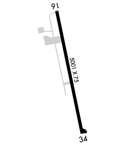
| Lat: N 3028.0 Long: W 09225.4 Elev: 42 Var: -02 Longest Runway: 5001 | ||
| Clr Del: 135.07 GCO CTAF: 122.8 | ||
| ||||||||||||||||||||||||||||||||||||||||||||
| ||||||||||||||||||||||||||||||||||||||||||||
| Rwy | Rwy | |||||||
| 5001x75 | 5001' | 5001x75 | 5001' | |||||
| Runway ID | Single Wheel | Double Wheel | Double Tandem Wheel | Dual Double Wheel |
| 16/34 | 21,000 | N/A | N/A | N/A |
| These numbers are Advisory and are not limits. The Airport Manager should have more accurate Weight Limits | ||||
 Airport Diagram might not be current. | |
| Facility Name: | EUNICE |
| City Name: | EUNICE |
| County: | ACADIA |
| State abbrev: | LA |
| State Name: | LOUISIANA |
| Ownership: | PUBLICLY OWNED |
| Use: | OPEN TO THE PUBLIC |
| Owner's Name: | CITY OF EUNICE |
| Address: | PO BOX 1106 |
| EUNICE, LA 70535 | |
| Owner's Phone: | 337-457-7389 |
| Manager's Name: | DAVID KRESWELL |
| Address: | 252 EUNICE AIRPORT ROAD |
| EUNICE, LA 70535 | |
| Phone: | 337-457-6585 |
| FAA Region: | SOUTHWEST |
| FAA Field Office: | LNM |
| Date | Sunrise | Sunset |
|---|---|---|
| 06/08/26 Monday | 6:07 | 20:11 |
| 06/09/26 Tuesday | 6:07 | 20:11 |
| 06/10/26 Wednesday | 6:07 | 20:11 |
| 06/11/26 Thursday | 6:07 | 20:12 |
| 06/12/26 Friday | 6:07 | 20:12 |
| 06/13/26 Saturday | 6:07 | 20:13 |
| 06/14/26 Sunday | 6:07 | 20:13 |
| 06/15/26 Monday | 6:07 | 20:13 |
| 06/16/26 Tuesday | 6:07 | 20:14 |
| 06/17/26 Wednesday | 6:07 | 20:14 |
| 06/18/26 Thursday | 6:07 | 20:14 |
| 06/19/26 Friday | 6:08 | 20:14 |
| 06/20/26 Saturday | 6:08 | 20:15 |
| 06/21/26 Sunday | 6:08 | 20:15 |
| Airport Attendance Schedule | MON-FRI 0800-1700, SAT ON CALL, SUN ON CALL |
| Airport Status | OPERATIONAL (This Status can change at any time - please check NOTAMS) |
| Airport Lighting Schedule | REIL RWY 16/34 AND MIRL RWY 16/34 PRESET LOW INTST DUSK-DAWN; TO INCR INTST ACTVT - CTAF. |
| Airport Storage Available | Tie Downs, Hanger |
| Extra Services Available | Crop Dusting, Flight Instruction, Aircraft Rental |
| Wind Indicator | YES - (lighted) |
| Control Tower | NO |
| CTAF Frequency | 122.800 |
| Unicom Frequency | 122.800 |
| Rotating Beacon Color | WG |
| Segmented Circle | YES |
| Landing Fee | NO |
| Airport Inspected | STATE - performed by STATE AERONAUTICAL PERSONNEL |
| Inspection Date | 04/18/2023 |
| Type of Fuel Available | Grade 100LL, JET A (freeze point -40C); -10FOR FUEL AFT HRS CALL 337-457-6585. |
| Airframe Repair Service | MINOR |
| Power Plant Repair Service | MINOR |
| Latitude | N3028.0 |
| Longitude | W09225.4 (ESTIMATED) |
| Arpt Elevation | 42ft (SURVEYED) |
| Magnetic Variation | 02E |
| 2 miles S | of EUNICE |
| Traffic Pattern Altitude | |
| Sectional Chart | HOUSTON |
| Operations (Reported) | Yearly | Avg. Daily |
|---|---|---|
| General Aviation Transient | 0 | 0 |
| General Aviation Local | 0 | 0 |
| Air Taxi | 0 | 0 |
| Commerical | 0 | 0 |
| Commuter | 0 | 0 |
| Military | 0 | 0 |
| Aircraft based on Field | |
|---|---|
| General Aviation Singles | 0 |
| General Aviation Multi | 0 |
| Jet Aircraft | 0 |
| General Aviation Helicopters | 0 |
| Military Aircraft | 0 |
| Gliders | 0 |
| Ultralights | 0 |
| FSS on field | NO |
| FSS tie-in | DE RIDDER |
| FSS Phone | 1-800-WX-BRIEF |
| Who issues Notams | DRI |
| Notam D service at airport | YES |
| ARTCC Name | HOUSTON |
| Airport Certification | |
| Aircraft Rescue & Firefighting Index | None |
| Airport of Entry | No |
| Custom Landing Rights | No |
| Joint Civil/Military | No |
| Military Landing rights | YES |
| NATIONAL PLAN OF INTEGRATED AIRPORT SYSTEMS (NPIAS) |
| GRANT AGREEMENTS UNDER FAAP/ADAP/AIP |
| ASSURANCES PURSUANT TO TITLE VI, CIVIL RIGHTS ACT OF 1964 |
| THIS AIRPORT HAS BEEN SURVEYED BY THE NATIONAL GEODETIC SURVEY. |
| GCO AVBL ON FREQ 135.075 THRU LAFAYETTE APCH & DRI FSS. |
| FOR CD CTC LAFAYETTE APCH AT 337-262-2729, WHEN APCH CLSD CTC HOUSTON ARTCC AT 281-230-5622. |
| CTC APRT MGR FOR DSGND RAMP SPACE FOR PUB USE. |
Airport Communications & Frequencies:
| |||||||||||||||||
| Runway: 16 | Runway: 34 | ||
| Mag heading: | 164° | Mag heading: | 344° |
| Rwy Slope: | .06% Up | Rwy Slope: | -.06% Down |
| Approach: | Approach: | ||
| Pattern: | Left Traffic | Pattern: | Left Traffic |
| Markings: | NONPRECISION INSTRUMENT | Markings: | NONPRECISION INSTRUMENT |
| Marking Condition: | POOR; RUNWAY MARKINGS SEVERELY FADED | Marking Condition: | POOR; RUNWAY MARKINGS SEVERELY FADED |
| Arresting Dev: | Arresting Dev: | ||
| Lat & Long: | N3028.4 W09225.5 | Lat. & Long.: | N3027.6 W09225.3 |
| Elev: | 39.0 ft. MSL | Elev: | 42.0 ft. MSL |
| TCH: | 50 ft. AGL | TCH: | 50 ft. AGL |
| Visual Glide Path: | 3.00 degrees | Visual Glide Path: | 3.00 degrees |
| Displaced Threshold: | No | Displaced Threshold: | No |
| Touchdown Zone: | YES | Touchdown Zone: | YES |
| Touchdown Elev.: | 40.0 feet | Touchdown Elev.: | 42.0 feet |
| Visual Glide Slope: | 2-Light PAPI on LEFT side of Runway; RWY 16 PAPI UNUSBL BYD 6 DEGS LEFT OF CNTRLN. | Visual Glide Slope: | 2-Light PAPI on LEFT side of Runway |
| RVR Equipment: | RVR Equipment: | ||
| RVV Equipment: | NO | RVV Equipment: | NO |
| Approach Lights: | Approach Lights: | ||
| REIL: | YES | REIL: | YES |
| Centerline Lights: | NO | Centerline Lights: | NO |
| Touchdown lights: | NO | Touchdown lights: | NO |
| Runway Category: | Runway with a Non-precision Approach | Runway Category: | Runway with a Non-precision Approach |
| Declared Distances: | Declared Distances: | ||
| Obstructions: | TREES | Obstructions: | TREES |
| Marked: | NOT Marked/Lighted | Marked: | NOT Marked/Lighted |
| Clearance slope: | 16:1 | Clearance slope: | 20:1 |
| Obstruction height: | 67 feet AGL | Obstruction height: | 48 feet AGL |
| Dist. from runway: | 1304 feet | Dist. from runway: | 1179 feet |
| Centerline offset: | 10 right of centerline | Centerline offset: | 311 feet left of centerline |
| Comments: | Comments: |
Thanks for using FltPlan.com
all rights reserved © 1999-2026 by Flight Plan LLC
