
| LEXINGTON MUNI LEXINGTON MO |
| |
| Lat: N 3912.6 Long: W 09355.7 Elev: 691 Var: -04 Longest Runway: 3100 | ||
| CTAF: 122.7 | ||
| ||||||||||||||||||||||||||||||||
| ||||||||||||||||||||||||||||||||
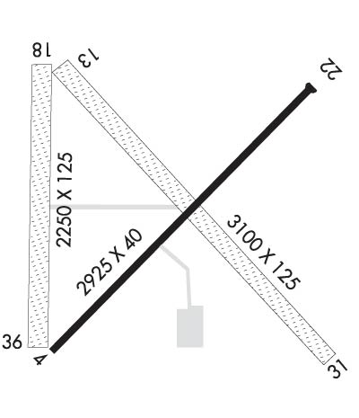
| Rwy | Rwy | |||||||
| 2925x40 | 2925' | 2925x40 | 2925' | |||||
| 3100x125 | 3100' | 3100x125 | 3100' | |||||
| 2250x125 | 2250' | 2250x125 | 2250' | |||||
| Runway ID | Single Wheel | Double Wheel | Double Tandem Wheel | Dual Double Wheel |
| 04/22 | N/A | N/A | N/A | N/A |
| 13/31 | N/A | N/A | N/A | N/A |
| 18/36 | N/A | N/A | N/A | N/A |
| These numbers are Advisory and are not limits. The Airport Manager should have more accurate Weight Limits | ||||
| FltPlan does not have IFR approach charts available for K4K3. |
 Airport Diagram might not be current. | |
| Facility Name: | LEXINGTON MUNI |
| City Name: | LEXINGTON |
| County: | RAY |
| State abbrev: | MO |
| State Name: | MISSOURI |
| Ownership: | PRIVATELY OWNED |
| Use: | OPEN TO THE PUBLIC |
| Owner's Name: | DAVID EDWARDS |
| Address: | 11215 GREAT CANADIAN LANE |
| RICHMOND, MO 64085 | |
| Owner's Phone: | (816) 752-5333 |
| Manager's Name: | DAVID EDWARDS |
| Address: | 11215 GREAT CANADIAN LANE |
| RICHMOND, MO 64085 | |
| Phone: | (816) 752-5333 |
| FAA Region: | CENTRAL |
| FAA Field Office: | NONE |
| Date | Sunrise | Sunset |
|---|---|---|
| 10/06/21 Wednesday | 7:16 | 18:51 |
| 10/07/21 Thursday | 7:17 | 18:49 |
| 10/08/21 Friday | 7:18 | 18:48 |
| 10/09/21 Saturday | 7:19 | 18:46 |
| 10/10/21 Sunday | 7:20 | 18:45 |
| 10/11/21 Monday | 7:21 | 18:43 |
| 10/12/21 Tuesday | 7:22 | 18:42 |
| 10/13/21 Wednesday | 7:23 | 18:40 |
| 10/14/21 Thursday | 7:24 | 18:39 |
| 10/15/21 Friday | 7:25 | 18:37 |
| 10/16/21 Saturday | 7:26 | 18:36 |
| 10/17/21 Sunday | 7:27 | 18:34 |
| 10/18/21 Monday | 7:28 | 18:33 |
| 10/19/21 Tuesday | 7:29 | 18:32 |
| Airport Attendance Schedule | IRREGULAR ALL |
| Airport Status | OPERATIONAL (This Status can change at any time - please check NOTAMS) |
| Airport Lighting Schedule | |
| Airport Storage Available | Tie Downs, Hanger |
| Extra Services Available | Crop Dusting |
| Wind Indicator | YES - (unlit) |
| Control Tower | NO |
| CTAF Frequency | 122.700 |
| Unicom Frequency | 122.700 |
| Rotating Beacon Color | |
| Segmented Circle | NO |
| Landing Fee | NO |
| Airport Inspected | STATE - performed by STATE AERONAUTICAL PERSONNEL |
| Inspection Date | 06/19/2019 |
| Type of Fuel Available | None |
| Airframe Repair Service | None |
| Power Plant Repair Service | None |
| Latitude | N3912.6 |
| Longitude | W09355.7 (ESTIMATED) |
| Arpt Elevation | 691ft (SURVEYED) |
| Magnetic Variation | 04E |
| 3 miles NW | of LEXINGTON |
| Traffic Pattern Altitude | |
| Sectional Chart | KANSAS CITY |
| Operations (Reported) | Yearly | Avg. Daily |
|---|---|---|
| General Aviation Transient | 1500 | 4 |
| General Aviation Local | 2800 | 8 |
| Air Taxi | 250 | 1 |
| Commerical | 0 | 0 |
| Commuter | 0 | 0 |
| Military | 250 | 1 |
| Aircraft based on Field | |
|---|---|
| General Aviation Singles | 2 |
| General Aviation Multi | 0 |
| Jet Aircraft | 0 |
| General Aviation Helicopters | 0 |
| Military Aircraft | 0 |
| Gliders | 0 |
| Ultralights | 0; ULTRALIGHT ACTIVITY & RADIO CONTROLLED AIRPLANES ON & INVOF ARPT. |
| FSS on field | NO |
| FSS tie-in | COLUMBIA |
| FSS Phone | 1-800-WX-BRIEF |
| Who issues Notams | COU |
| Notam D service at airport | YES |
| ARTCC Name | KANSAS CITY |
| Airport Certification | |
| Aircraft Rescue & Firefighting Index | None |
| Airport of Entry | No |
| Custom Landing Rights | No |
| Joint Civil/Military | No |
| Military Landing rights | YES |
| MIGRATORY BIRDS INVOF ARPT DURING SPRING AND FALL. |
| NTSD RWY SAFETY AREA RWY22; INCORRECT TERRAIN GRADES. |
| FOR CD CTC KANSAS CITY ARTCC AT 913-254-8508. |
| RWY 04/2 2 RY 04/22 ROUGH, LARGE PITS IN SFC, CRACKS. |
Airport Communications & Frequencies:
| |||||||||
| Runway: 04 | Runway: 22 | ||
| Mag heading: | 38° | Mag heading: | 218° |
| Rwy Slope: | -.07% Down | Rwy Slope: | .07% Up |
| Approach: | Approach: | ||
| Pattern: | Left Traffic | Pattern: | Left Traffic |
| Markings: | Markings: | ||
| Marking Condition: | Marking Condition: | ||
| Arresting Dev: | Arresting Dev: | ||
| Lat & Long: | N3912.4 W09355.8 | Lat. & Long.: | N3912.8 W09355.4 |
| Elev: | 691.0 ft. MSL | Elev: | 689.0 ft. MSL |
| TCH: | TCH: | ||
| Visual Glide Path: | Visual Glide Path: | ||
| Displaced Threshold: | No | Displaced Threshold: | No |
| Touchdown Zone: | YES | Touchdown Zone: | NO |
| Touchdown Elev.: | 691.0 feet | Touchdown Elev.: | |
| Visual Glide Slope: | Visual Glide Slope: | ||
| RVR Equipment: | RVR Equipment: | ||
| RVV Equipment: | NO | RVV Equipment: | NO |
| Approach Lights: | Approach Lights: | ||
| REIL: | NO | REIL: | NO |
| Centerline Lights: | NO | Centerline Lights: | NO |
| Touchdown lights: | NO | Touchdown lights: | NO |
| Runway Category: | Runway with a Visual Approach | Runway Category: | Runway with a Visual Approach |
| Declared Distances: | Declared Distances: | ||
| Obstructions: | ROAD | Obstructions: | |
| Marked: | NOT Marked/Lighted | Marked: | |
| Clearance slope: | 8:1 | Clearance slope: | 20:1 |
| Obstruction height: | 14 feet AGL | Obstruction height: | |
| Dist. from runway: | 325 feet | Dist. from runway: | |
| Centerline offset: | 130 right of centerline | Centerline offset: | |
| Comments: | Comments: |
| Runway: 13 | Runway: 31 | ||
| Mag heading: | 132° | Mag heading: | 312° |
| Rwy Slope: | .00% | Rwy Slope: | .00% |
| Approach: | Approach: | ||
| Pattern: | Left Traffic | Pattern: | Left Traffic |
| Markings: | Markings: | ||
| Marking Condition: | Marking Condition: | ||
| Arresting Dev: | Arresting Dev: | ||
| Lat & Long: | N3912.8 W09355.8 | Lat. & Long.: | N3912.4 W09355.4 |
| Elev: | 690.0 ft. MSL | Elev: | 690.0 ft. MSL |
| TCH: | TCH: | ||
| Visual Glide Path: | Visual Glide Path: | ||
| Displaced Threshold: | No | Displaced Threshold: | No |
| Touchdown Zone: | NO | Touchdown Zone: | NO |
| Touchdown Elev.: | Touchdown Elev.: | ||
| Visual Glide Slope: | Visual Glide Slope: | ||
| RVR Equipment: | RVR Equipment: | ||
| RVV Equipment: | NO | RVV Equipment: | NO |
| Approach Lights: | Approach Lights: | ||
| REIL: | NO | REIL: | NO |
| Centerline Lights: | NO | Centerline Lights: | NO |
| Touchdown lights: | NO | Touchdown lights: | NO |
| Runway Category: | Runway with a Visual Approach | Runway Category: | Runway with a Visual Approach |
| Declared Distances: | Declared Distances: | ||
| Obstructions: | PLINE | Obstructions: | ROAD |
| Marked: | MARKED | Marked: | NOT Marked/Lighted |
| Clearance slope: | 11:1 | Clearance slope: | 18:1 |
| Obstruction height: | 29 feet AGL | Obstruction height: | 15 feet AGL |
| Dist. from runway: | 330 feet | Dist. from runway: | 270 feet |
| Centerline offset: | 150 right of centerline | Centerline offset: | 140 feet right of centerline |
| Comments: | Comments: |
| Runway: 18 | Runway: 36 | ||
| Mag heading: | 176° | Mag heading: | 356° |
| Rwy Slope: | .00% | Rwy Slope: | .00% |
| Approach: | Approach: | ||
| Pattern: | Left Traffic | Pattern: | Left Traffic |
| Markings: | Markings: | ||
| Marking Condition: | Marking Condition: | ||
| Arresting Dev: | Arresting Dev: | ||
| Lat & Long: | N3912.8 W09355.8 | Lat. & Long.: | N3912.4 W09355.8 |
| Elev: | 690.0 ft. MSL | Elev: | 690.0 ft. MSL |
| TCH: | TCH: | ||
| Visual Glide Path: | Visual Glide Path: | ||
| Displaced Threshold: | No | Displaced Threshold: | No |
| Touchdown Zone: | NO | Touchdown Zone: | NO |
| Touchdown Elev.: | Touchdown Elev.: | ||
| Visual Glide Slope: | Visual Glide Slope: | ||
| RVR Equipment: | RVR Equipment: | ||
| RVV Equipment: | NO | RVV Equipment: | NO |
| Approach Lights: | Approach Lights: | ||
| REIL: | NO | REIL: | NO |
| Centerline Lights: | NO | Centerline Lights: | NO |
| Touchdown lights: | NO | Touchdown lights: | NO |
| Runway Category: | Runway with a Visual Approach | Runway Category: | Runway with a Visual Approach |
| Declared Distances: | Declared Distances: | ||
| Obstructions: | Obstructions: | ROAD | |
| Marked: | Marked: | NOT Marked/Lighted | |
| Clearance slope: | 20:1 | Clearance slope: | 15:1 |
| Obstruction height: | Obstruction height: | 15 feet AGL | |
| Dist. from runway: | Dist. from runway: | 227 feet | |
| Centerline offset: | Centerline offset: | ||
| Comments: | Comments: |
Thanks for using FltPlan.com
all rights reserved © 1999-2021 by Flight Plan LLC
