
| ST MARYS ST MARYS GA |
| |
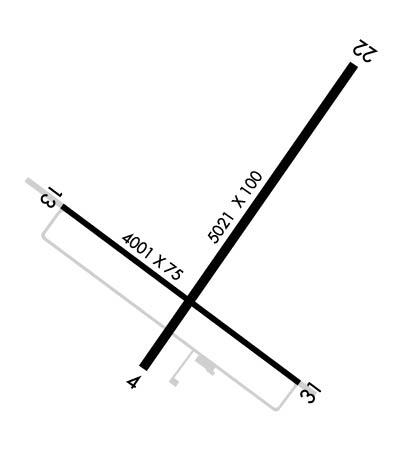
| Lat: N 3045.2 Long: W 08133.5 Elev: 23 Var: +06 Longest Runway: 5021 | ||
| CTAF: 122.8 | ||
| ||||||||||||||||||||||||||||||||
| ||||||||||||||||||||||||||||||||
| Rwy | Rwy | |||||||
| 5021x100 | 4263' | 5021x100 | 4040' | |||||
| 4001x75 | 3302' | 4001x75 | 3301' | |||||
| Runway ID | Single Wheel | Double Wheel | Double Tandem Wheel | Dual Double Wheel |
| These numbers are Advisory and are not limits. The Airport Manager should have more accurate Weight Limits | ||||
| FltPlan does not have IFR approach charts available for K4J6. |
 Airport Diagram might not be current. | |
| Facility Name: | ST MARYS |
| City Name: | ST MARYS |
| County: | CAMDEN |
| State abbrev: | GA |
| State Name: | GEORGIA |
| Ownership: | PUBLICLY OWNED |
| Use: | OPEN TO THE PUBLIC |
| Owner's Name: | CITY OF ST MARYS |
| Address: | CITY HALL, 418 OSBORNE ST. |
| ST MARYS, GA 31558 | |
| Owner's Phone: | (912) 510-4043 |
| Manager's Name: | JOHN HOLMAN, CITY MANAGER |
| Address: | 418 OSBORNE STREET |
| ST MARYS, GA 31558 | |
| Phone: | (912) 510-4043 |
| FAA Region: | SOUTHERN |
| FAA Field Office: | ATL |
| Date | Sunrise | Sunset |
|---|---|---|
| 11/07/18 Wednesday | 6:46 | 17:34 |
| 11/08/18 Thursday | 6:47 | 17:33 |
| 11/09/18 Friday | 6:47 | 17:32 |
| 11/10/18 Saturday | 6:48 | 17:32 |
| 11/11/18 Sunday | 6:49 | 17:31 |
| 11/12/18 Monday | 6:50 | 17:31 |
| 11/13/18 Tuesday | 6:51 | 17:30 |
| 11/14/18 Wednesday | 6:52 | 17:29 |
| 11/15/18 Thursday | 6:53 | 17:29 |
| 11/16/18 Friday | 6:53 | 17:28 |
| 11/17/18 Saturday | 6:54 | 17:28 |
| 11/18/18 Sunday | 6:55 | 17:28 |
| 11/19/18 Monday | 6:56 | 17:27 |
| 11/20/18 Tuesday | 6:57 | 17:27 |
| Airport Attendance Schedule | 7 Days A Week 0900-1700 |
| Airport Status | CLOSED PERMANENTLY (This Status can change at any time - please check NOTAMS) |
| Airport Lighting Schedule | MIRL RY 04/22 & 13/31 PRESET LOW INTST; TO INCR INTST ACTVT - CTAF. |
| Airport Storage Available | Tie Downs |
| Extra Services Available | Flight Instruction |
| Wind Indicator | YES - (lighted) |
| Control Tower | NO |
| CTAF Frequency | 122.800 |
| Unicom Frequency | 122.800 |
| Rotating Beacon Color | CLEAR-GREEN (Light Land Airport) |
| Segmented Circle | YES |
| Landing Fee | NO |
| Airport Inspected | STATE - performed by STATE AERONAUTICAL PERSONNEL |
| Inspection Date | 12/08/2016 |
| Type of Fuel Available | Grade 100LL, JET A-1 (icing inhibitor, freeze point -50C); 100LL SELF SERVICE FUEL WITH CREDIT CARD. |
| Airframe Repair Service | MINOR |
| Power Plant Repair Service | MINOR |
| Latitude | N3045.2 |
| Longitude | W08133.5 (ESTIMATED) |
| Arpt Elevation | 23ft (SURVEYED) |
| Magnetic Variation | 06W |
| 2 miles N | of ST MARYS |
| Traffic Pattern Altitude | |
| Sectional Chart | JACKSONVILLE |
| Operations (Reported) | Yearly | Avg. Daily |
|---|---|---|
| General Aviation Transient | 1985 | 5 |
| General Aviation Local | 1985 | 5 |
| Air Taxi | 0 | 0 |
| Commerical | 0 | 0 |
| Commuter | 0 | 0 |
| Military | 30 | 0 |
| Aircraft based on Field | |
|---|---|
| General Aviation Singles | 13 |
| General Aviation Multi | 1 |
| Jet Aircraft | 0 |
| General Aviation Helicopters | 0 |
| Military Aircraft | 0 |
| Gliders | 0 |
| Ultralights | 10 |
| FSS on field | NO |
| FSS tie-in | MACON |
| FSS Phone | 1-800-WX-BRIEF |
| Who issues Notams | MCN |
| Notam D service at airport | YES |
| ARTCC Name | JACKSONVILLE |
| Airport Certification | |
| Aircraft Rescue & Firefighting Index | None |
| Airport of Entry | No |
| Custom Landing Rights | No |
| Joint Civil/Military | No |
| Military Landing rights | YES |
| NATIONAL PLAN OF INTEGRATED AIRPORT SYSTEMS (NPIAS) |
| GRANT AGREEMENTS UNDER FAAP/ADAP/AIP |
| ASSURANCES PURSUANT TO TITLE VI, CIVIL RIGHTS ACT OF 1964 |
| AGREEMENT UNDER DLAND OR DCLA HAS EXPIRED. |
| RECOMMEND TWO-WAY RADIO COMMUNICATIONS BE UTILIZED WITH JACKSONVILLE APPROACH (127.00), WHILE FLYING IN THE VICINITY OF ST. MARY'S ARPT DUE TO A PROHIBITED AREA (P50) 1/2 TO 2-1/2 MI N, NE OF ARPT (SEE NOTAMS/TFR). |
| (ARPT STATUS) ARPT CLSD PERMLY. |
| Runway: 04 | Runway: 22 | ||
| Mag heading: | 42° | Mag heading: | 222° |
| Rwy Slope: | -.04% Down | Rwy Slope: | .04% Up |
| Approach: | Approach: | ||
| Pattern: | Left Traffic | Pattern: | Left Traffic |
| Markings: | NONPRECISION INSTRUMENT | Markings: | NONPRECISION INSTRUMENT |
| Marking Condition: | FAIR | Marking Condition: | FAIR |
| Arresting Dev: | Arresting Dev: | ||
| Lat & Long: | N3044.9 W08133.7 | Lat. & Long.: | N3045.6 W08133.1 |
| Elev: | 20.9 ft. MSL | Elev: | 18.9 ft. MSL |
| TCH: | TCH: | ||
| Visual Glide Path: | Visual Glide Path: | ||
| Displaced Threshold: | 758 feet | Displaced Threshold: | 981 feet |
| Touchdown Zone: | YES | Touchdown Zone: | YES |
| Touchdown Elev.: | 23.0 feet | Touchdown Elev.: | 23.0 feet |
| Visual Glide Slope: | Visual Glide Slope: | ||
| RVR Equipment: | RVR Equipment: | ||
| RVV Equipment: | NO | RVV Equipment: | NO |
| Approach Lights: | Approach Lights: | ||
| REIL: | NO | REIL: | NO |
| Centerline Lights: | NO | Centerline Lights: | NO |
| Touchdown lights: | NO | Touchdown lights: | NO |
| Runway Category: | Runway with a Non-precision Approach having visibility minimums greater than 3/4 mile | Runway Category: | Runway with a Visual Approach |
| Declared Distances: | Declared Distances: | ||
| Obstructions: | TREES | Obstructions: | TREES |
| Marked: | NOT Marked/Lighted | Marked: | NOT Marked/Lighted |
| Clearance slope: | 8:1; APCH RATIO 34:1 TO DSPLCD THLD; 50 FT TREES 1700FT FM DSPLCD THLD 400 FT RIGHT. | Clearance slope: | APCH RATIO 13:1 TO DSPLCD THLD; 54 FT TREES 702FT FM DSPLCD THLD AND 300 FT RIGHT. |
| Obstruction height: | 39 feet AGL | Obstruction height: | 20 feet AGL |
| Dist. from runway: | 512 feet | Dist. from runway: | 201 feet |
| Centerline offset: | 255 right of centerline | Centerline offset: | 240 feet left of centerline |
| Comments: | Comments: |
| Runway: 13 | Runway: 31 | ||
| Mag heading: | 132° | Mag heading: | 312° |
| Rwy Slope: | -.06% Down | Rwy Slope: | .06% Up |
| Approach: | Approach: | ||
| Pattern: | Left Traffic | Pattern: | Left Traffic |
| Markings: | NONPRECISION INSTRUMENT | Markings: | NONPRECISION INSTRUMENT |
| Marking Condition: | GOOD | Marking Condition: | GOOD |
| Arresting Dev: | Arresting Dev: | ||
| Lat & Long: | N3045.3 W08133.9 | Lat. & Long.: | N3044.9 W08133.3 |
| Elev: | 23.0 ft. MSL | Elev: | 20.5 ft. MSL |
| TCH: | TCH: | ||
| Visual Glide Path: | Visual Glide Path: | ||
| Displaced Threshold: | 699 feet | Displaced Threshold: | 700 feet |
| Touchdown Zone: | YES | Touchdown Zone: | YES |
| Touchdown Elev.: | 22.7 feet | Touchdown Elev.: | 23.1 feet |
| Visual Glide Slope: | Visual Glide Slope: | ||
| RVR Equipment: | RVR Equipment: | ||
| RVV Equipment: | NO | RVV Equipment: | NO |
| Approach Lights: | Approach Lights: | ||
| REIL: | NO | REIL: | NO |
| Centerline Lights: | NO | Centerline Lights: | NO |
| Touchdown lights: | NO | Touchdown lights: | NO |
| Runway Category: | Runway with a Non-precision Approach | Runway Category: | Runway with a Non-precision Approach |
| Declared Distances: | Declared Distances: | ||
| Obstructions: | TREES | Obstructions: | TREES |
| Marked: | NOT Marked/Lighted | Marked: | NOT Marked/Lighted |
| Clearance slope: | 6:1; APCH RATIO 8:1 TO DSPLCD THLD, 49' TREES 390 FT OUT AND 300 FT RIGHT. | Clearance slope: | 6:1; APCH RATIO 11:1 TO DSPLCD THLD, 38' TREES 416 FT OUT AND 300 FT RIGHT. |
| Obstruction height: | 77 feet AGL | Obstruction height: | 75 feet AGL |
| Dist. from runway: | 662 feet | Dist. from runway: | 650 feet |
| Centerline offset: | 330 left of centerline | Centerline offset: | 250 feet right of centerline |
| Comments: | Comments: |
Thanks for using FltPlan.com
all rights reserved © 1999-2018 by Flight Plan LLC
