
| MINGO COUNTY WILLIAMSON WV |
| |
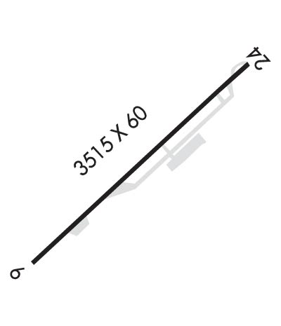
| Lat: N 3741.3 Long: W 08215.7 Elev: 1575 Var: +07 Longest Runway: 3515 | ||
| CTAF: 122.8 | ||
| ||||||||||||||||||||||||||||||||
| ||||||||||||||||||||||||||||||||
| Rwy | Rwy | |||||||
| 3515x60 | 3515' | 3515x60 | 3000' | |||||
| Runway ID | Single Wheel | Double Wheel | Double Tandem Wheel | Dual Double Wheel |
| These numbers are Advisory and are not limits. The Airport Manager should have more accurate Weight Limits | ||||
| FltPlan does not have IFR approach charts available for K4I0. |
 Airport Diagram might not be current. | |
| Facility Name: | MINGO COUNTY |
| City Name: | WILLIAMSON |
| County: | MINGO |
| State abbrev: | WV |
| State Name: | WEST VIRGINIA |
| Ownership: | PUBLICLY OWNED |
| Use: | OPEN TO THE PUBLIC |
| Owner's Name: | MINGO CO ARPT AUTHORITY |
| Address: | MINGO CO COURTHOUSE |
| WILLIAMSON, WV 25661 | |
| Owner's Phone: | 304-235-0376 |
| Manager's Name: | LEIGH ANN RAY |
| Address: | MINGO CO ARPT AUTHORITY, MINGO CO COURTHOUSE |
| WILLIAMSON, WV 25661 | |
| Phone: | (304) 234-0376; 304-235-4581 |
| FAA Region: | EASTERN |
| FAA Field Office: | BKW |
| Date | Sunrise | Sunset |
|---|---|---|
| 08/13/19 Tuesday | 6:43 | 20:25 |
| 08/14/19 Wednesday | 6:44 | 20:23 |
| 08/15/19 Thursday | 6:44 | 20:22 |
| 08/16/19 Friday | 6:45 | 20:21 |
| 08/17/19 Saturday | 6:46 | 20:19 |
| 08/18/19 Sunday | 6:47 | 20:18 |
| 08/19/19 Monday | 6:48 | 20:17 |
| 08/20/19 Tuesday | 6:49 | 20:16 |
| 08/21/19 Wednesday | 6:50 | 20:14 |
| 08/22/19 Thursday | 6:50 | 20:13 |
| 08/23/19 Friday | 6:51 | 20:11 |
| 08/24/19 Saturday | 6:52 | 20:10 |
| 08/25/19 Sunday | 6:53 | 20:09 |
| 08/26/19 Monday | 6:54 | 20:07 |
| Airport Attendance Schedule | UNATTENDED |
| Airport Status | OPERATIONAL (This Status can change at any time - please check NOTAMS) |
| Airport Lighting Schedule | |
| Airport Storage Available | Tie Downs |
| Extra Services Available | NONE |
| Wind Indicator | YES - (unlit) |
| Control Tower | NO |
| CTAF Frequency | 122.800 |
| Unicom Frequency | 122.800; UNICOM UNMON. |
| Rotating Beacon Color | |
| Segmented Circle | YES |
| Landing Fee | NO |
| Airport Inspected | STATE - performed by PRIVATE CONTRACT PERSONNEL |
| Inspection Date | 07/04/2017 |
| Type of Fuel Available | Grade 100LL |
| Airframe Repair Service | NONE |
| Power Plant Repair Service | NONE |
| Latitude | N3741.3 |
| Longitude | W08215.7 (ESTIMATED) |
| Arpt Elevation | 1575ft (SURVEYED) |
| Magnetic Variation | 07W |
| 1 miles NE | of WILLIAMSON |
| Traffic Pattern Altitude | |
| Sectional Chart | CINCINNATI |
| Operations (Reported) | Yearly | Avg. Daily |
|---|---|---|
| General Aviation Transient | 2000 | 5 |
| General Aviation Local | 2500 | 7 |
| Air Taxi | 0 | 0 |
| Commerical | 0 | 0 |
| Commuter | 0 | 0 |
| Military | 20 | 0 |
| Aircraft based on Field | |
|---|---|
| General Aviation Singles | 11 |
| General Aviation Multi | 0 |
| Jet Aircraft | 0 |
| General Aviation Helicopters | 0 |
| Military Aircraft | 0 |
| Gliders | 0 |
| Ultralights | 0 |
| FSS on field | NO |
| FSS tie-in | ELKINS |
| FSS Phone | 1-800-WX-BRIEF |
| Who issues Notams | EKN |
| Notam D service at airport | YES |
| ARTCC Name | INDIANAPOLIS |
| Airport Certification | |
| Aircraft Rescue & Firefighting Index | None |
| Airport of Entry | No |
| Custom Landing Rights | No |
| Joint Civil/Military | No |
| Military Landing rights | YES |
| NATIONAL PLAN OF INTEGRATED AIRPORT SYSTEMS (NPIAS) |
| GRANT AGREEMENTS UNDER FAAP/ADAP/AIP |
| ASSURANCES PURSUANT TO TITLE VI, CIVIL RIGHTS ACT OF 1964 |
| NO OPNS SUNSET-SUNRISE. |
| 304 FT AGL TWR ON HILL 1/4 MILE 'SE' OF RY. |
| 30 FT TREES, 15 FT FM RY EDGE. |
| RISING TERRAIN SURROUNDS ARPT. |
| FOR CD CTC INDIANAPOLIS ARTCC AT 317-247-2411. |
| Runway: 06 | Runway: 24 | ||
| Mag heading: | N/A | Mag heading: | N/A |
| Approach: | Approach: | ||
| Pattern: | Left Traffic | Pattern: | Left Traffic |
| Markings: | NONPRECISION INSTRUMENT | Markings: | NONPRECISION INSTRUMENT |
| Marking Condition: | POOR; RY MARKINGS FADED. | Marking Condition: | POOR; RY MARKINGS FADED. |
| Arresting Dev: | Arresting Dev: | ||
| Lat & Long: | Lat. & Long.: | ||
| Elev: | N/A | Elev: | N/A |
| TCH: | TCH: | ||
| Visual Glide Path: | Visual Glide Path: | ||
| Displaced Threshold: | No | Displaced Threshold: | 515 feet |
| Touchdown Zone: | NO | Touchdown Zone: | NO |
| Touchdown Elev.: | Touchdown Elev.: | ||
| Visual Glide Slope: | Visual Glide Slope: | ||
| RVR Equipment: | RVR Equipment: | ||
| RVV Equipment: | NO | RVV Equipment: | NO |
| Approach Lights: | Approach Lights: | ||
| REIL: | NO | REIL: | NO |
| Centerline Lights: | NO | Centerline Lights: | NO |
| Touchdown lights: | NO | Touchdown lights: | NO |
| Runway Category: | Runway with a Visual Approach | Runway Category: | Runway with a Visual Approach |
| Declared Distances: | Declared Distances: | ||
| Obstructions: | HILL | Obstructions: | HILL |
| Marked: | NOT Marked/Lighted | Marked: | NOT Marked/Lighted |
| Clearance slope: | Clearance slope: | APCH RATIO 0:1 AT DSPLCD THLD, 20 FT. TREES, 0 FT. DSTC, 62 FT. R. | |
| Obstruction height: | 70 feet AGL | Obstruction height: | 25 feet AGL |
| Dist. from runway: | 201 feet | Dist. from runway: | 201 feet |
| Centerline offset: | 120 right of centerline | Centerline offset: | 120 feet left of centerline |
| Comments: | 8 FT HILL, 0-200 FT DSTC, 120 FT R. | Comments: | 25 HILL, 0-201 FT FM THLD, 120 FT L. |
Thanks for using FltPlan.com
all rights reserved © 1999-2019 by Flight Plan LLC
