| MONROE COUNTY WOODSFIELD OH |
| |
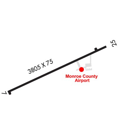
| Lat: N 3946.7 Long: W 08106.2 Elev: 1197 Var: +08 Longest Runway: 3805 | ||
| CTAF: 122.8 | ||
| |||||||||||||||||||||||
| |||||||||||||||||||||||
| Rwy | Rwy | |||||||
| 3805x75 | 3631' | 3805x75 | 3805' | |||||
| Runway ID | Single Wheel | Double Wheel | Double Tandem Wheel | Dual Double Wheel |
| 07/25 | 18,000 | N/A | N/A | N/A |
| These numbers are Advisory and are not limits. The Airport Manager should have more accurate Weight Limits | ||||
 Airport Diagram might not be current. | |
| Facility Name: | MONROE COUNTY |
| City Name: | WOODSFIELD |
| County: | MONROE |
| State abbrev: | OH |
| State Name: | OHIO |
| Ownership: | PUBLICLY OWNED |
| Use: | OPEN TO THE PUBLIC |
| Owner's Name: | MONROE COUNTY COMMISSIONERS |
| Address: | 101 N MAIN ST |
| WOODSFIELD, OH 43793-1070 | |
| Owner's Phone: | 740-472-1341 |
| Manager's Name: | DAVID DALRYMPLE |
| Address: | 47073 STATE ROUTE 26 |
| WOODSFIELD, OH 43793-9330 | |
| Phone: | 740-472-1882; CELL 740-213-3106. |
| FAA Region: | GREAT LAKES |
| FAA Field Office: | DET |
| Date | Sunrise | Sunset |
|---|---|---|
| 09/24/21 Friday | 7:14 | 19:19 |
| 09/25/21 Saturday | 7:15 | 19:17 |
| 09/26/21 Sunday | 7:16 | 19:15 |
| 09/27/21 Monday | 7:16 | 19:14 |
| 09/28/21 Tuesday | 7:17 | 19:12 |
| 09/29/21 Wednesday | 7:18 | 19:10 |
| 09/30/21 Thursday | 7:19 | 19:09 |
| 10/01/21 Friday | 7:20 | 19:07 |
| 10/02/21 Saturday | 7:21 | 19:06 |
| 10/03/21 Sunday | 7:22 | 19:04 |
| 10/04/21 Monday | 7:23 | 19:02 |
| 10/05/21 Tuesday | 7:24 | 19:01 |
| 10/06/21 Wednesday | 7:25 | 18:59 |
| 10/07/21 Thursday | 7:26 | 18:58 |
| Airport Attendance Schedule | IRREGULAR |
| Airport Status | OPERATIONAL (This Status can change at any time - please check NOTAMS) |
| Airport Lighting Schedule | ACTVT REIL RWY 25; MIRL RWY 07/25 - CTAF. |
| Airport Storage Available | Tie Downs |
| Extra Services Available | NONE |
| Wind Indicator | YES - (lighted) |
| Control Tower | NO |
| CTAF Frequency | 122.800 |
| Unicom Frequency | 122.800 |
| Rotating Beacon Color | CLEAR-GREEN (Light Land Airport) |
| Segmented Circle | NO |
| Landing Fee | NO |
| Airport Inspected | STATE - performed by STATE AERONAUTICAL PERSONNEL |
| Inspection Date | 06/30/2021 |
| Type of Fuel Available | Grade 100LL, JET A; -10FULL SER ONLY CALL AMGR CELL. |
| Airframe Repair Service | NONE |
| Power Plant Repair Service | NONE |
| Latitude | N3946.7 |
| Longitude | W08106.2 (ESTIMATED) |
| Arpt Elevation | 1197ft (SURVEYED) |
| Magnetic Variation | 08W |
| 1 miles N | of WOODSFIELD |
| Traffic Pattern Altitude | |
| Sectional Chart | CINCINNATI |
| Operations (Reported) | Yearly | Avg. Daily |
|---|---|---|
| General Aviation Transient | 860 | 2 |
| General Aviation Local | 100 | 0 |
| Air Taxi | 10 | 0 |
| Commerical | 0 | 0 |
| Commuter | 0 | 0 |
| Military | 54 | 0 |
| Aircraft based on Field | |
|---|---|
| General Aviation Singles | 8 |
| General Aviation Multi | 0 |
| Jet Aircraft | 0 |
| General Aviation Helicopters | 3 |
| Military Aircraft | 0 |
| Gliders | 0 |
| Ultralights | 0 |
| FSS on field | NO |
| FSS tie-in | CLEVELAND |
| FSS Phone | 1-800-WX-BRIEF |
| Who issues Notams | CLE |
| Notam D service at airport | YES |
| ARTCC Name | CLEVELAND |
| Airport Certification | |
| Aircraft Rescue & Firefighting Index | None |
| Airport of Entry | No |
| Custom Landing Rights | No |
| Joint Civil/Military | No |
| Military Landing rights | No |
| NATIONAL PLAN OF INTEGRATED AIRPORT SYSTEMS (NPIAS) |
| OCNL DEER, BIRDS, & OTR WILDLIFE ON & INVOF ARPT. |
| FOR CD CTC CLEVELAND ARTCC AT 440-774-0226. |
Airport Communications & Frequencies:
| |||||||||
| Runway: 07 | Runway: 25 | ||
| Mag heading: | 74° | Mag heading: | 254° |
| Rwy Slope: | -.08% Down | Rwy Slope: | .08% Up |
| Approach: | Approach: | ||
| Pattern: | Left Traffic | Pattern: | Left Traffic |
| Markings: | NONPRECISION INSTRUMENT | Markings: | NONPRECISION INSTRUMENT |
| Marking Condition: | GOOD | Marking Condition: | GOOD |
| Arresting Dev: | Arresting Dev: | ||
| Lat & Long: | N3946.6 W08106.5 | Lat. & Long.: | N3946.9 W08105.8 |
| Elev: | 1193.9 ft. MSL | Elev: | 1190.7 ft. MSL |
| TCH: | TCH: | ||
| Visual Glide Path: | Visual Glide Path: | ||
| Displaced Threshold: | 174 feet | Displaced Threshold: | No |
| Touchdown Zone: | YES | Touchdown Zone: | YES |
| Touchdown Elev.: | 1197.1 feet | Touchdown Elev.: | 1197.1 feet |
| Visual Glide Slope: | Visual Glide Slope: | ||
| RVR Equipment: | RVR Equipment: | ||
| RVV Equipment: | NO | RVV Equipment: | NO |
| Approach Lights: | Approach Lights: | ||
| REIL: | NO | REIL: | YES |
| Centerline Lights: | NO | Centerline Lights: | NO |
| Touchdown lights: | NO | Touchdown lights: | NO |
| Runway Category: | Runway with a Visual Approach | Runway Category: | Runway with a Non-precision Approach |
| Declared Distances: | Declared Distances: | ||
| Obstructions: | TREES | Obstructions: | TREES |
| Marked: | NOT Marked/Lighted | Marked: | NOT Marked/Lighted |
| Clearance slope: | 9:1; APCH RATIO 17:1 TO DTHR. | Clearance slope: | |
| Obstruction height: | 140 feet AGL | Obstruction height: | 23 feet AGL |
| Dist. from runway: | 1582 feet | Dist. from runway: | 238 feet |
| Centerline offset: | 260 right of centerline | Centerline offset: | 140 feet left of centerline |
| Comments: | Comments: | 0-15 FT TREES & BRUSH, 0-200 FT DIST, 135-210 FT L. |
Thanks for using FltPlan.com
all rights reserved © 1999-2021 by Flight Plan LLC