
| YOUNGSTOWN ELSER METRO YOUNGSTOWN OH |
| |
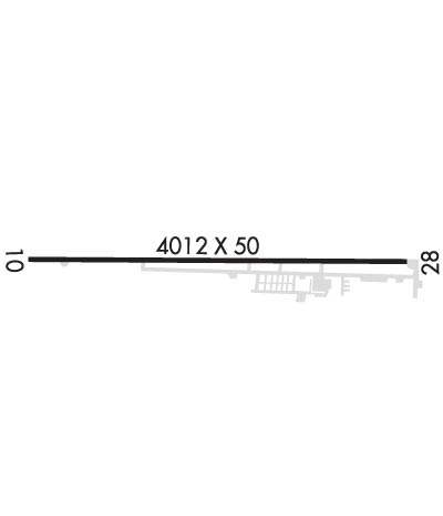
| Lat: N 4057.7 Long: W 08040.6 Elev: 1070 Var: +08 Longest Runway: 4012 | ||
| Clr Del: 119.25 CTAF: 123.05 | ||
| ||||||
|
| Rwy | Rwy | |||||||
| 4012x50 | 3664' | 4012x50 | 3753' | |||||
| Runway ID | Single Wheel | Double Wheel | Double Tandem Wheel | Dual Double Wheel |
| 10/28 | N/A | N/A | N/A | N/A |
| These numbers are Advisory and are not limits. The Airport Manager should have more accurate Weight Limits | ||||
 Airport Diagram might not be current. | |
| Facility Name: | YOUNGSTOWN ELSER METRO |
| City Name: | YOUNGSTOWN |
| County: | MAHONING |
| State abbrev: | OH |
| State Name: | OHIO |
| Ownership: | PRIVATELY OWNED |
| Use: | OPEN TO THE PUBLIC |
| Owner's Name: | MICHAEL E. STANKO |
| Address: | 8491 IVY HILL DR |
| POLAND, OH 44514 | |
| Owner's Phone: | (330) 757-1147 |
| Manager's Name: | MICHAEL E. STANKO |
| Address: | 10800 SHARROTT RD |
| NORTH LIMA, OH 44452 | |
| Phone: | 330-549-0337 |
| FAA Region: | GREAT LAKES |
| FAA Field Office: | DET |
| Date | Sunrise | Sunset |
|---|---|---|
| 09/24/21 Friday | 7:12 | 19:17 |
| 09/25/21 Saturday | 7:13 | 19:15 |
| 09/26/21 Sunday | 7:14 | 19:13 |
| 09/27/21 Monday | 7:15 | 19:12 |
| 09/28/21 Tuesday | 7:16 | 19:10 |
| 09/29/21 Wednesday | 7:17 | 19:08 |
| 09/30/21 Thursday | 7:18 | 19:07 |
| 10/01/21 Friday | 7:19 | 19:05 |
| 10/02/21 Saturday | 7:20 | 19:03 |
| 10/03/21 Sunday | 7:21 | 19:02 |
| 10/04/21 Monday | 7:22 | 19:00 |
| 10/05/21 Tuesday | 7:23 | 18:58 |
| 10/06/21 Wednesday | 7:24 | 18:57 |
| 10/07/21 Thursday | 7:25 | 18:55 |
| Airport Attendance Schedule | 7 Days A Week 0730-1800; UNATNDD EASTER, THANKSGIVING, CHRISTMAS. |
| Airport Status | OPERATIONAL (This Status can change at any time - please check NOTAMS) |
| Airport Lighting Schedule | |
| Airport Storage Available | Hanger |
| Extra Services Available | Air Ambulance, Flight Instruction, Aircraft Rental, Aircraft Sales |
| Wind Indicator | YES - (unlit) |
| Control Tower | NO |
| CTAF Frequency | 123.050 |
| Unicom Frequency | 123.050 |
| Rotating Beacon Color | CLEAR-GREEN (Light Land Airport) |
| Segmented Circle | NO |
| Landing Fee | NO |
| Airport Inspected | STATE - performed by PRIVATE CONTRACT PERSONNEL |
| Inspection Date | 09/27/2018 |
| Type of Fuel Available | Grade 100LL, JET A (freeze point -40C) |
| Airframe Repair Service | MAJOR |
| Power Plant Repair Service | MAJOR |
| Latitude | N4057.7 |
| Longitude | W08040.6 (ESTIMATED) |
| Arpt Elevation | 1069ft (SURVEYED) |
| Magnetic Variation | 08W |
| 7 miles SW | of YOUNGSTOWN |
| Traffic Pattern Altitude | |
| Sectional Chart | DETROIT |
| Operations (Reported) | Yearly | Avg. Daily |
|---|---|---|
| General Aviation Transient | 1200 | 3 |
| General Aviation Local | 8000 | 22 |
| Air Taxi | 218 | 1 |
| Commerical | 0 | 0 |
| Commuter | 0 | 0 |
| Military | 100 | 0 |
| Aircraft based on Field | |
|---|---|
| General Aviation Singles | 46 |
| General Aviation Multi | 5 |
| Jet Aircraft | 1 |
| General Aviation Helicopters | 20 |
| Military Aircraft | 0 |
| Gliders | 0 |
| Ultralights | 0 |
| FSS on field | NO |
| FSS tie-in | CLEVELAND |
| FSS Phone | 1-800-WX-BRIEF |
| Who issues Notams | CLE |
| Notam D service at airport | YES |
| ARTCC Name | CLEVELAND |
| Airport Certification | |
| Aircraft Rescue & Firefighting Index | None |
| Airport of Entry | No |
| Custom Landing Rights | No |
| Joint Civil/Military | No |
| Military Landing rights | No |
| TWR 1085'AGL /2118'MSL/ LCTD 7-1/2 NM NNE. |
| FOR APCH/DEP SVC WHEN CLEVELAND APCH UNAVBL. CTC CLEVELAND ARTCC AT 440-774-0223. |
| FOR CD CTC CLEVELAND APCH AT 216-352-2323., FOR CD WHEN CLEVELAND APCH UNAVBL, CTC CLEVELAND ARTCC AT 440-774-0490. |
Airport Communications & Frequencies:
| |||||||||||||||||||
| Runway: 10 | Runway: 28 | ||
| Mag heading: | 98° | Mag heading: | 278° |
| Rwy Slope: | 1.44% Up | Rwy Slope: | -1.44% Down |
| Approach: | Approach: | ||
| Pattern: | Left Traffic | Pattern: | Left Traffic |
| Markings: | NONPRECISION INSTRUMENT | Markings: | NONPRECISION INSTRUMENT |
| Marking Condition: | GOOD | Marking Condition: | GOOD |
| Arresting Dev: | Arresting Dev: | ||
| Lat & Long: | N4057.7 W08041.1 | Lat. & Long.: | N4057.7 W08040.2 |
| Elev: | 1012.0 ft. MSL | Elev: | 1069.6 ft. MSL |
| TCH: | TCH: | ||
| Visual Glide Path: | 3.00 degrees | Visual Glide Path: | 3.75 degrees |
| Displaced Threshold: | 348 feet | Displaced Threshold: | 259 feet |
| Touchdown Zone: | YES | Touchdown Zone: | YES |
| Touchdown Elev.: | 1050.5 feet | Touchdown Elev.: | 1063.3 feet |
| Visual Glide Slope: | 2-Light PAPI on LEFT side of Runway | Visual Glide Slope: | 2-Light PAPI on LEFT side of Runway |
| RVR Equipment: | RVR Equipment: | ||
| RVV Equipment: | NO | RVV Equipment: | NO |
| Approach Lights: | Approach Lights: | ||
| REIL: | YES | REIL: | YES |
| Centerline Lights: | NO | Centerline Lights: | NO |
| Touchdown lights: | NO | Touchdown lights: | NO |
| Runway Category: | Runway with a Non-precision Approach | Runway Category: | Runway with a Non-precision Approach |
| Declared Distances: | Declared Distances: | ||
| Obstructions: | TREES | Obstructions: | TREES |
| Marked: | NOT Marked/Lighted | Marked: | NOT Marked/Lighted |
| Clearance slope: | RWY 10 APCH RATIO 0:1 TO DSPLCD THLD DUE TO +73 FT TREES 0 FT FM THLD 124 FT R. | Clearance slope: | APCH RATIO 0:1 TO DSPLCD THLD DUE TO +20 FT POWER LINE 0 FT FM DSPLCD THLD 177 FT R. |
| Obstruction height: | 70 feet AGL | Obstruction height: | 70 feet AGL |
| Dist. from runway: | 201 feet | Dist. from runway: | 201 feet |
| Centerline offset: | 130 right of centerline | Centerline offset: | 214 feet right of centerline |
| Comments: | 71 FT TREES 0 FT DSTC 125 FT L. | Comments: | 18 FT ROAD 163 FT TO 200 FT DSTC, 0 FT B; 5 FT FENCE 140 FT DSTC, 0 FT B; +25 FT HGR 45 FT-100 FT DSTC, 207 FT L. |
Thanks for using FltPlan.com
all rights reserved © 1999-2021 by Flight Plan LLC
