
| MILLER ALLIANCE OH |
| |
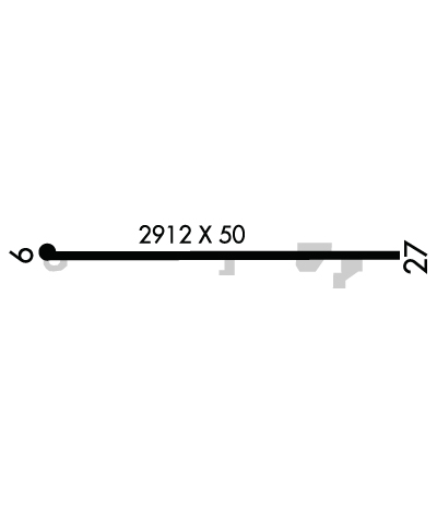
| Lat: N 4058.9 Long: W 08102.5 Elev: 1071 Var: +04 Longest Runway: 2912 | ||
| CTAF: 122.9 | ||
| |||||
|
| Rwy | Rwy | |||||||
| 2912x50 | 2912' | 2912x50 | 2912' | |||||
| Runway ID | Single Wheel | Double Wheel | Double Tandem Wheel | Dual Double Wheel |
| 09/27 | 9,000 | N/A | N/A | N/A |
| These numbers are Advisory and are not limits. The Airport Manager should have more accurate Weight Limits | ||||
| FltPlan does not have IFR approach charts available for K4G3. |
 Airport Diagram might not be current. | |
| Facility Name: | MILLER |
| City Name: | ALLIANCE |
| County: | MAHONING |
| State abbrev: | OH |
| State Name: | OHIO |
| Ownership: | PRIVATELY OWNED |
| Use: | OPEN TO THE PUBLIC |
| Owner's Name: | GROVER MATTHEWS |
| Address: | 1286 ADAMS ST |
| FAIRBORN, OH 45324-5505 | |
| Owner's Phone: | 270-863-1799 |
| Manager's Name: | GROVER MATTHEWS; GCMLLM1963@GMAIL.COM. |
| Address: | 1286 ADAMS ST; ARPT PHYS ADS: 20388 N BENTON WEST RD, NORTH BENTON, OH 44449-9636. |
| FAIRBORN, OH 45324-5505 | |
| Phone: | 270-863-1799 |
| FAA Region: | GREAT LAKES |
| FAA Field Office: | DET |
| Date | Sunrise | Sunset |
|---|---|---|
| 06/12/26 Friday | 5:52 | 20:57 |
| 06/13/26 Saturday | 5:51 | 20:57 |
| 06/14/26 Sunday | 5:51 | 20:57 |
| 06/15/26 Monday | 5:51 | 20:58 |
| 06/16/26 Tuesday | 5:51 | 20:58 |
| 06/17/26 Wednesday | 5:52 | 20:59 |
| 06/18/26 Thursday | 5:52 | 20:59 |
| 06/19/26 Friday | 5:52 | 20:59 |
| 06/20/26 Saturday | 5:52 | 20:59 |
| 06/21/26 Sunday | 5:52 | 21:00 |
| 06/22/26 Monday | 5:52 | 21:00 |
| 06/23/26 Tuesday | 5:53 | 21:00 |
| 06/24/26 Wednesday | 5:53 | 21:00 |
| 06/25/26 Thursday | 5:53 | 21:00 |
| Airport Attendance Schedule | UNATTENDED; CTC AMGR 48 HRS PRIOR TO VFY FLD CONDS. |
| Airport Status | CLOSED INDEFINITELY (This Status can change at any time - please check NOTAMS) |
| Airport Lighting Schedule | |
| Airport Storage Available | Tie Downs |
| Extra Services Available | NONE |
| Wind Indicator | YES - (unlit) |
| Control Tower | NO |
| CTAF Frequency | 122.900 |
| Unicom Frequency | |
| Rotating Beacon Color | WG |
| Segmented Circle | NO |
| Landing Fee | NO |
| Airport Inspected | CONTRACTOR - performed by STATE AERONAUTICAL PERSONNEL |
| Inspection Date | 09/17/2024 |
| Type of Fuel Available | None |
| Airframe Repair Service | None |
| Power Plant Repair Service | None |
| Latitude | N4058.9 |
| Longitude | W08102.5 (ESTIMATED) |
| Arpt Elevation | 1071ft (SURVEYED) |
| Magnetic Variation | 04W |
| 5 miles NE | of ALLIANCE |
| Traffic Pattern Altitude | |
| Sectional Chart | DETROIT |
| Operations (Reported) | Yearly | Avg. Daily |
|---|---|---|
| General Aviation Transient | 0 | 0 |
| General Aviation Local | 0 | 0 |
| Air Taxi | 0 | 0 |
| Commerical | 0 | 0 |
| Commuter | 0 | 0 |
| Military | 0 | 0 |
| Aircraft based on Field | |
|---|---|
| General Aviation Singles | 0 |
| General Aviation Multi | 0 |
| Jet Aircraft | 0 |
| General Aviation Helicopters | 0 |
| Military Aircraft | 0 |
| Gliders | 0 |
| Ultralights | 0 |
| FSS on field | NO |
| FSS tie-in | CLEVELAND |
| FSS Phone | 1-800-WX-BRIEF |
| Who issues Notams | CLE |
| Notam D service at airport | YES |
| ARTCC Name | CLEVELAND |
| Airport Certification | |
| Aircraft Rescue & Firefighting Index | None |
| Airport of Entry | No |
| Custom Landing Rights | No |
| Joint Civil/Military | No |
| Military Landing rights | No |
| THIS AIRPORT HAS BEEN SURVEYED BY THE NATIONAL GEODETIC SURVEY. |
| DAYTIME OPS ONLY. |
| FOR CD CTC CLEVELAND APCH AT 216-352-2323, WHEN APCH CLSD CTC CLEVELAND ARTCC AT 440-774-0223/0490. |
| DEER, BIRDS, & WILDLIFE ON & INVOF ARPT. |
| (ARPT STATUS) ARPT CLSD INDEFLY. |
Airport Communications & Frequencies:
| |||||||||||||||
| Runway: 09 | Runway: 27 | ||
| Mag heading: | 95° | Mag heading: | 275° |
| Rwy Slope: | .37% Up | Rwy Slope: | -.37% Down |
| Approach: | Approach: | ||
| Pattern: | Left Traffic | Pattern: | Left Traffic |
| Markings: | BASIC | Markings: | BASIC |
| Marking Condition: | POOR; FADED. | Marking Condition: | POOR; FADED. |
| Arresting Dev: | Arresting Dev: | ||
| Lat & Long: | N4058.9 W08102.8 | Lat. & Long.: | N4058.9 W08102.2 |
| Elev: | 1056.4 ft. MSL | Elev: | 1067.1 ft. MSL |
| TCH: | TCH: | ||
| Visual Glide Path: | Visual Glide Path: | ||
| Displaced Threshold: | No | Displaced Threshold: | No |
| Touchdown Zone: | YES | Touchdown Zone: | YES |
| Touchdown Elev.: | 1071.1 feet | Touchdown Elev.: | 1071.1 feet |
| Visual Glide Slope: | Visual Glide Slope: | ||
| RVR Equipment: | RVR Equipment: | ||
| RVV Equipment: | NO | RVV Equipment: | NO |
| Approach Lights: | Approach Lights: | ||
| REIL: | NO | REIL: | NO |
| Centerline Lights: | NO | Centerline Lights: | NO |
| Touchdown lights: | NO | Touchdown lights: | NO |
| Runway Category: | Runway with a Visual Approach | Runway Category: | Runway with a Visual Approach |
| Declared Distances: | Declared Distances: | ||
| Obstructions: | TREES | Obstructions: | TREES |
| Marked: | NOT Marked/Lighted | Marked: | NOT Marked/Lighted |
| Clearance slope: | 7:1; +35 FT TREES, 201 FT DIST, 120 FT R. | Clearance slope: | |
| Obstruction height: | 110 feet AGL | Obstruction height: | 35 feet AGL |
| Dist. from runway: | 1000 feet | Dist. from runway: | 201 feet |
| Centerline offset: | 165 right of centerline | Centerline offset: | 120 feet right of centerline |
| Comments: | 8 FT CROPS, 60 FT DIST, 125 FT L/R; 65 FT TREES, 0-55 FT DIST, 110 FT R; 35 FT TREE, 55 FT DIST, 125 FT L. | Comments: | 60 FT TREES, 132 FT DIST, 120 FT R. |
Thanks for using FltPlan.com
all rights reserved © 1999-2026 by Flight Plan LLC
