
| LA MOURE ROTT MUNI LA MOURE ND |
| |
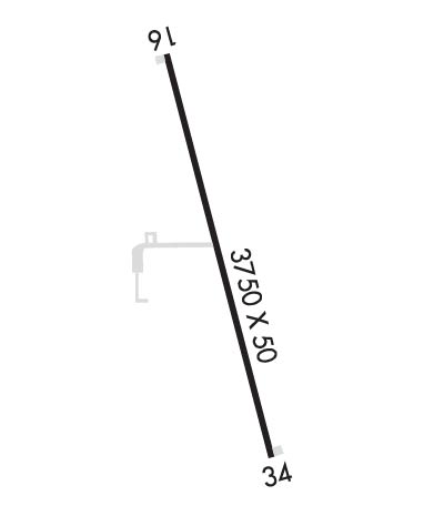
| Lat: N 4620.8 Long: W 09816.9 Elev: 1310 Var: -07 Longest Runway: 3400 | ||
| CTAF: 122.9 | ||
| ||||||||||||||||||||||||||||||||
| ||||||||||||||||||||||||||||||||
| Rwy | Rwy | |||||||
| 3400x50 | 3400' | 3400x50 | 3400' | |||||
| Runway ID | Single Wheel | Double Wheel | Double Tandem Wheel | Dual Double Wheel |
| 16/34 | N/A | N/A | N/A | N/A |
| These numbers are Advisory and are not limits. The Airport Manager should have more accurate Weight Limits | ||||
| FltPlan does not have IFR approach charts available for K4F9. |
 Airport Diagram might not be current. | |
| Facility Name: | LA MOURE ROTT MUNI |
| City Name: | LA MOURE |
| County: | LA MOURE |
| State abbrev: | ND |
| State Name: | NORTH DAKOTA |
| Ownership: | PRIVATELY OWNED |
| Use: | OPEN TO THE PUBLIC |
| Owner's Name: | JAMES BITZ |
| Address: | 7381 COUNTY ROAD 60 |
| LAMOURE, ND 58458 | |
| Owner's Phone: | 701-883-5968 |
| Manager's Name: | BLANE ROBERT |
| Address: | 7357 COUNTY ROAD 60 |
| LAMOURE, ND 58458 | |
| Phone: | 701-883-5047; AMGR ALT CTC (701) 320-4189. |
| FAA Region: | GREAT LAKES |
| FAA Field Office: | DMA |
| Date | Sunrise | Sunset |
|---|---|---|
| 09/24/21 Friday | 7:22 | 19:27 |
| 09/25/21 Saturday | 7:24 | 19:25 |
| 09/26/21 Sunday | 7:25 | 19:23 |
| 09/27/21 Monday | 7:26 | 19:21 |
| 09/28/21 Tuesday | 7:27 | 19:19 |
| 09/29/21 Wednesday | 7:29 | 19:17 |
| 09/30/21 Thursday | 7:30 | 19:15 |
| 10/01/21 Friday | 7:31 | 19:13 |
| 10/02/21 Saturday | 7:33 | 19:11 |
| 10/03/21 Sunday | 7:34 | 19:10 |
| 10/04/21 Monday | 7:35 | 19:08 |
| 10/05/21 Tuesday | 7:37 | 19:06 |
| 10/06/21 Wednesday | 7:38 | 19:04 |
| 10/07/21 Thursday | 7:39 | 19:02 |
| Airport Attendance Schedule | OCT-APR 7 Days A Week ON CALL, MAY-SEP 7 Days A Week ON CALL |
| Airport Status | OPERATIONAL (This Status can change at any time - please check NOTAMS) |
| Airport Lighting Schedule | ACTVT NSTD LIRL RWY 16/34 - CTAF. |
| Airport Storage Available | Tie Downs |
| Extra Services Available | Crop Dusting |
| Wind Indicator | YES - (lighted) |
| Control Tower | NO |
| CTAF Frequency | 122.900 |
| Unicom Frequency | |
| Rotating Beacon Color | |
| Segmented Circle | NO |
| Landing Fee | NO |
| Airport Inspected | STATE - performed by STATE AERONAUTICAL PERSONNEL |
| Inspection Date | 09/23/2020 |
| Type of Fuel Available | None |
| Airframe Repair Service | NONE |
| Power Plant Repair Service | NONE |
| Latitude | N4620.8 |
| Longitude | W09816.9 (ESTIMATED) |
| Arpt Elevation | 1310ft (ESTIMATED) |
| Magnetic Variation | 07E |
| 1 miles SE | of LA MOURE |
| Traffic Pattern Altitude | |
| Sectional Chart | TWIN CITIES |
| Operations (Reported) | Yearly | Avg. Daily |
|---|---|---|
| General Aviation Transient | 800 | 2 |
| General Aviation Local | 2600 | 7 |
| Air Taxi | 100 | 0 |
| Commerical | 0 | 0 |
| Commuter | 0 | 0 |
| Military | 50 | 0 |
| Aircraft based on Field | |
|---|---|
| General Aviation Singles | 3 |
| General Aviation Multi | 1 |
| Jet Aircraft | 0 |
| General Aviation Helicopters | 0 |
| Military Aircraft | 0 |
| Gliders | 0 |
| Ultralights | 0 |
| FSS on field | NO |
| FSS tie-in | GRAND FORKS |
| FSS Phone | 1-800-WX-BRIEF |
| Who issues Notams | GFK |
| Notam D service at airport | YES |
| ARTCC Name | MINNEAPOLIS |
| Airport Certification | |
| Aircraft Rescue & Firefighting Index | None |
| Airport of Entry | No |
| Custom Landing Rights | No |
| Joint Civil/Military | No |
| Military Landing rights | No |
| NATIONAL PLAN OF INTEGRATED AIRPORT SYSTEMS (NPIAS) |
| IRRIGATION SPRINKLER PIVOT SYSTEM 160 FT E CNTRLN RWY 16/34 AT 14 FT AGL VIOLATES 7:1 TRANS SFC. |
| CONFIRM WINTER CONDITION & SNOW REMOVAL WITH AMGR. |
| DEER & BIRDS INVOF ARPT |
| FOR CD CTC MINNEAPOLIS ARTCC AT 651-463-5588. |
| RWY 16/3 4 RWY 16/34 NSTD LOW INTENSITY LGTS. |
| Runway: 16 | Runway: 34 | ||
| Mag heading: | 158° | Mag heading: | 338° |
| Rwy Slope: | -.08% Down | Rwy Slope: | .08% Up |
| Approach: | Approach: | ||
| Pattern: | Left Traffic | Pattern: | Left Traffic |
| Markings: | BASIC | Markings: | BASIC |
| Marking Condition: | GOOD | Marking Condition: | GOOD |
| Arresting Dev: | Arresting Dev: | ||
| Lat & Long: | N4621.1 W09817.0 | Lat. & Long.: | N4620.6 W09816.8 |
| Elev: | 1308.7 ft. MSL | Elev: | 1306.1 ft. MSL |
| TCH: | TCH: | ||
| Visual Glide Path: | Visual Glide Path: | ||
| Displaced Threshold: | No | Displaced Threshold: | No |
| Touchdown Zone: | NO | Touchdown Zone: | NO |
| Touchdown Elev.: | Touchdown Elev.: | ||
| Visual Glide Slope: | Visual Glide Slope: | ||
| RVR Equipment: | RVR Equipment: | ||
| RVV Equipment: | NO | RVV Equipment: | NO |
| Approach Lights: | Approach Lights: | ||
| REIL: | NO | REIL: | NO |
| Centerline Lights: | NO | Centerline Lights: | NO |
| Touchdown lights: | NO | Touchdown lights: | NO |
| Runway Category: | Runway with a Visual Approach | Runway Category: | Runway with a Visual Approach |
| Declared Distances: | Declared Distances: | ||
| Obstructions: | POLE; 14 FT AGL MOBILE IRRIGATOR E OF RWY 5:1 CLNC SLOPE. | Obstructions: | POLE |
| Marked: | NOT Marked/Lighted | Marked: | NOT Marked/Lighted |
| Clearance slope: | 5:1 | Clearance slope: | 18:1 |
| Obstruction height: | 14 feet AGL | Obstruction height: | 12 feet AGL |
| Dist. from runway: | 270 feet | Dist. from runway: | 420 feet |
| Centerline offset: | 130 left of centerline | Centerline offset: | 135 feet left of centerline |
| Comments: | Comments: |
Thanks for using FltPlan.com
all rights reserved © 1999-2021 by Flight Plan LLC
