
| POLK COUNTY-CORNELIUS-MOORE CEDARTOWN GA |
| |
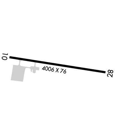
| Lat: N 3401.1 Long: W 08508.7 Elev: 974 Var: +05 Longest Runway: 5060 | ||
| CTAF: 122.8 | ||
| ||||||||||||||||||||||||||||||||||||||||||||
| ||||||||||||||||||||||||||||||||||||||||||||
| Rwy | Rwy | |||||||
| 5060x75 | 5060' | 5060x75 | 5060' | |||||
| Runway ID | Single Wheel | Double Wheel | Double Tandem Wheel | Dual Double Wheel |
| 10/28 | 20,000 | N/A | N/A | N/A |
| These numbers are Advisory and are not limits. The Airport Manager should have more accurate Weight Limits | ||||
 Airport Diagram might not be current. | |
| Facility Name: | POLK COUNTY/CORNELIUS MOORE FLD |
| City Name: | CEDARTOWN |
| County: | POLK |
| State abbrev: | GA |
| State Name: | GEORGIA |
| Ownership: | PUBLICLY OWNED |
| Use: | OPEN TO THE PUBLIC |
| Owner's Name: | POLK COUNTY |
| Address: | 216 MAIN ST |
| CEDARTOWN, GA 30125 | |
| Owner's Phone: | 770-749-2100 |
| Manager's Name: | CHUCK BEAVERS |
| Address: | 500 AIRPORT ROAD, 144 WEST AVE |
| CEDARTOWN, GA 30125 | |
| Phone: | 770-684-7136; FBO 770-684-7136. |
| FAA Region: | SOUTHERN |
| FAA Field Office: | ATL |
| Date | Sunrise | Sunset |
|---|---|---|
| 06/08/26 Monday | 6:29 | 20:50 |
| 06/09/26 Tuesday | 6:29 | 20:51 |
| 06/10/26 Wednesday | 6:29 | 20:51 |
| 06/11/26 Thursday | 6:29 | 20:52 |
| 06/12/26 Friday | 6:29 | 20:52 |
| 06/13/26 Saturday | 6:29 | 20:53 |
| 06/14/26 Sunday | 6:29 | 20:53 |
| 06/15/26 Monday | 6:29 | 20:53 |
| 06/16/26 Tuesday | 6:29 | 20:54 |
| 06/17/26 Wednesday | 6:29 | 20:54 |
| 06/18/26 Thursday | 6:29 | 20:54 |
| 06/19/26 Friday | 6:29 | 20:55 |
| 06/20/26 Saturday | 6:29 | 20:55 |
| 06/21/26 Sunday | 6:30 | 20:55 |
| Airport Attendance Schedule | 7 Days A Week 0900-1700 |
| Airport Status | OPERATIONAL (This Status can change at any time - please check NOTAMS) |
| Airport Lighting Schedule | ACTVT PAPI RWY 10 & 28; MIRL RWY 10/28 - CTAF. |
| Airport Storage Available | Tie Downs |
| Extra Services Available | Parachute Jumping |
| Wind Indicator | NONE |
| Control Tower | NO |
| CTAF Frequency | 122.800 |
| Unicom Frequency | 122.800 |
| Rotating Beacon Color | WG |
| Segmented Circle | YES |
| Landing Fee | NO |
| Airport Inspected | STATE - performed by STATE AERONAUTICAL PERSONNEL |
| Inspection Date | 04/25/2025 |
| Type of Fuel Available | Grade 100LL, JET A (freeze point -40C) |
| Airframe Repair Service | NONE |
| Power Plant Repair Service | NONE |
| Latitude | N3401.1 |
| Longitude | W08508.7 (ESTIMATED) |
| Arpt Elevation | 973ft (SURVEYED) |
| Magnetic Variation | 05W |
| 5 miles E | of CEDARTOWN |
| Traffic Pattern Altitude | |
| Sectional Chart | ATLANTA |
| Operations (Reported) | Yearly | Avg. Daily |
|---|---|---|
| General Aviation Transient | 0 | 0 |
| General Aviation Local | 0 | 0 |
| Air Taxi | 0 | 0 |
| Commerical | 0 | 0 |
| Commuter | 0 | 0 |
| Military | 0 | 0 |
| Aircraft based on Field | |
|---|---|
| General Aviation Singles | 0 |
| General Aviation Multi | 0 |
| Jet Aircraft | 0 |
| General Aviation Helicopters | 0 |
| Military Aircraft | 0 |
| Gliders | 0 |
| Ultralights | 0 |
| FSS on field | NO |
| FSS tie-in | MACON |
| FSS Phone | 1-800-WX-BRIEF |
| Who issues Notams | MCN |
| Notam D service at airport | YES |
| ARTCC Name | ATLANTA |
| Airport Certification | |
| Aircraft Rescue & Firefighting Index | None |
| Airport of Entry | No |
| Custom Landing Rights | No |
| Joint Civil/Military | No |
| Military Landing rights | YES |
| NATIONAL PLAN OF INTEGRATED AIRPORT SYSTEMS (NPIAS) |
| GRANT AGREEMENTS UNDER FAAP/ADAP/AIP |
| ASSURANCES PURSUANT TO TITLE VI, CIVIL RIGHTS ACT OF 1964 |
| DEER & BIRDS ON & INVOF OF ARPT. |
| EXTENSIVE PARACHUTE ACTIVITY ON WEEKENDS - AVOID OVERFLIGHTS OF ARPT. |
| FOR CD CTC ATLANTA ARTCC AT 770-210-7692. |
| MNT CTAF FREQ AND FRQLY BCST LCTN AND INTNS FOR RWY USE DUE TO NO LINE OF SIGHT BTN RWY ENDS. |
| RWY 10 IS THE PREFERRED DEP RWY DURG CALM WINDS. |
Airport Communications & Frequencies:
| |||||||||
| Runway: 10 | Runway: 28 | ||
| Mag heading: | 102° | Mag heading: | 282° |
| Rwy Slope: | -.65% Down | Rwy Slope: | .65% Up |
| Approach: | Approach: | ||
| Pattern: | Left Traffic | Pattern: | Left Traffic |
| Markings: | NONPRECISION INSTRUMENT | Markings: | NONPRECISION INSTRUMENT |
| Marking Condition: | GOOD | Marking Condition: | GOOD |
| Arresting Dev: | Arresting Dev: | ||
| Lat & Long: | N3401.2 W08509.2 | Lat. & Long.: | N3401.1 W08508.2 |
| Elev: | 971.2 ft. MSL | Elev: | 938.1 ft. MSL |
| TCH: | 41 ft. AGL | TCH: | 43 ft. AGL |
| Visual Glide Path: | 3.00 degrees | Visual Glide Path: | 3.00 degrees |
| Displaced Threshold: | No | Displaced Threshold: | No |
| Touchdown Zone: | YES | Touchdown Zone: | YES |
| Touchdown Elev.: | 973.7 feet | Touchdown Elev.: | 968.5 feet |
| Visual Glide Slope: | 2-Light PAPI on LEFT side of Runway | Visual Glide Slope: | 2-Light PAPI on LEFT side of Runway |
| RVR Equipment: | RVR Equipment: | ||
| RVV Equipment: | NO | RVV Equipment: | NO |
| Approach Lights: | Approach Lights: | ||
| REIL: | NO | REIL: | NO |
| Centerline Lights: | NO | Centerline Lights: | NO |
| Touchdown lights: | NO | Touchdown lights: | NO |
| Runway Category: | Runway with a Non-precision Approach having visibility minimums greater than 3/4 mile | Runway Category: | Runway with a Non-precision Approach having visibility minimums greater than 3/4 mile |
| Declared Distances: | Declared Distances: | ||
| Obstructions: | Obstructions: | TREES | |
| Marked: | Marked: | NOT Marked/Lighted | |
| Clearance slope: | 34:1 | Clearance slope: | 6:1 |
| Obstruction height: | Obstruction height: | 26 feet AGL | |
| Dist. from runway: | Dist. from runway: | 356 feet | |
| Centerline offset: | Centerline offset: | 227 feet right of centerline | |
| Comments: | Comments: |
Thanks for using FltPlan.com
all rights reserved © 1999-2026 by Flight Plan LLC
