
| BRAXTON COUNTY SUTTON WV |
| |
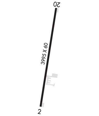
| Lat: N 3841.2 Long: W 08039.1 Elev: 1276 Var: +08 Longest Runway: 3995 | ||
| AWOS: 118.22 CTAF: 122.9 | ||
| ||||||
| ||||||
|
| Rwy | Rwy | |||||||
| 3995x60 | 3194' | 3995x60 | 3995' | |||||
| Runway ID | Single Wheel | Double Wheel | Double Tandem Wheel | Dual Double Wheel |
| 02/20 | 12,000 | N/A | N/A | N/A |
| These numbers are Advisory and are not limits. The Airport Manager should have more accurate Weight Limits | ||||
 Airport Diagram might not be current. | |
| Facility Name: | BRAXTON COUNTY |
| City Name: | SUTTON |
| County: | BRAXTON |
| State abbrev: | WV |
| State Name: | WEST VIRGINIA |
| Ownership: | PUBLICLY OWNED |
| Use: | OPEN TO THE PUBLIC |
| Owner's Name: | CO CMSN OF BRAXTON |
| Address: | BOX 486 |
| SUTTON, WV 26601 | |
| Owner's Phone: | 304-765-2835 |
| Manager's Name: | PATRICK O'MALLEY |
| Address: | 106 BIRCH ST |
| GASAWAY, WV 26624-1102 | |
| Phone: | (304) 542-3311 |
| FAA Region: | EASTERN |
| FAA Field Office: | BKW |
| Date | Sunrise | Sunset |
|---|---|---|
| 09/24/21 Friday | 7:12 | 19:17 |
| 09/25/21 Saturday | 7:13 | 19:15 |
| 09/26/21 Sunday | 7:14 | 19:14 |
| 09/27/21 Monday | 7:15 | 19:12 |
| 09/28/21 Tuesday | 7:15 | 19:10 |
| 09/29/21 Wednesday | 7:16 | 19:09 |
| 09/30/21 Thursday | 7:17 | 19:07 |
| 10/01/21 Friday | 7:18 | 19:06 |
| 10/02/21 Saturday | 7:19 | 19:04 |
| 10/03/21 Sunday | 7:20 | 19:03 |
| 10/04/21 Monday | 7:21 | 19:01 |
| 10/05/21 Tuesday | 7:22 | 19:00 |
| 10/06/21 Wednesday | 7:23 | 18:58 |
| 10/07/21 Thursday | 7:24 | 18:56 |
| Airport Attendance Schedule | UNATTENDED |
| Airport Status | OPERATIONAL (This Status can change at any time - please check NOTAMS) |
| Airport Lighting Schedule | DUSK-DAWN. AFT 2300, ACTVT REIL RWYS 02 & 20; PAPI RWY 20; AND MIRL RWY 02/20 - CTAF. |
| Airport Storage Available | Tie Downs |
| Extra Services Available | Flight Instruction |
| Wind Indicator | YES - (lighted) |
| Control Tower | NO |
| CTAF Frequency | 122.900 |
| Unicom Frequency | |
| Rotating Beacon Color | CLEAR-GREEN (Light Land Airport); BEACON LOCATED 1/4 MILE NW OF AIRPORT. |
| Segmented Circle | YES |
| Landing Fee | NO |
| Airport Inspected | STATE - performed by PRIVATE CONTRACT PERSONNEL |
| Inspection Date | 07/13/2021 |
| Type of Fuel Available | Grade 100LL, JET A (freeze point -40C) |
| Airframe Repair Service | NONE |
| Power Plant Repair Service | NONE |
| Latitude | N3841.2 |
| Longitude | W08039.1 (ESTIMATED) |
| Arpt Elevation | 1275ft (ESTIMATED) |
| Magnetic Variation | 08W |
| 3 miles E | of SUTTON |
| Traffic Pattern Altitude | |
| Sectional Chart | CINCINNATI |
| Operations (Reported) | Yearly | Avg. Daily |
|---|---|---|
| General Aviation Transient | 1500 | 4 |
| General Aviation Local | 1500 | 4 |
| Air Taxi | 0 | 0 |
| Commerical | 0 | 0 |
| Commuter | 0 | 0 |
| Military | 100 | 0 |
| Aircraft based on Field | |
|---|---|
| General Aviation Singles | 8 |
| General Aviation Multi | 2 |
| Jet Aircraft | 0 |
| General Aviation Helicopters | 0 |
| Military Aircraft | 0 |
| Gliders | 0 |
| Ultralights | 0 |
| FSS on field | NO |
| FSS tie-in | ELKINS |
| FSS Phone | 1-800-WX-BRIEF |
| Who issues Notams | EKN |
| Notam D service at airport | YES |
| ARTCC Name | INDIANAPOLIS |
| Airport Certification | |
| Aircraft Rescue & Firefighting Index | None |
| Airport of Entry | No |
| Custom Landing Rights | No |
| Joint Civil/Military | No |
| Military Landing rights | YES |
| NATIONAL PLAN OF INTEGRATED AIRPORT SYSTEMS (NPIAS) |
| GRANT AGREEMENTS UNDER FAAP/ADAP/AIP |
| ASSURANCES PURSUANT TO TITLE VI, CIVIL RIGHTS ACT OF 1964 |
| 6' DITCH CROSSES AER 02 0-116' FROM THLD. |
| GATE ACCESS 0700-1900 1-2-3-4. 1900-0700, 0-7-6-5. |
| FOR CD CTC INDIANAPOLIS ARTCC AT 317-247-2411. |
Airport Communications & Frequencies:
| |||||||||||||||
| Runway: 02 | Runway: 20 | ||
| Mag heading: | 16° | Mag heading: | 196° |
| Rwy Slope: | .58% Up | Rwy Slope: | -.58% Down |
| Approach: | Approach: | ||
| Pattern: | Left Traffic | Pattern: | Left Traffic |
| Markings: | BASIC | Markings: | NONPRECISION INSTRUMENT |
| Marking Condition: | POOR; RWY MKGS FADED. | Marking Condition: | POOR; RY MKGS FADED. |
| Arresting Dev: | Arresting Dev: | ||
| Lat & Long: | N3840.9 W08039.2 | Lat. & Long.: | N3841.6 W08039.1 |
| Elev: | 1252.5 ft. MSL | Elev: | 1275.6 ft. MSL |
| TCH: | TCH: | 40 ft. AGL | |
| Visual Glide Path: | Visual Glide Path: | 4.00 degrees | |
| Displaced Threshold: | 801 feet | Displaced Threshold: | No |
| Touchdown Zone: | YES | Touchdown Zone: | YES |
| Touchdown Elev.: | 1268.0 feet | Touchdown Elev.: | 1275.6 feet |
| Visual Glide Slope: | Visual Glide Slope: | 2-Light PAPI on LEFT side of Runway; UNUSBL BYD 6 DEG LEFT AND BYD 6 DEG RIGHT OF CNTRLN. | |
| RVR Equipment: | RVR Equipment: | ||
| RVV Equipment: | NO | RVV Equipment: | NO |
| Approach Lights: | Approach Lights: | ||
| REIL: | YES | REIL: | YES |
| Centerline Lights: | NO | Centerline Lights: | NO |
| Touchdown lights: | NO | Touchdown lights: | NO |
| Runway Category: | Runway with a Non-precision Approach | Runway Category: | Runway with a Non-precision Approach |
| Declared Distances: | Declared Distances: | ||
| Obstructions: | TREES | Obstructions: | TREES |
| Marked: | NOT Marked/Lighted | Marked: | NOT Marked/Lighted |
| Clearance slope: | APCH RATIO 0:1 TO DSPLCD THLD, 80 FT TREES, 0 FT DSTC, 210 FT L. APCH RATIO 25:1 BASED ON STRAIGHT OUT OVR 53 FT TREES, 1340 FT DSTC, 0 FT B. | Clearance slope: | 14:1 |
| Obstruction height: | 85 feet AGL | Obstruction height: | 137 feet AGL |
| Dist. from runway: | 201 feet | Dist. from runway: | 2230 feet |
| Centerline offset: | 220 right of centerline | Centerline offset: | 449 feet right of centerline |
| Comments: | 26 FT TREES, 0-199, 162 FT L. | Comments: |
Thanks for using FltPlan.com
all rights reserved © 1999-2021 by Flight Plan LLC
