| COCHRAN COCHRAN GA |
| |
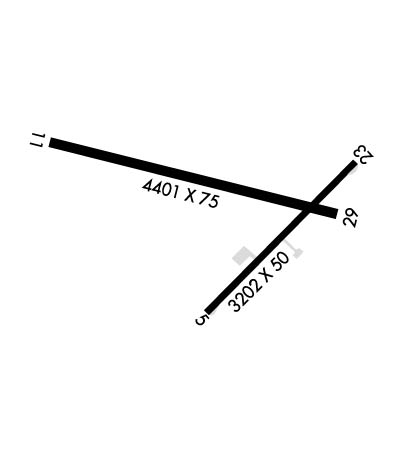
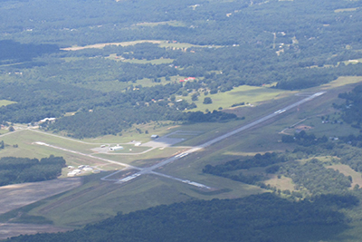
| Lat: N 3224.0 Long: W 08316.7 Elev: 377 Var: +03 Longest Runway: 4400 | ||
| CTAF: 122.8 | ||
| ||||||||||||||||||||||||||||||||||||||||||||||||||||||||||||||||||||
| ||||||||||||||||||||||||||||||||||||||||||||||||||||||||||||||||||||
| Rwy | Rwy | |||||||
| 3202x50 | 3202' | 3202x50 | 3062' | |||||
| 4400x75 | 4400' | 4400x75 | 4400' | |||||
| Runway ID | Single Wheel | Double Wheel | Double Tandem Wheel | Dual Double Wheel |
| 05/23 | 25,000 | N/A | N/A | N/A |
| 11/29 | N/A | N/A | N/A | N/A |
| These numbers are Advisory and are not limits. The Airport Manager should have more accurate Weight Limits | ||||
 Airport Diagram might not be current. | |
| Facility Name: | COCHRAN |
| City Name: | COCHRAN |
| County: | BLECKLEY |
| State abbrev: | GA |
| State Name: | GEORGIA |
| Ownership: | PUBLICLY OWNED |
| Use: | OPEN TO THE PUBLIC |
| Owner's Name: | CITY OF COCHRAN |
| Address: | CITY HALL, PO BOX 8 |
| COCHRAN, GA 31014 | |
| Owner's Phone: | 478-934-6346 |
| Manager's Name: | LISA EISELE |
| Address: | 112 WEST DYKES STREET |
| COCHRAN, GA 31014 | |
| Phone: | 478-934-6346; ALT PHONE 478-230-7843 |
| FAA Region: | SOUTHERN |
| FAA Field Office: | ATL |
| Date | Sunrise | Sunset |
|---|---|---|
| 06/08/26 Monday | 6:26 | 20:39 |
| 06/09/26 Tuesday | 6:26 | 20:39 |
| 06/10/26 Wednesday | 6:25 | 20:40 |
| 06/11/26 Thursday | 6:25 | 20:40 |
| 06/12/26 Friday | 6:25 | 20:41 |
| 06/13/26 Saturday | 6:25 | 20:41 |
| 06/14/26 Sunday | 6:25 | 20:41 |
| 06/15/26 Monday | 6:26 | 20:42 |
| 06/16/26 Tuesday | 6:26 | 20:42 |
| 06/17/26 Wednesday | 6:26 | 20:42 |
| 06/18/26 Thursday | 6:26 | 20:43 |
| 06/19/26 Friday | 6:26 | 20:43 |
| 06/20/26 Saturday | 6:26 | 20:43 |
| 06/21/26 Sunday | 6:26 | 20:43 |
| Airport Attendance Schedule | MON-SAT 0800-1200 |
| Airport Status | OPERATIONAL (This Status can change at any time - please check NOTAMS) |
| Airport Lighting Schedule | MIRL RWY 11/29 PRESET LOW DAWN-0800, DUSK-2100; TO ACTVT OR INCRS INTST - CTAF. |
| Airport Storage Available | Tie Downs |
| Extra Services Available | Crop Dusting |
| Wind Indicator | YES - (lighted) |
| Control Tower | NO |
| CTAF Frequency | 122.800 |
| Unicom Frequency | 122.800 |
| Rotating Beacon Color | WG |
| Segmented Circle | YES |
| Landing Fee | NO |
| Airport Inspected | STATE - performed by STATE AERONAUTICAL PERSONNEL |
| Inspection Date | 03/13/2025 |
| Type of Fuel Available | Grade 100LL; -1024HR FUEL SELF SERV W/MAJOR CREDIT CARD. |
| Airframe Repair Service | MINOR |
| Power Plant Repair Service | MINOR |
| Latitude | N3224.0 |
| Longitude | W08316.7 (ESTIMATED) |
| Arpt Elevation | 377ft (SURVEYED) |
| Magnetic Variation | 03W |
| 4 miles E | of COCHRAN |
| Traffic Pattern Altitude | |
| Sectional Chart | ATLANTA |
| Operations (Reported) | Yearly | Avg. Daily |
|---|---|---|
| General Aviation Transient | 0 | 0 |
| General Aviation Local | 0 | 0 |
| Air Taxi | 0 | 0 |
| Commerical | 0 | 0 |
| Commuter | 0 | 0 |
| Military | 0 | 0 |
| Aircraft based on Field | |
|---|---|
| General Aviation Singles | 0 |
| General Aviation Multi | 0 |
| Jet Aircraft | 0 |
| General Aviation Helicopters | 0 |
| Military Aircraft | 0 |
| Gliders | 0 |
| Ultralights | 0 |
| FSS on field | NO |
| FSS tie-in | MACON |
| FSS Phone | 1-800-WX-BRIEF |
| Who issues Notams | MCN |
| Notam D service at airport | YES |
| ARTCC Name | ATLANTA |
| Airport Certification | |
| Aircraft Rescue & Firefighting Index | None |
| Airport of Entry | No |
| Custom Landing Rights | No |
| Joint Civil/Military | No |
| Military Landing rights | YES |
| NATIONAL PLAN OF INTEGRATED AIRPORT SYSTEMS (NPIAS) |
| ASSURANCES PURSUANT TO TITLE VI, CIVIL RIGHTS ACT OF 1964 |
| GRANT AGREEMENT HAS EXPIRED; HOWEVER, AGREEMENT REMAINS IN EFFECT FOR THIS FACILITY AS LONG AS IT IS PUBLIC USE. |
| NON STD TURNAROUNDS, INADEQUATE SEPARATION RUNWAY 05/23. |
| FOR CD CTC ATLANTA APCH AT 678-364-6132, WHEN APCH CLSD CTC ATLANTA ARTCC AT 770-210-7692. |
| RWY 05/2 3 RWY 5/23 IS DAYLIGHT USE ONLY. |
| RWY 05/2 3 RWY 05/23 PAVEMENT IN POOR COND. |
Airport Communications & Frequencies:
| |||||||||||||||||||||
| Runway: 05 | Runway: 23 | ||
| Mag heading: | 49° | Mag heading: | 229° |
| Rwy Slope: | .26% Up | Rwy Slope: | -.26% Down |
| Approach: | Approach: | ||
| Pattern: | Left Traffic | Pattern: | Left Traffic |
| Markings: | NONPRECISION INSTRUMENT | Markings: | NONPRECISION INSTRUMENT |
| Marking Condition: | GOOD | Marking Condition: | GOOD |
| Arresting Dev: | Arresting Dev: | ||
| Lat & Long: | N3223.8 W08316.8 | Lat. & Long.: | N3224.1 W08316.3 |
| Elev: | 324.2 ft. MSL | Elev: | 332.5 ft. MSL |
| TCH: | TCH: | ||
| Visual Glide Path: | Visual Glide Path: | ||
| Displaced Threshold: | No | Displaced Threshold: | 140 feet |
| Touchdown Zone: | YES | Touchdown Zone: | YES |
| Touchdown Elev.: | 336.4 feet | Touchdown Elev.: | 336.4 feet |
| Visual Glide Slope: | Visual Glide Slope: | ||
| RVR Equipment: | RVR Equipment: | ||
| RVV Equipment: | NO | RVV Equipment: | NO |
| Approach Lights: | Approach Lights: | ||
| REIL: | NO | REIL: | NO |
| Centerline Lights: | NO | Centerline Lights: | NO |
| Touchdown lights: | NO | Touchdown lights: | NO |
| Runway Category: | Runway with a Visual Approach | Runway Category: | Runway with a Visual Approach |
| Declared Distances: | Declared Distances: | TORA:3202' TODA:3202' ASDA:3202' LDA:3062' | |
| Obstructions: | TREES | Obstructions: | TREES |
| Marked: | NOT Marked/Lighted | Marked: | NOT Marked/Lighted |
| Clearance slope: | 11:1 | Clearance slope: | 23:1 |
| Obstruction height: | 44 feet AGL | Obstruction height: | 40 feet AGL |
| Dist. from runway: | 720 feet | Dist. from runway: | 1143 feet |
| Centerline offset: | 88 right of centerline | Centerline offset: | 27 feet left of centerline |
| Comments: | Comments: |
| Runway: 11 | Runway: 29 | ||
| Mag heading: | 107° | Mag heading: | 287° |
| Rwy Slope: | -1.00% Down | Rwy Slope: | 1.00% Up |
| Approach: | Approach: | ||
| Pattern: | Left Traffic | Pattern: | Left Traffic |
| Markings: | NONPRECISION INSTRUMENT | Markings: | NONPRECISION INSTRUMENT |
| Marking Condition: | GOOD | Marking Condition: | GOOD |
| Arresting Dev: | Arresting Dev: | ||
| Lat & Long: | N3224.2 W08317.2 | Lat. & Long.: | N3224.0 W08316.4 |
| Elev: | 377.4 ft. MSL | Elev: | 333.6 ft. MSL |
| TCH: | 45 ft. AGL | TCH: | 40 ft. AGL |
| Visual Glide Path: | 3.25 degrees | Visual Glide Path: | 3.00 degrees |
| Displaced Threshold: | No | Displaced Threshold: | No |
| Touchdown Zone: | YES | Touchdown Zone: | YES |
| Touchdown Elev.: | 377.4 feet | Touchdown Elev.: | 357.7 feet |
| Visual Glide Slope: | 2-Light PAPI on LEFT side of Runway | Visual Glide Slope: | 2-Light PAPI on LEFT side of Runway |
| RVR Equipment: | RVR Equipment: | ||
| RVV Equipment: | NO | RVV Equipment: | NO |
| Approach Lights: | Approach Lights: | ||
| REIL: | NO | REIL: | NO |
| Centerline Lights: | NO | Centerline Lights: | NO |
| Touchdown lights: | NO | Touchdown lights: | NO |
| Runway Category: | Runway with a Non-precision Approach having visibility minimums greater than 3/4 mile | Runway Category: | Runway with a Non-precision Approach having visibility minimums greater than 3/4 mile |
| Declared Distances: | Declared Distances: | ||
| Obstructions: | TREES | Obstructions: | TREES |
| Marked: | NOT Marked/Lighted | Marked: | NOT Marked/Lighted |
| Clearance slope: | 21:1 | Clearance slope: | 31:1 |
| Obstruction height: | 65 feet AGL | Obstruction height: | 68 feet AGL |
| Dist. from runway: | 1585 feet | Dist. from runway: | 2363 feet |
| Centerline offset: | 398 left of centerline | Centerline offset: | 415 feet right of centerline |
| Comments: | Comments: |
Thanks for using FltPlan.com
all rights reserved © 1999-2026 by Flight Plan LLC