
| CURTIS MUNI CURTIS NE |
| |
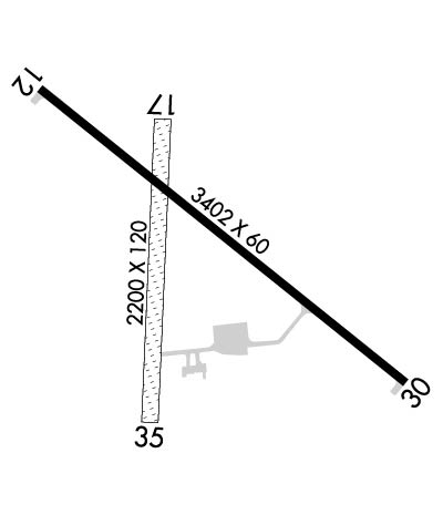
| Lat: N 4038.3 Long: W 10028.4 Elev: 2677 Var: -06 Longest Runway: 3402 | ||
| CTAF: 122.9 | ||
| ||||||
|
| Rwy | Rwy | |||||||
| 3402x60 | 3402' | 3402x60 | 3402' | |||||
| 2200x120 | 2200' | 2200x120 | 2200' | |||||
| Runway ID | Single Wheel | Double Wheel | Double Tandem Wheel | Dual Double Wheel |
| 12/30 | 12,000 | N/A | N/A | N/A |
| 17/35 | N/A | N/A | N/A | N/A |
| These numbers are Advisory and are not limits. The Airport Manager should have more accurate Weight Limits | ||||
 Airport Diagram might not be current. | |
| Facility Name: | CURTIS MUNI |
| City Name: | CURTIS |
| County: | FRONTIER |
| State abbrev: | NE |
| State Name: | NEBRASKA |
| Ownership: | PUBLICLY OWNED |
| Use: | OPEN TO THE PUBLIC |
| Owner's Name: | CURTIS AIRPORT AUTHORITY; RYAN PATE, CHAIRMAN OF AIRPORT AUTHORITY. |
| Address: | PO BOX 11 |
| CURTIS, NE 69025-0011 | |
| Owner's Phone: | (308) 362-7088 |
| Manager's Name: | TOM BROWN |
| Address: | PO BOX 131 |
| CURTIS, NE 69025-0131 | |
| Phone: | (308) 367-7352 |
| FAA Region: | CENTRAL |
| FAA Field Office: | NONE |
| Date | Sunrise | Sunset |
|---|---|---|
| 06/12/26 Friday | 6:10 | 21:13 |
| 06/13/26 Saturday | 6:10 | 21:14 |
| 06/14/26 Sunday | 6:10 | 21:14 |
| 06/15/26 Monday | 6:10 | 21:14 |
| 06/16/26 Tuesday | 6:10 | 21:15 |
| 06/17/26 Wednesday | 6:10 | 21:15 |
| 06/18/26 Thursday | 6:11 | 21:15 |
| 06/19/26 Friday | 6:11 | 21:16 |
| 06/20/26 Saturday | 6:11 | 21:16 |
| 06/21/26 Sunday | 6:11 | 21:16 |
| 06/22/26 Monday | 6:11 | 21:16 |
| 06/23/26 Tuesday | 6:11 | 21:17 |
| 06/24/26 Wednesday | 6:12 | 21:17 |
| 06/25/26 Thursday | 6:12 | 21:17 |
| Airport Attendance Schedule | UNATTENDED |
| Airport Status | OPERATIONAL (This Status can change at any time - please check NOTAMS) |
| Airport Lighting Schedule | ACTVT MIRL RY 12/30 - CTAF. |
| Airport Storage Available | Tie Downs, Hanger |
| Extra Services Available | NONE |
| Wind Indicator | YES - (lighted) |
| Control Tower | NO |
| CTAF Frequency | 122.900 |
| Unicom Frequency | |
| Rotating Beacon Color | WG |
| Segmented Circle | YES |
| Landing Fee | NO |
| Airport Inspected | STATE - performed by STATE AERONAUTICAL PERSONNEL |
| Inspection Date | 07/24/2024 |
| Type of Fuel Available | Grade 100LL; -10FOR FUEL AFT HRS & UNATNDD DAYS CALL AMGR (308) 367-7352. |
| Airframe Repair Service | None |
| Power Plant Repair Service | None |
| Latitude | N4038.3 |
| Longitude | W10028.4 (ESTIMATED) |
| Arpt Elevation | 2677ft (SURVEYED) |
| Magnetic Variation | 06E |
| 2 miles E | of CURTIS |
| Traffic Pattern Altitude | |
| Sectional Chart | OMAHA |
| Operations (Reported) | Yearly | Avg. Daily |
|---|---|---|
| General Aviation Transient | 0 | 0 |
| General Aviation Local | 0 | 0 |
| Air Taxi | 0 | 0 |
| Commerical | 0 | 0 |
| Commuter | 0 | 0 |
| Military | 0 | 0 |
| Aircraft based on Field | |
|---|---|
| General Aviation Singles | 0 |
| General Aviation Multi | 0 |
| Jet Aircraft | 0 |
| General Aviation Helicopters | 0 |
| Military Aircraft | 0 |
| Gliders | 0 |
| Ultralights | 0 |
| FSS on field | NO |
| FSS tie-in | COLUMBUS |
| FSS Phone | 1-800-WX-BRIEF |
| Who issues Notams | OLU |
| Notam D service at airport | YES |
| ARTCC Name | DENVER |
| Airport Certification | |
| Aircraft Rescue & Firefighting Index | None |
| Airport of Entry | No |
| Custom Landing Rights | No |
| Joint Civil/Military | No |
| Military Landing rights | YES |
| NATIONAL PLAN OF INTEGRATED AIRPORT SYSTEMS (NPIAS) |
| GRANT AGREEMENTS UNDER FAAP/ADAP/AIP |
| ASSURANCES PURSUANT TO TITLE VI, CIVIL RIGHTS ACT OF 1964 |
| FOR CD CTC DENVER ARTCC AT 303-651-4257. |
| RWY 17/3 5 RY 17/35 MKD WITH YELLOW CONES. |
Airport Communications & Frequencies:
| |||||||
| Runway: 12 | Runway: 30 | ||
| Mag heading: | 123° | Mag heading: | 303° |
| Rwy Slope: | -.48% Down | Rwy Slope: | .48% Up |
| Approach: | Approach: | ||
| Pattern: | Left Traffic | Pattern: | Left Traffic |
| Markings: | NONPRECISION INSTRUMENT | Markings: | NONPRECISION INSTRUMENT |
| Marking Condition: | GOOD | Marking Condition: | GOOD |
| Arresting Dev: | Arresting Dev: | ||
| Lat & Long: | N4038.5 W10028.7 | Lat. & Long.: | N4038.2 W10028.1 |
| Elev: | 2677.2 ft. MSL | Elev: | 2661.0 ft. MSL |
| TCH: | TCH: | ||
| Visual Glide Path: | Visual Glide Path: | ||
| Displaced Threshold: | No | Displaced Threshold: | No |
| Touchdown Zone: | YES | Touchdown Zone: | YES |
| Touchdown Elev.: | 2677.4 feet | Touchdown Elev.: | 2676.7 feet |
| Visual Glide Slope: | Visual Glide Slope: | ||
| RVR Equipment: | RVR Equipment: | ||
| RVV Equipment: | NO | RVV Equipment: | NO |
| Approach Lights: | Approach Lights: | ||
| REIL: | NO | REIL: | NO |
| Centerline Lights: | NO | Centerline Lights: | NO |
| Touchdown lights: | NO | Touchdown lights: | NO |
| Runway Category: | Runway with a Non-precision Approach | Runway Category: | Runway with a Non-precision Approach |
| Declared Distances: | Declared Distances: | ||
| Comments: | CROPS 5 FT TALL ON BOTH SIDES OF THE RWY, 125 FT L & R AND GOING OUT TO 250 FT L & R FM RWY END. | Comments: | CROPS 5 FT TALL AT THE END OF RWY, 125 FT L AND EXTDG TO 250 FT L. |
| Runway: 17 | Runway: 35 | ||
| Mag heading: | 176° | Mag heading: | 356° |
| Rwy Slope: | -.35% Down | Rwy Slope: | .35% Up |
| Approach: | Approach: | ||
| Pattern: | Left Traffic | Pattern: | Left Traffic |
| Markings: | Markings: | ||
| Marking Condition: | Marking Condition: | ||
| Arresting Dev: | Arresting Dev: | ||
| Lat & Long: | N4038.5 W10028.5 | Lat. & Long.: | N4038.1 W10028.5 |
| Elev: | 2675.6 ft. MSL | Elev: | 2667.9 ft. MSL |
| TCH: | TCH: | ||
| Visual Glide Path: | Visual Glide Path: | ||
| Displaced Threshold: | No | Displaced Threshold: | No |
| Touchdown Zone: | YES | Touchdown Zone: | YES |
| Touchdown Elev.: | 2675.6 feet | Touchdown Elev.: | 2675.6 feet |
| Visual Glide Slope: | Visual Glide Slope: | ||
| RVR Equipment: | RVR Equipment: | ||
| RVV Equipment: | NO | RVV Equipment: | NO |
| Approach Lights: | Approach Lights: | ||
| REIL: | NO | REIL: | NO |
| Centerline Lights: | NO | Centerline Lights: | NO |
| Touchdown lights: | NO | Touchdown lights: | NO |
| Runway Category: | Runway with a Visual Approach | Runway Category: | Runway with a Visual Approach |
| Declared Distances: | Declared Distances: | ||
| Obstructions: | OBSTRUCTION MAY BE CROPS DURING GROWING SEASON. | Obstructions: | |
| Marked: | NOT Marked/Lighted | Marked: | |
| Clearance slope: | 20:1 | Clearance slope: | 20:1 |
| Obstruction height: | Obstruction height: | ||
| Dist. from runway: | Dist. from runway: | ||
| Centerline offset: | Centerline offset: | ||
| Comments: | Comments: |
Thanks for using FltPlan.com
all rights reserved © 1999-2026 by Flight Plan LLC
