
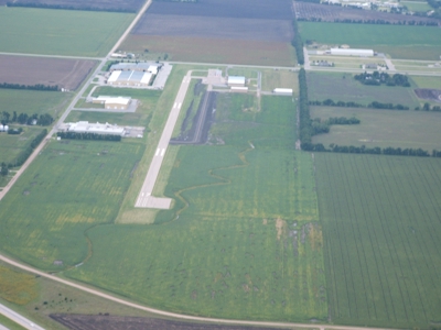
| MOUNDRIDGE MUNI MOUNDRIDGE KS |
| |
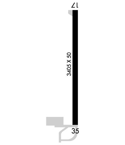
| Lat: N 3812.5 Long: W 09730.2 Elev: 1489 Var: -07 Longest Runway: 3405 | ||
| CTAF: 122.9 | ||
| ||||||||||||||||||||||||||||||||||||||||||||
| ||||||||||||||||||||||||||||||||||||||||||||
| Rwy | Rwy | |||||||
| 3405x50 | 3405' | 3405x50 | 3405' | |||||
| Runway ID | Single Wheel | Double Wheel | Double Tandem Wheel | Dual Double Wheel |
| 17/35 | N/A | N/A | N/A | N/A |
| These numbers are Advisory and are not limits. The Airport Manager should have more accurate Weight Limits | ||||
 Airport Diagram might not be current. | |
| Facility Name: | MOUNDRIDGE MUNI |
| City Name: | MOUNDRIDGE |
| County: | MC PHERSON |
| State abbrev: | KS |
| State Name: | KANSAS |
| Ownership: | PUBLICLY OWNED |
| Use: | OPEN TO THE PUBLIC |
| Owner's Name: | CITY OF MOUNDRIDGE |
| Address: | 225 SOUTH CHRISTIAN AVENUE |
| MOUNDRIDGE, KS 67107 | |
| Owner's Phone: | 620-345-2661 |
| Manager's Name: | MIKE STRAUSZ |
| Address: | 225 SOUTH CHRISTIAN AVENUE |
| MOUNDRIDGE, KS 67107 | |
| Phone: | 620-386-4346; RANDY FRAZER 620-747-0525 |
| FAA Region: | CENTRAL |
| FAA Field Office: | NONE |
| Date | Sunrise | Sunset |
|---|---|---|
| 09/24/21 Friday | 7:19 | 19:24 |
| 09/25/21 Saturday | 7:20 | 19:23 |
| 09/26/21 Sunday | 7:21 | 19:21 |
| 09/27/21 Monday | 7:22 | 19:19 |
| 09/28/21 Tuesday | 7:23 | 19:18 |
| 09/29/21 Wednesday | 7:24 | 19:16 |
| 09/30/21 Thursday | 7:25 | 19:15 |
| 10/01/21 Friday | 7:26 | 19:13 |
| 10/02/21 Saturday | 7:26 | 19:12 |
| 10/03/21 Sunday | 7:27 | 19:10 |
| 10/04/21 Monday | 7:28 | 19:09 |
| 10/05/21 Tuesday | 7:29 | 19:07 |
| 10/06/21 Wednesday | 7:30 | 19:06 |
| 10/07/21 Thursday | 7:31 | 19:04 |
| Airport Attendance Schedule | MON - FRI 0800-1700 |
| Airport Status | OPERATIONAL (This Status can change at any time - please check NOTAMS) |
| Airport Lighting Schedule | |
| Airport Storage Available | Tie Downs, Hanger |
| Extra Services Available | Aircraft Sales |
| Wind Indicator | YES - (unlit) |
| Control Tower | NO |
| CTAF Frequency | 122.900 |
| Unicom Frequency | |
| Rotating Beacon Color | CLEAR-GREEN (Light Land Airport) |
| Segmented Circle | NO |
| Landing Fee | NO |
| Airport Inspected | STATE - performed by STATE AERONAUTICAL PERSONNEL |
| Inspection Date | 08/28/2019 |
| Type of Fuel Available | Grade 100LLMOGAS; -10SELF SERVE FUEL AVBL BY CREDIT CARD. |
| Airframe Repair Service | NONE |
| Power Plant Repair Service | NONE |
| Latitude | N3812.5 |
| Longitude | W09730.2 (ESTIMATED) |
| Arpt Elevation | 1489ft (SURVEYED) |
| Magnetic Variation | 07E |
| 1 miles E | of MOUNDRIDGE |
| Traffic Pattern Altitude | |
| Sectional Chart | WICHITA |
| Operations (Reported) | Yearly | Avg. Daily |
|---|---|---|
| General Aviation Transient | 5500 | 15 |
| General Aviation Local | 4000 | 11 |
| Air Taxi | 0 | 0 |
| Commerical | 0 | 0 |
| Commuter | 0 | 0 |
| Military | 100 | 0 |
| Aircraft based on Field | |
|---|---|
| General Aviation Singles | 14 |
| General Aviation Multi | 0 |
| Jet Aircraft | 0 |
| General Aviation Helicopters | 0 |
| Military Aircraft | 0 |
| Gliders | 0 |
| Ultralights | 0 |
| FSS on field | NO |
| FSS tie-in | WICHITA |
| FSS Phone | 1-800-WX-BRIEF |
| Who issues Notams | ICT |
| Notam D service at airport | YES |
| ARTCC Name | KANSAS CITY |
| Airport Certification | |
| Aircraft Rescue & Firefighting Index | None |
| Airport of Entry | No |
| Custom Landing Rights | No |
| Joint Civil/Military | No |
| Military Landing rights | No |
| PHONE AVBL 24 HRS. |
| FOR CD CTC WICHITA APCH AT 316-350-1520. |
Airport Communications & Frequencies:
| ||||||||||||
| Runway: 17 | Runway: 35 | ||
| Mag heading: | 173° | Mag heading: | 353° |
| Rwy Slope: | -.04% Down | Rwy Slope: | .04% Up |
| Approach: | Approach: | ||
| Pattern: | Left Traffic | Pattern: | Left Traffic |
| Markings: | NONPRECISION INSTRUMENT | Markings: | NONPRECISION INSTRUMENT |
| Marking Condition: | FAIR | Marking Condition: | FAIR |
| Arresting Dev: | Arresting Dev: | ||
| Lat & Long: | N3812.8 W09730.2 | Lat. & Long.: | N3812.3 W09730.2 |
| Elev: | 1489.0 ft. MSL | Elev: | 1487.8 ft. MSL |
| TCH: | TCH: | ||
| Visual Glide Path: | Visual Glide Path: | ||
| Displaced Threshold: | No | Displaced Threshold: | No |
| Touchdown Zone: | YES | Touchdown Zone: | YES |
| Touchdown Elev.: | 1489.0 feet | Touchdown Elev.: | 1489.0 feet |
| Visual Glide Slope: | Visual Glide Slope: | ||
| RVR Equipment: | RVR Equipment: | ||
| RVV Equipment: | NO | RVV Equipment: | NO |
| Approach Lights: | Approach Lights: | ||
| REIL: | NO | REIL: | NO |
| Centerline Lights: | NO | Centerline Lights: | NO |
| Touchdown lights: | NO | Touchdown lights: | NO |
| Runway Category: | Runway with a Non-precision Approach | Runway Category: | Runway with a Non-precision Approach |
| Declared Distances: | Declared Distances: | ||
| Obstructions: | ROAD | Obstructions: | ROAD |
| Marked: | NOT Marked/Lighted | Marked: | NOT Marked/Lighted |
| Clearance slope: | 31:1 | Clearance slope: | 20:1 |
| Obstruction height: | 15 feet AGL | Obstruction height: | 16 feet AGL |
| Dist. from runway: | 670 feet | Dist. from runway: | 525 feet |
| Centerline offset: | 290 left of centerline | Centerline offset: | |
| Comments: | Comments: |
Thanks for using FltPlan.com
all rights reserved © 1999-2021 by Flight Plan LLC